Forecasting meteorology and climate
Open Climate4you homepage
Forecasting
or prediction is the process of estimation of future, unknown situations. In
recent years, climatic forecasting has become a very popular phenomenon. As an
example, in 2007, the Intergovernmental Panel on Climate Changes Working Group
One issued its Forth Assessment Report. This report included forecasts or
predictions of high increases in average global temperatures, and serious harm
resulting from this, during the 21st century.
Early
October 1812 Napoleon in
During the
Crimean War, in November 1854, a major part of the French-English fleet was
destroyed in the
However, up to about the 2nd World War weather forecasting was more or less limited to meteorologists plotting the travel and development of individual weather systems on the weather map day by day, steered by winds at higher altitudes, until their ultimate decay or absorption in another weather system. Only when a anticyclone (high pressure area) decided to settle over a certain geographical position, outlooks or forecasts for two or three days ahead could be made. This has all changed very much after the the arrival of powerful computers.
Click here to jump back to the list of content.
The
rapid development of sophisticated weather forecasts has had other consequences
than just improved weather forecasts. One important effect of this and other
scientific developments has been that since around 1935 there has been systematic research done on the issue of forecasting or
making predictions. This rapidly evolving research branch has, among other
things, summarized all useful knowledge about forecasting in what is called the Principles
of Forecasting. These 140 principles are based on empirical studies that compare
methods to determine which ones provide the most accurate forecast in specified
situations, so the resulting principles are in essence what might be designated
as evidence-based principles. A recent review of new evidence on some of the key
principles of forecasting was published by Armstrong
(2006).
Green
and Armstrong (2007) recently attempted an evaluation of the forecasting
processes described in Chapter 8 of the IPCC's WG1 Report (2007). They were able
to find enough information to make judgement on 89 out of the 140 forecasting
principles. Of these 89 principles 72 were violated by the forecasting
procedures described in the report. The authors concluded that the scientific
values of the forecast made thereby were reduced to essentially just the
personal opinion of the scientist involved.
Click here to read a statisticians evaluation of the recent global temperature changes (since 1998) compared to the IPCC-temperature forecasts (located on the Public Policy Forecasting website).
Click here to jump back to the list of content.
Public
policy decisions related to climate change are now usually based on forecast by
climate experts, especially if the experts tend to agree. It is, however,
slightly disturbing to find that many previous examples of expert climate
forecasts have turned out to be completely wrong. A classic example is the
widespread anxiety in the 1970'es of the prospect of a coming ice age.
During
the past decades the methodology for climate forecasting has shifted from
surveys of experts opinions to the use of numerical
climate models. Climate
models are, however, only a mathematical way for experts to express their
opinions about how the real world operates, so nothing has really changed. Pilkey
and Pilkey-Jarvis (2007) examined long-term climate forecasts and concluded
that they were based only on the opinion of the scientist, expressed in complex
mathematical terms without evidence on the validity on the chosen approach.
What
remains is simply to compare published forecasts with the real world and, based
on this, evaluate their degree of success. This empirical approach is also the
foundation for the Principles
of Forecasting. An example of this is
presented at the bottom of this page.
The
reason for this boils down to the
initial value problem.
Knowing the present weather conditions is paramount for forecasting the weather
tomorrow. Numerical computer models integrating many physical laws attempt to
overcome the problem of forecasting the future many days (or years) ahead by
their sheer number crunching power.
Modern
weather forecast is usually reliable within 2 or 3 days. Beyond 4 or 5 days the
quality declines rapidly, partly because it still has not been possible to
forecast the development of jet streams. So,
It is not possible to
predict details of weather further ahead, than a few days, a consequence of “chaos” in the
atmosphere. On the other hand, the present conditions in the oceans will affect the average weather over a
period of weeks, months or even years to come. So given knowledge of the present
ocean state
(e.g., sea
surface temperature and distribution of the sea
ice cover),
it is perhaps possible to predict how the probability of particular future outcomes is enhanced
or diminished.
Click here to jump back to the list of content.
This brings us to seasonal
forecasting. Seasonal forecasting usually have a time horizon of 1-6 months.
They relies primarily on information about the ocean and various other initial
conditions (the current weather) as a constraint on the future climatic
development. As slightly
different initial values may cause very different results, the models are run
several times, using slightly different initial conditions. The spread of
modelling results are then taken as a kind of forecast uncertainty, e.g. that
associated with chaos in the atmosphere. The generation of seasonal
forecasts is now an important
operational activity at various meteorological or climatic centres worldwide.
The work put into the production of seasonal forecasts is impressive.
Current frontiers in
climate forecasting are to improve forecast skill through more observations, to
improve the use of observations, to improve climate models, forecasting regional
details, and the ability of forecasting extreme events like heat waves, droughts,
etc. In addition, an improved quantification of forecast uncertainty is needed.
Click here to jump back to the list of content.
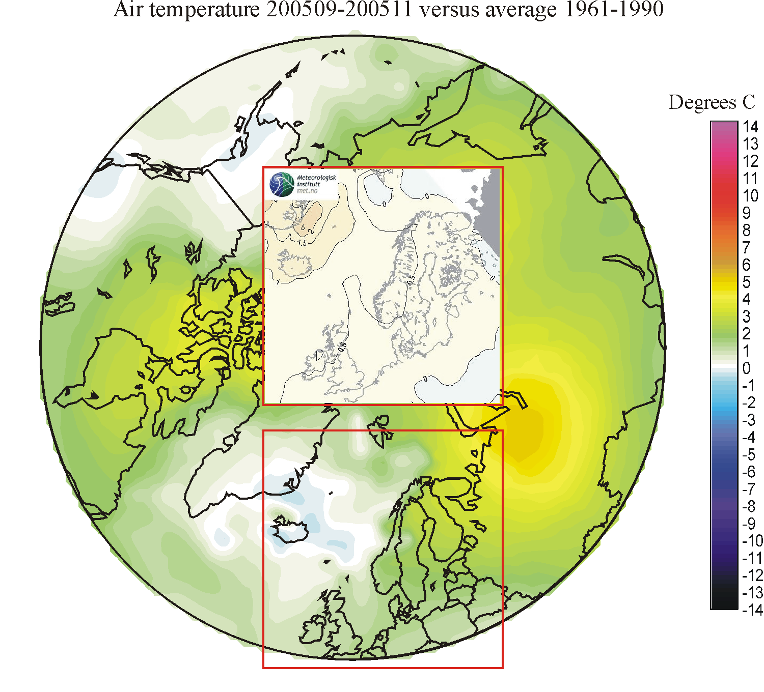
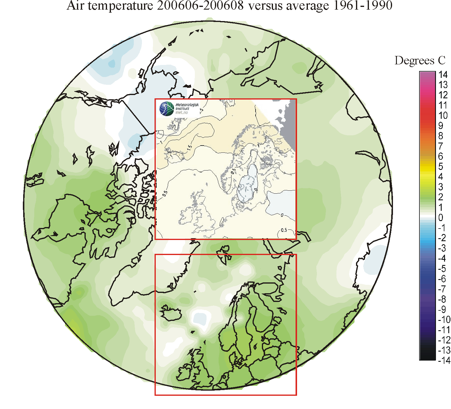
Visual test of
seasonal weather forecasting
Seasonal
or three-monthly forecast for northwest
Below
you will find a suite of three-month temperature forecast for NW Europe,
compared with the real world spatial development. When comparing the different
forecasts, it is useful to remember that summer seasons tend to vary little from
year to year, while winter seasons may show large interannual variations. For
that reason it is of cause easier to forecast a summer season compared to a
winter season. Spring and autumn seasons take an intermediate position in this
respect.
In
the individual diagrams the forecast is shown as an insert on top of the real
world temperature deviation from the 1961-1990 average. Although the colour
scales used are different, a visual comparison is easy to carry out, identifying
both geographical areas where the forecast performs well, and areas where it
performs less well.
Click here to jump back to the list of content.
Spatial comparison of forecasting versus observations
| TIME | 01-03 | 02-04 | 03-05 | 04-06 | 05-07 | 06-08 | 07-09 | 08-10 | 09-11 | 10-12 | 11-01 | 12-02 |
| 2005-06 | 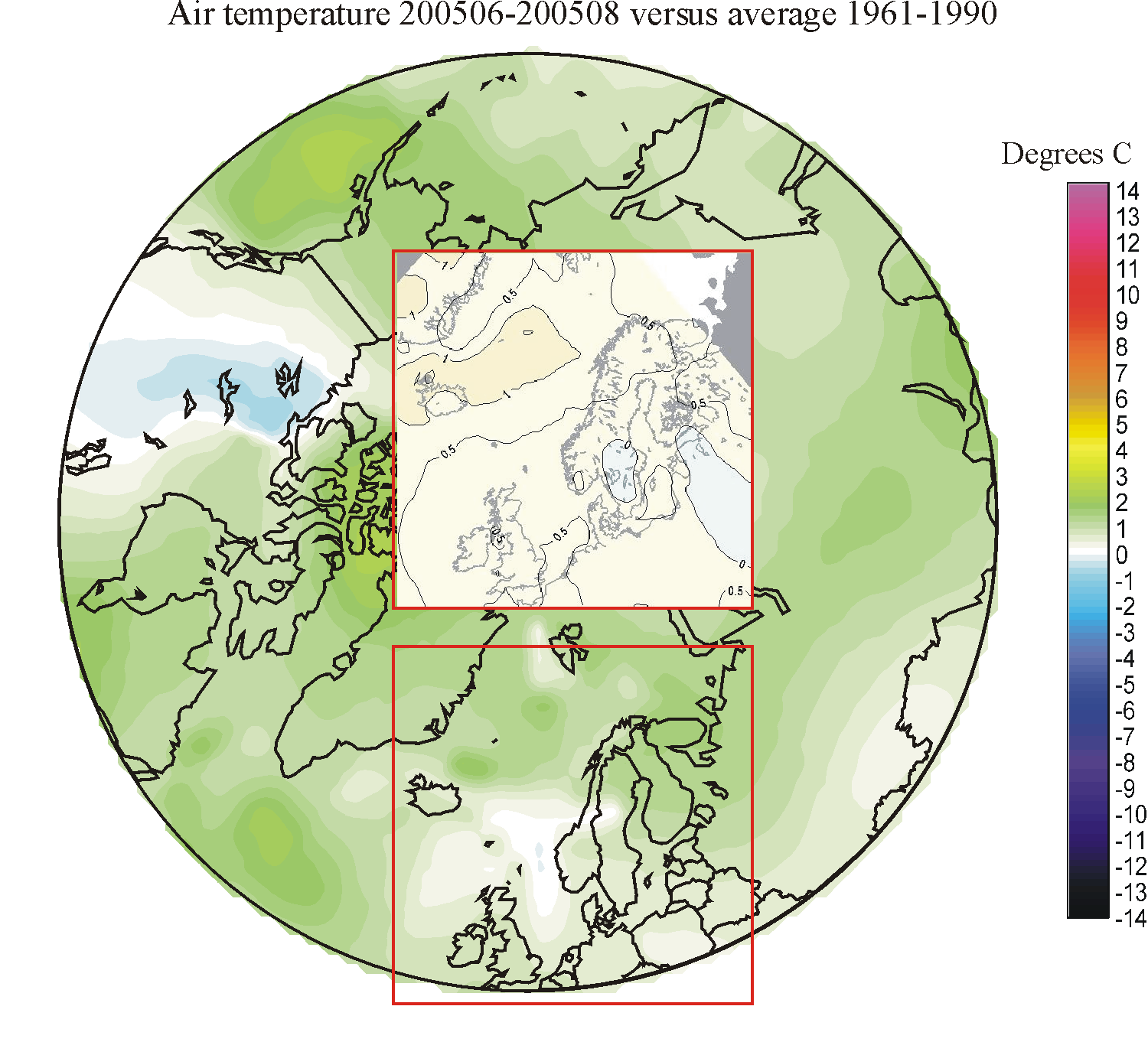 |
 |
||||||||||
| 2006-07 | 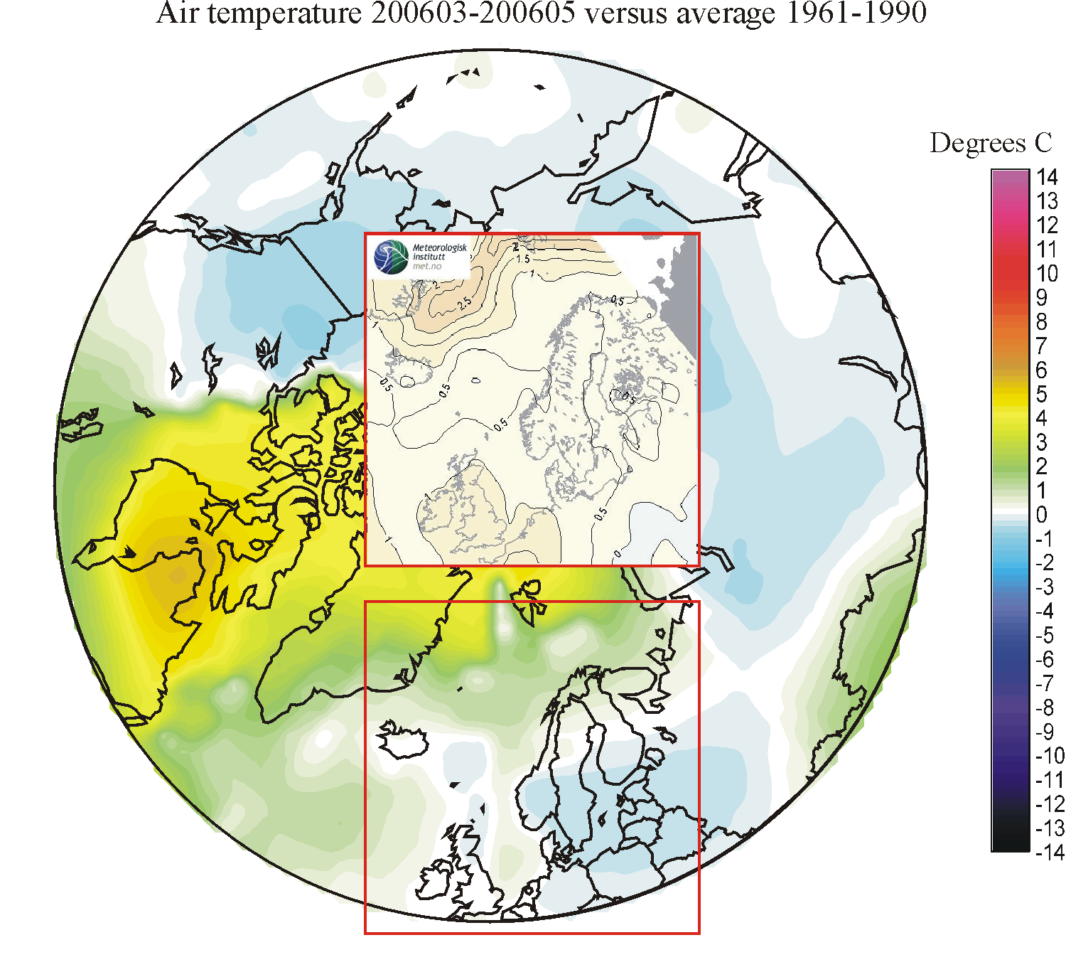 |
 |
 |
 |
||||||||
| 2007-08 |  |
 |
 |
 |
 |
 |
 |
 |
 |
 |
 |
 |
| 2008-09 | 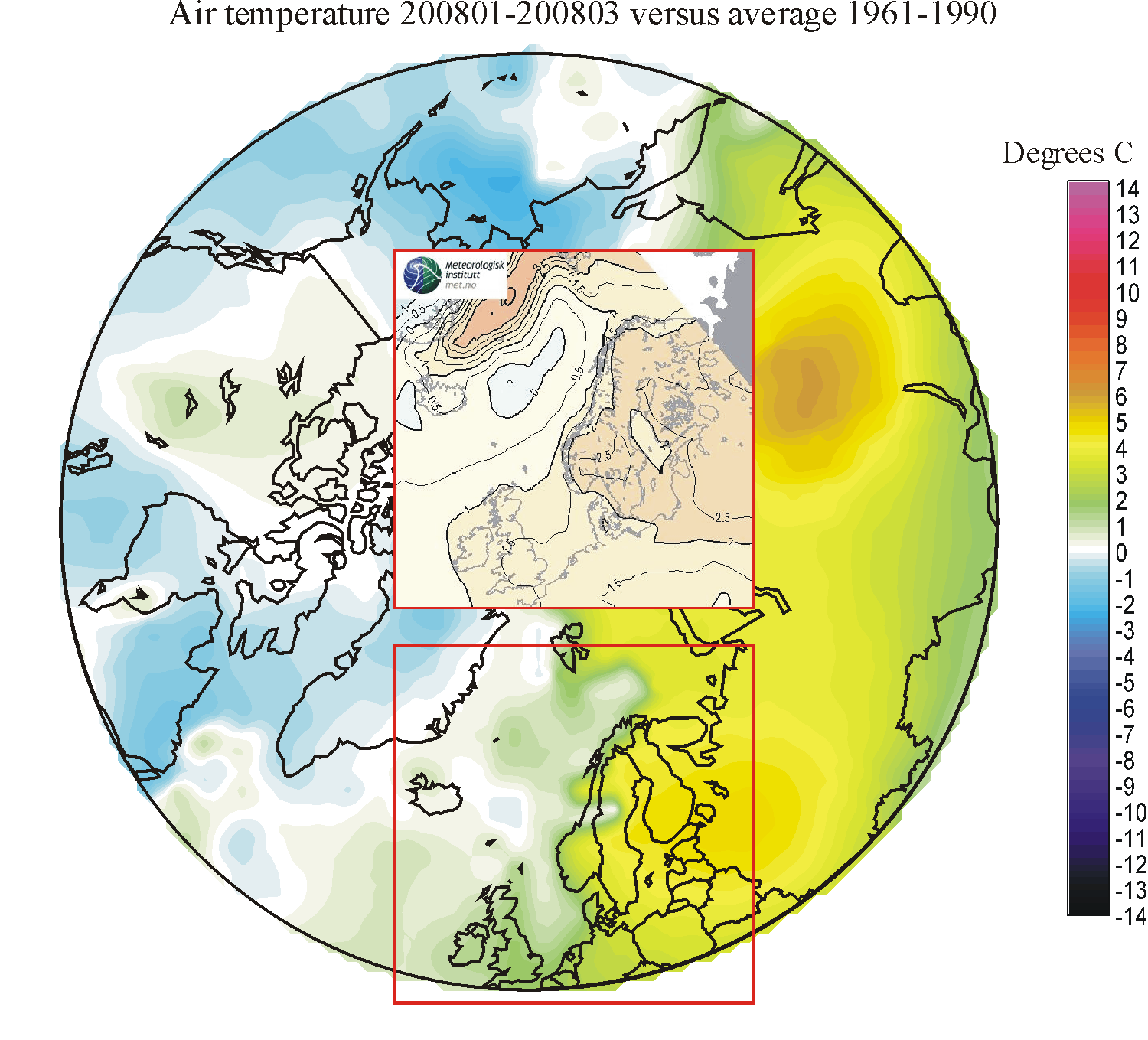 |
 |
 |
 |
 |
 |
 |
 |
 |
 |
 |
 |
| 2009-10 | 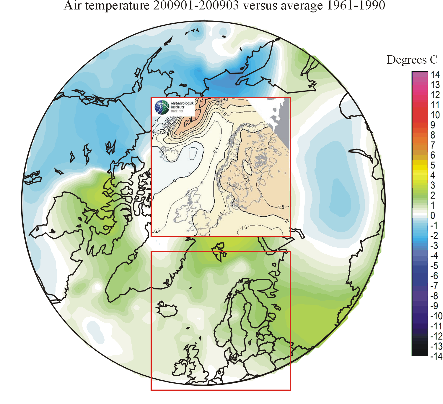 |
 |
 |
 |
 |
 |
 |
 |
 |
 |
 |
 |
| 2010-11 | 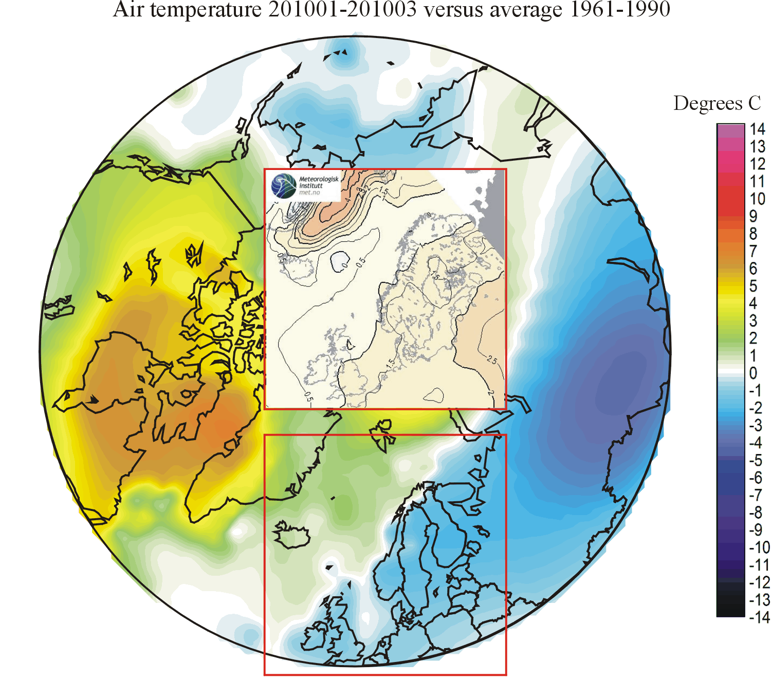 |
 |
 |
 |
 |
 |
 |
 |
 |
 |
 |
 |
| 2011-12 | 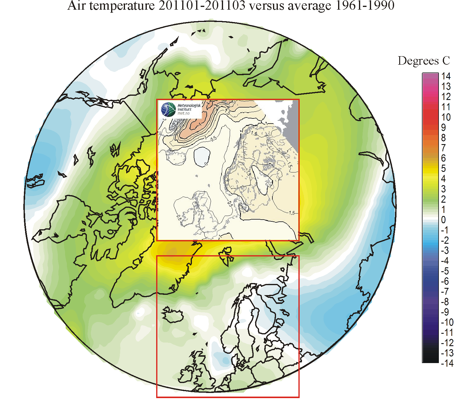 |
 |
 |
 |
 |
 |
 |
 |
 |
 |
 |
 |
| 2012-13 |  |
 |
 |
 |
 |
 |
 |
 |
 |
 |
 |
 |
| 2013-14 | 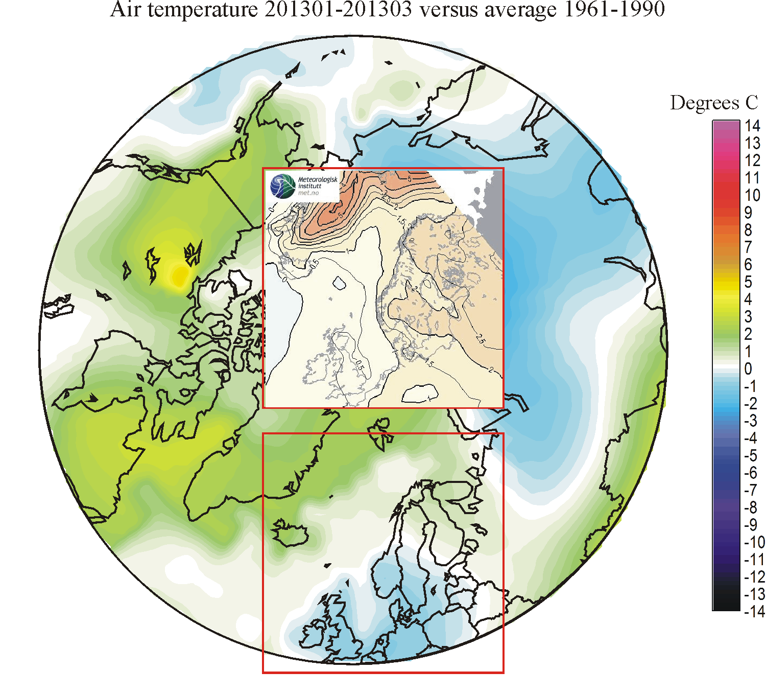 |
 |
 |
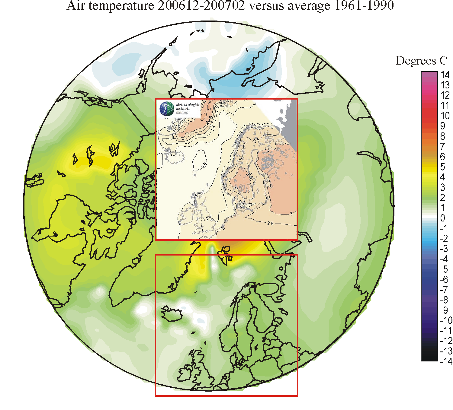
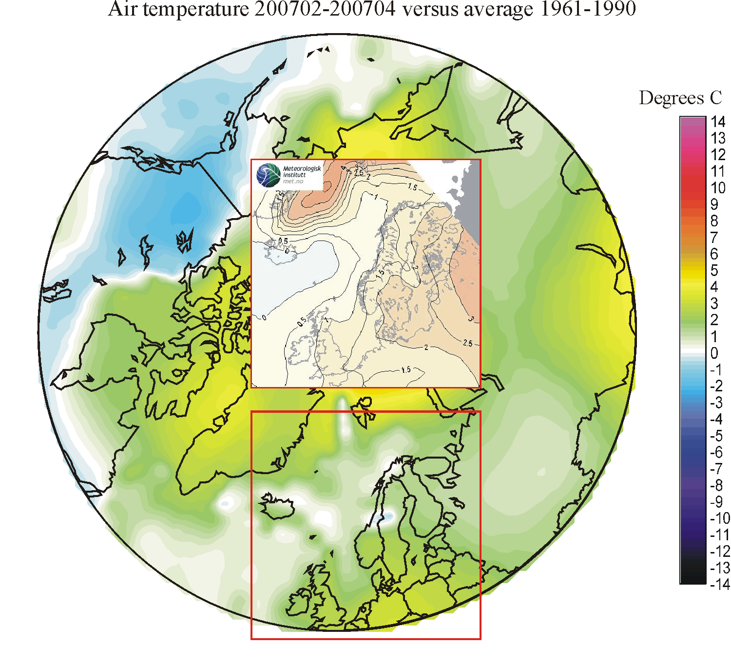
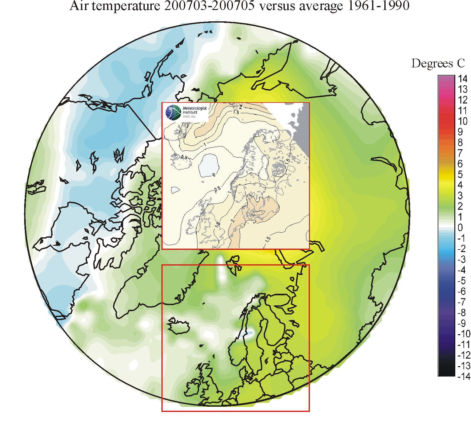
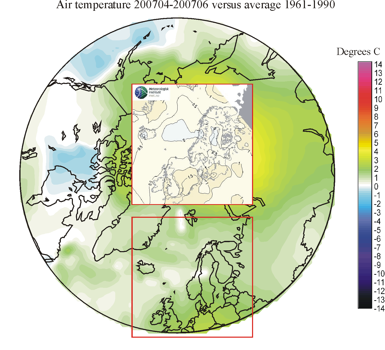
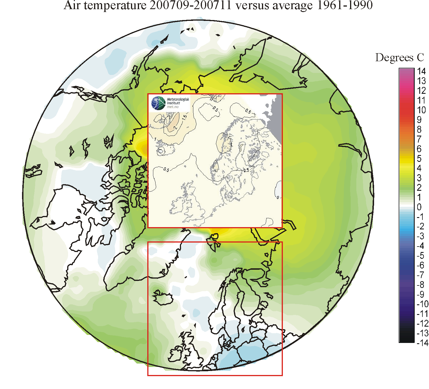
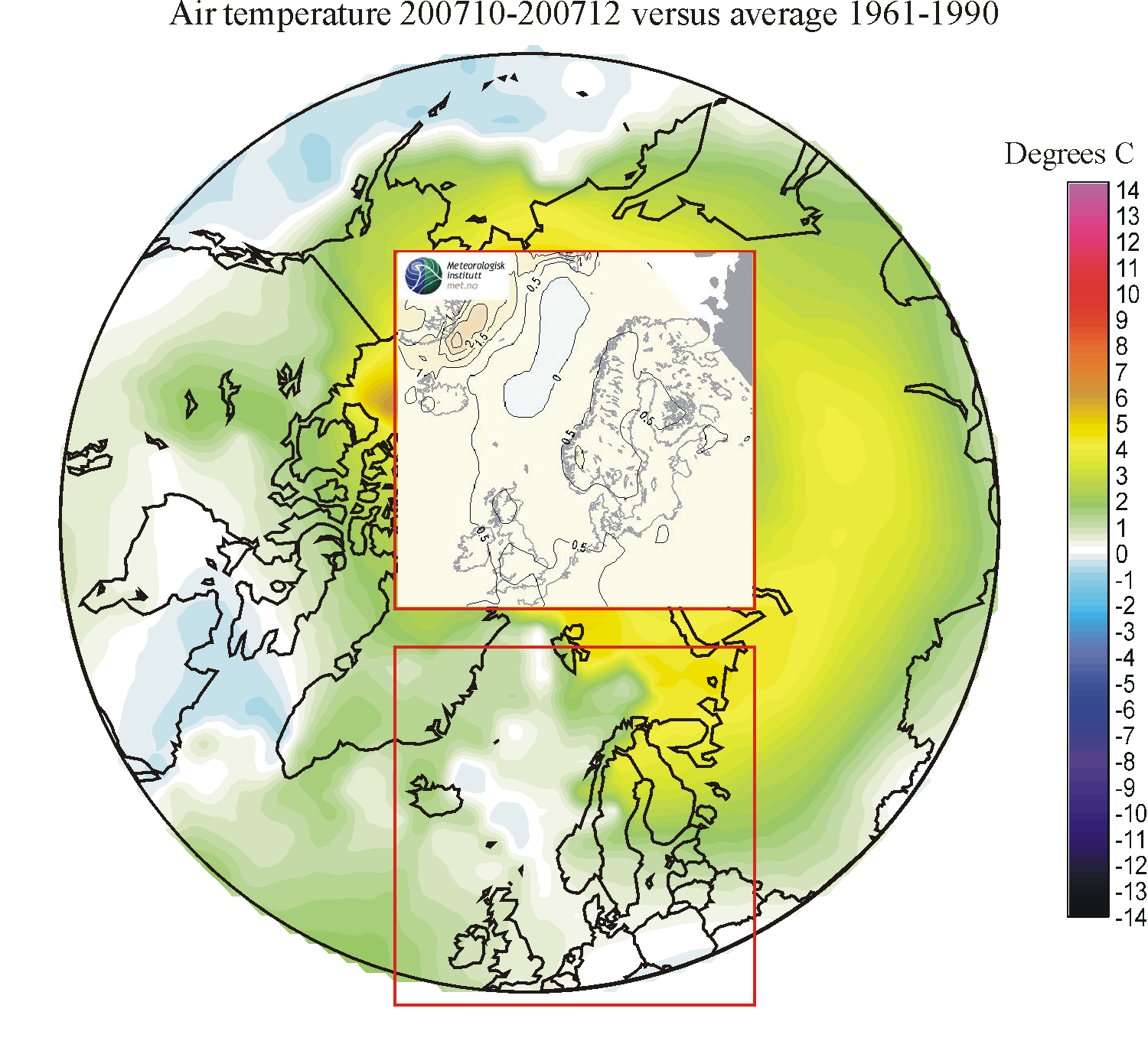
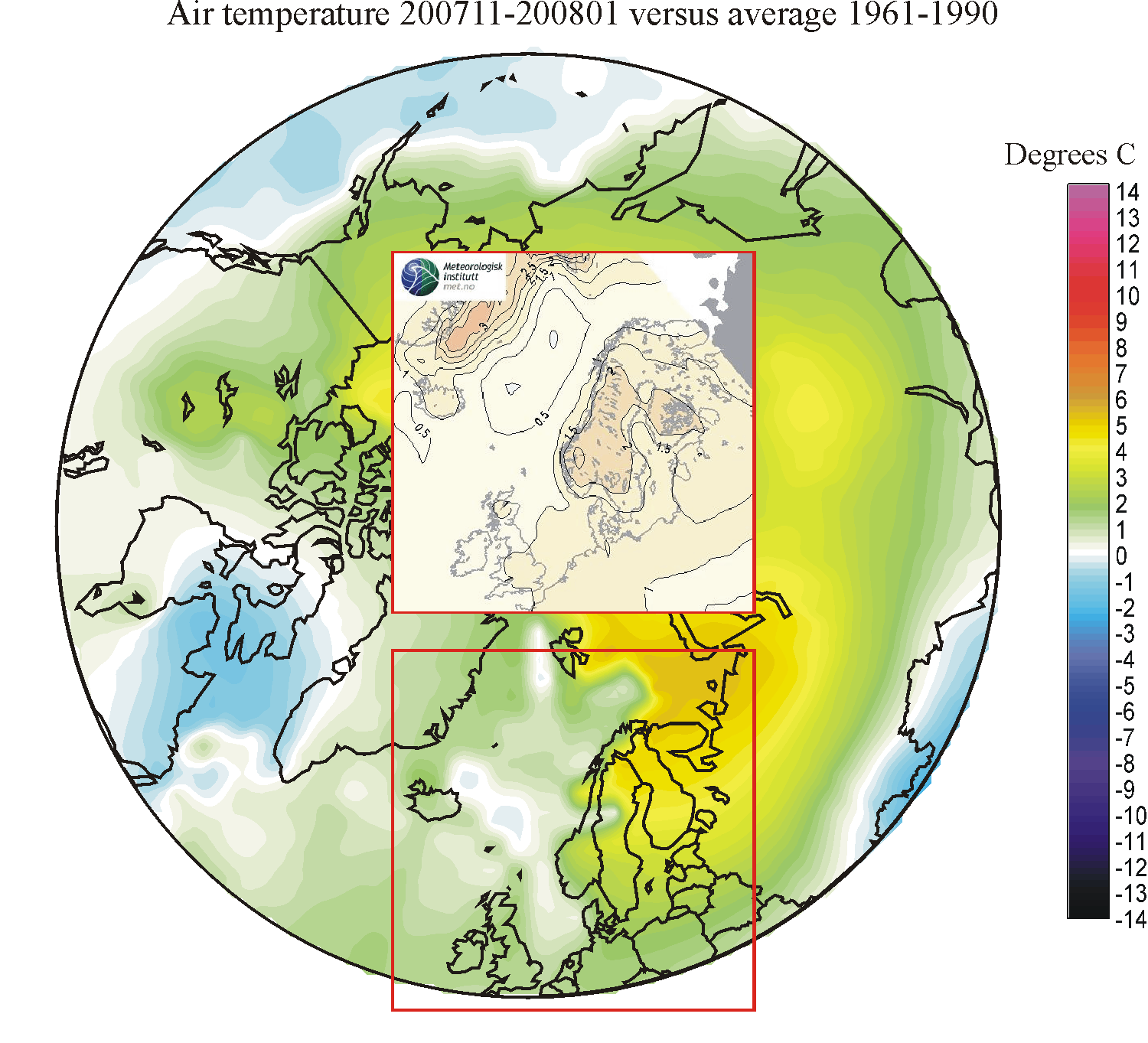
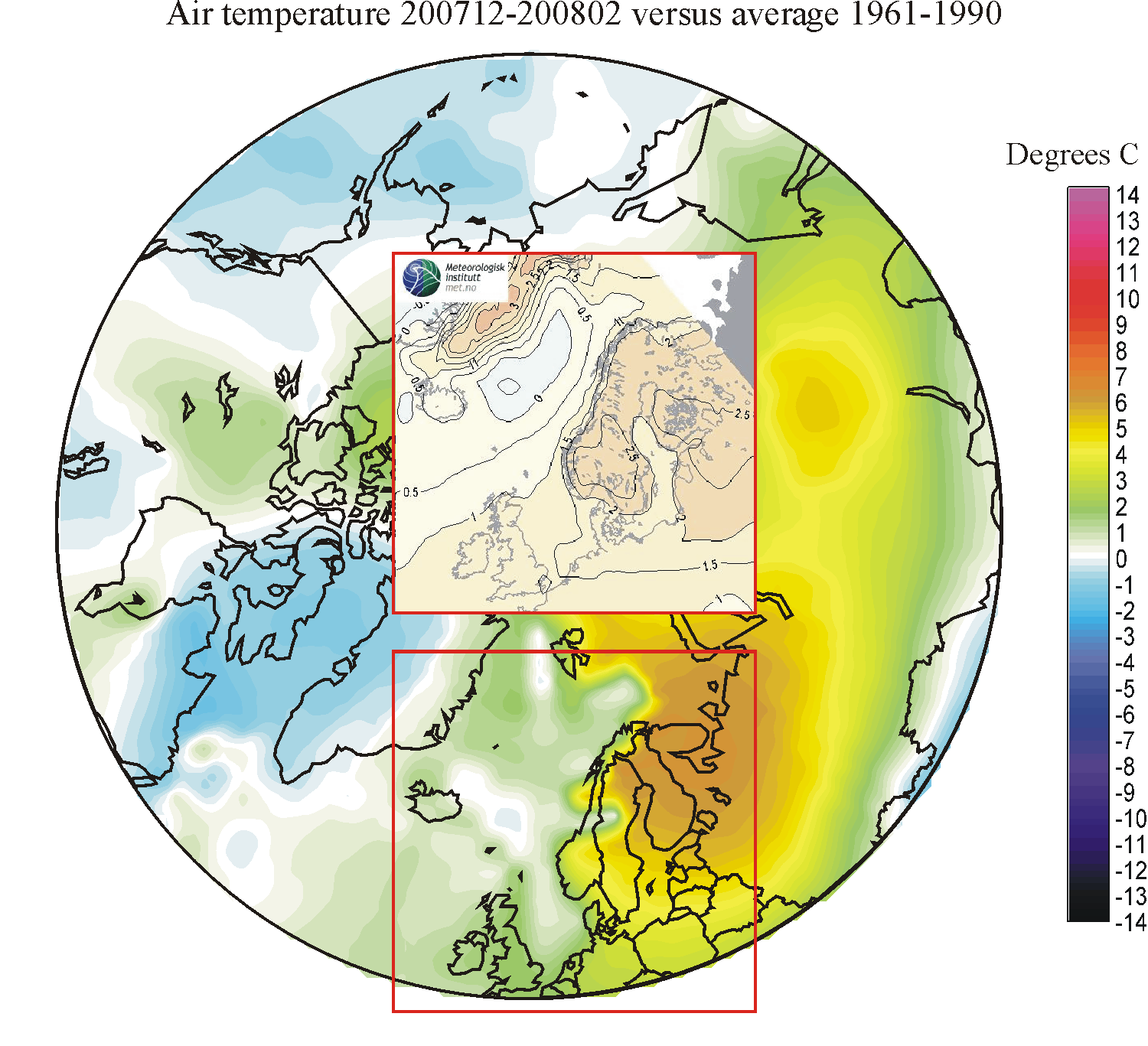
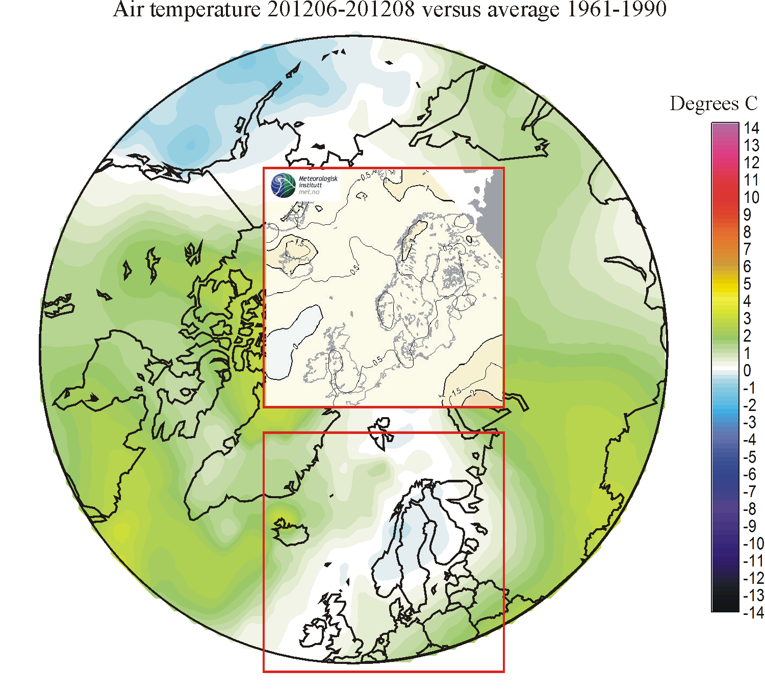
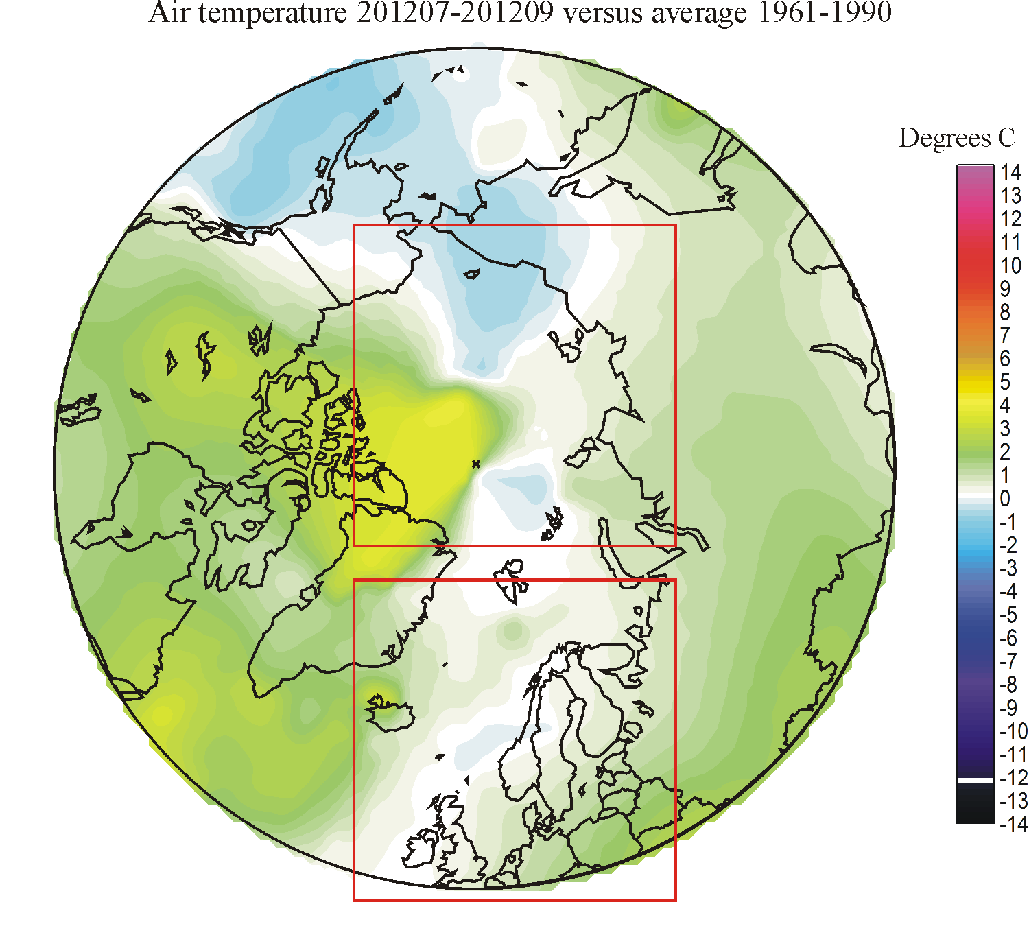
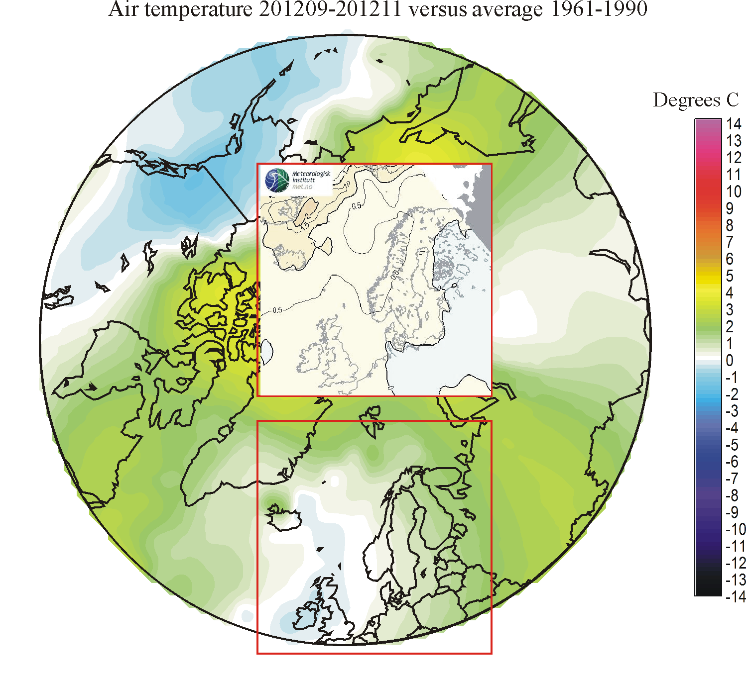
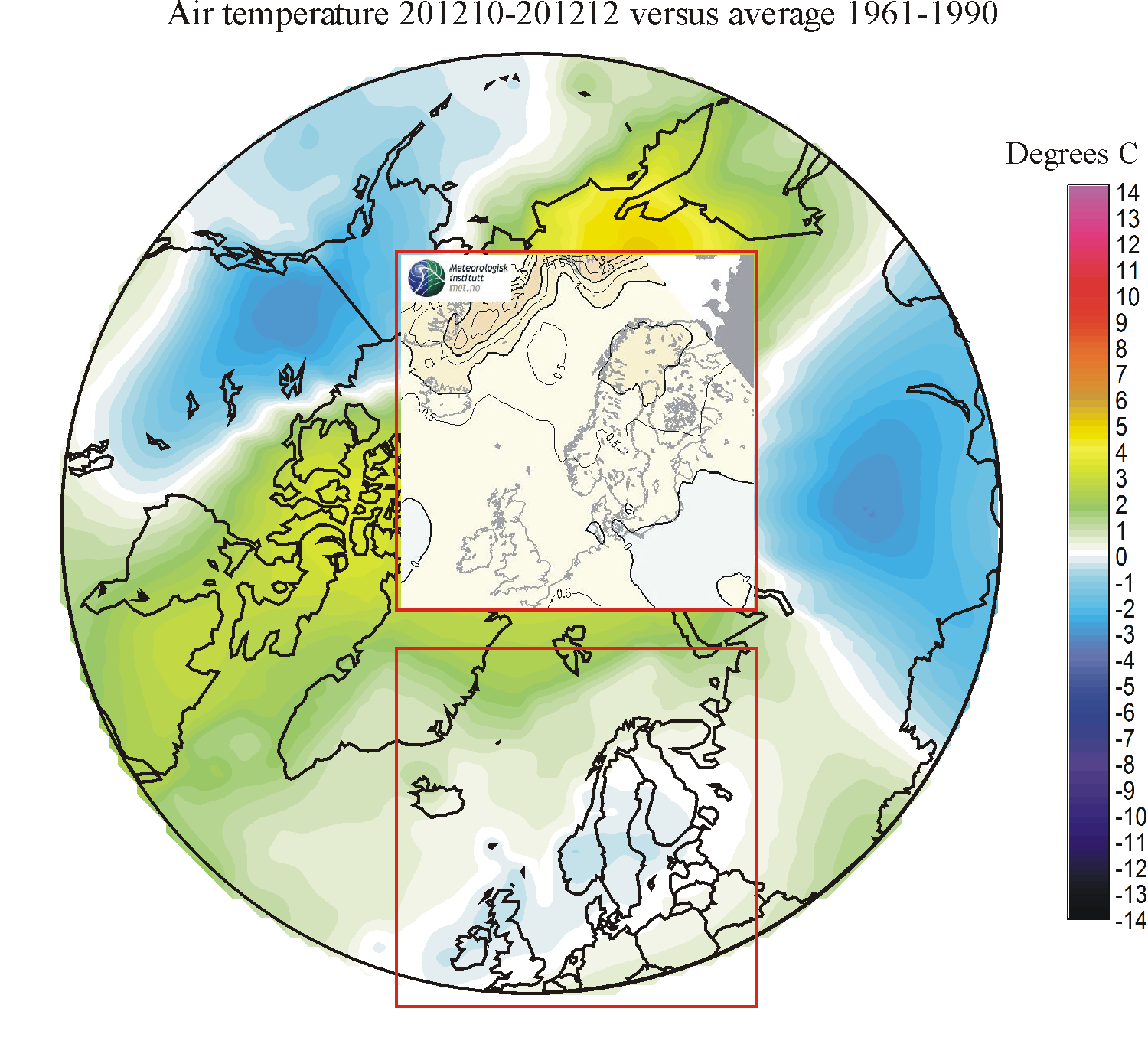
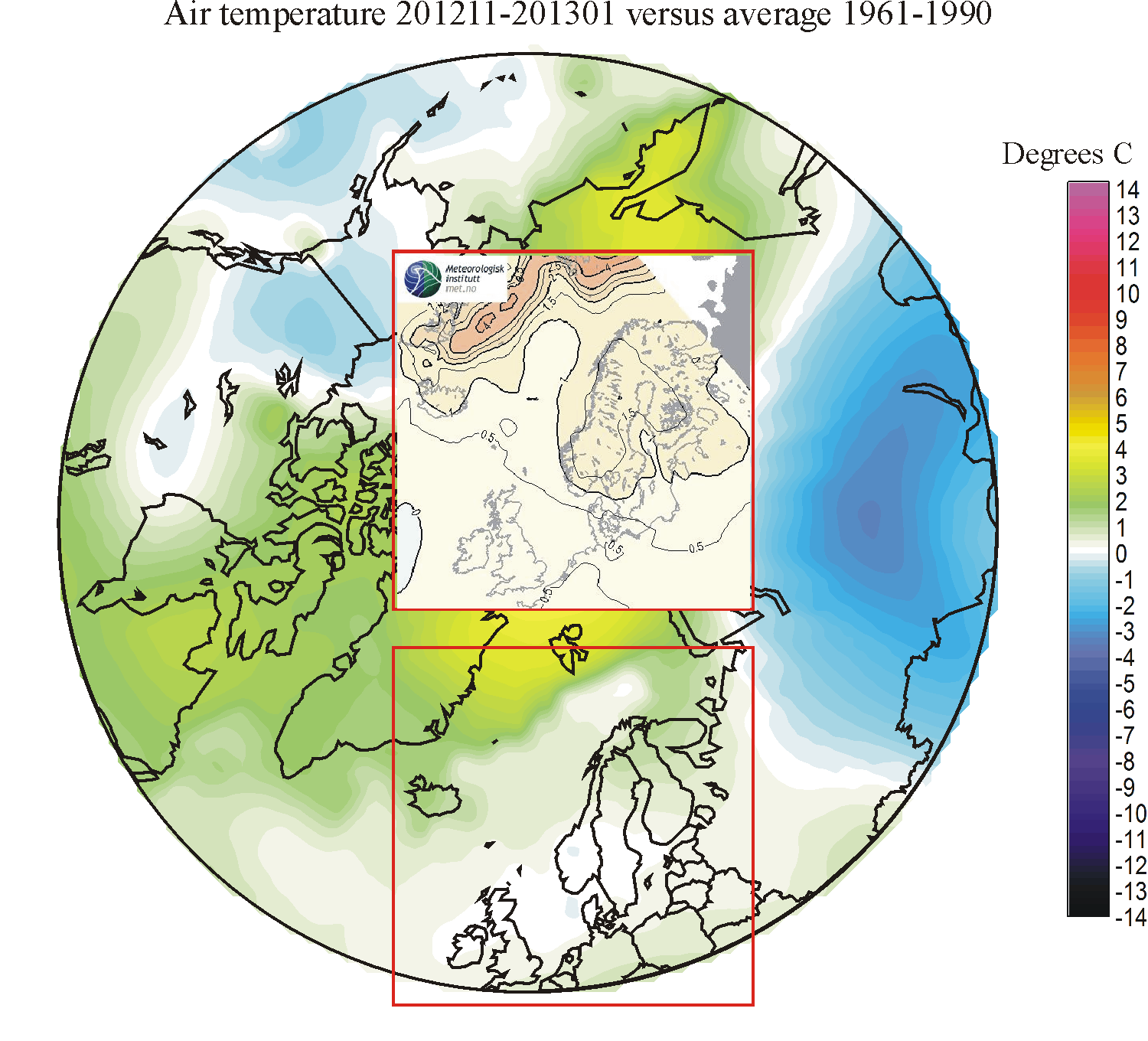
Seasonal forecasts (three-month periods); modelled (insert) versus observations. Click on each of the small diagrams to open a corresponding, but larger diagram. See also comments below on the success of the seasonal forecasts. Reference period: 1961-1990. Latest period updated: January-March 2013. Last diagram update: 17 April 2013.
Comments to the spatial comparison (diagrams above)
201301-201303: The forecast not very successful. Forecasted temperature for NW Europe were low compared to what was forecasted, in certain areas even below the 1961-90 average.
201211-201301: The forecast not very successful. Forecasted temperature for NW Europe were above the 1961-90 average, while in the real world temperatures turned out to be below or near the average.
201210-201212: The forecast not highly successful. The real world had below 1961-90 average temperatures over NW Europe, while the forecast was for above average temperatures.
201209-201211: The forecast not successful. The forecast was for low temperatures in the eastern part of the European forecast region and high temperatures in the western part. The real world turned out to shoe the opposite temperature pattern.
201208-201210: The forecast not entirely successful. Temperatures for most of the the forecasting region turned out to be lower than forecasted.
201206-201208: The forecast not very successful. Temperatures for most of the the forecasting region turned out to be lower than forecasted.
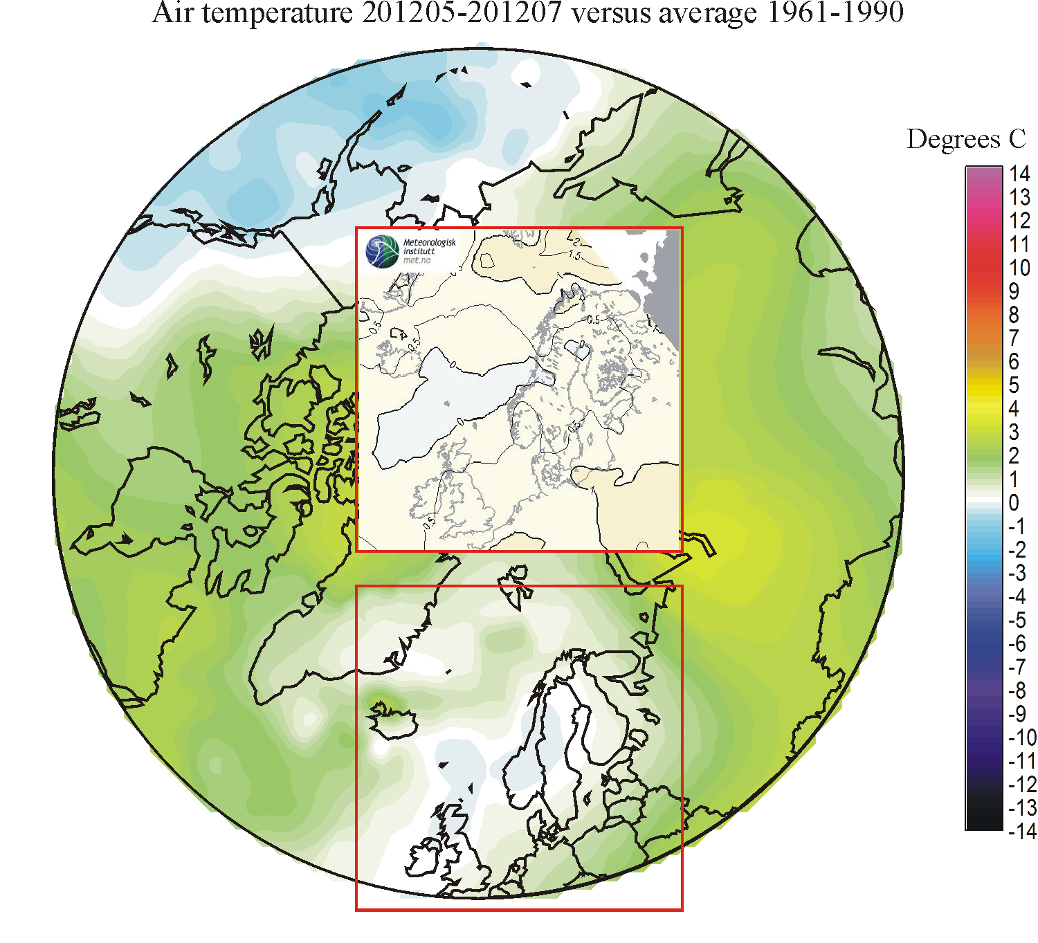
201205-201207: The forecast not successful. Temperatures for most of the the forecasting region turned out to be considerably lower than forecasted.
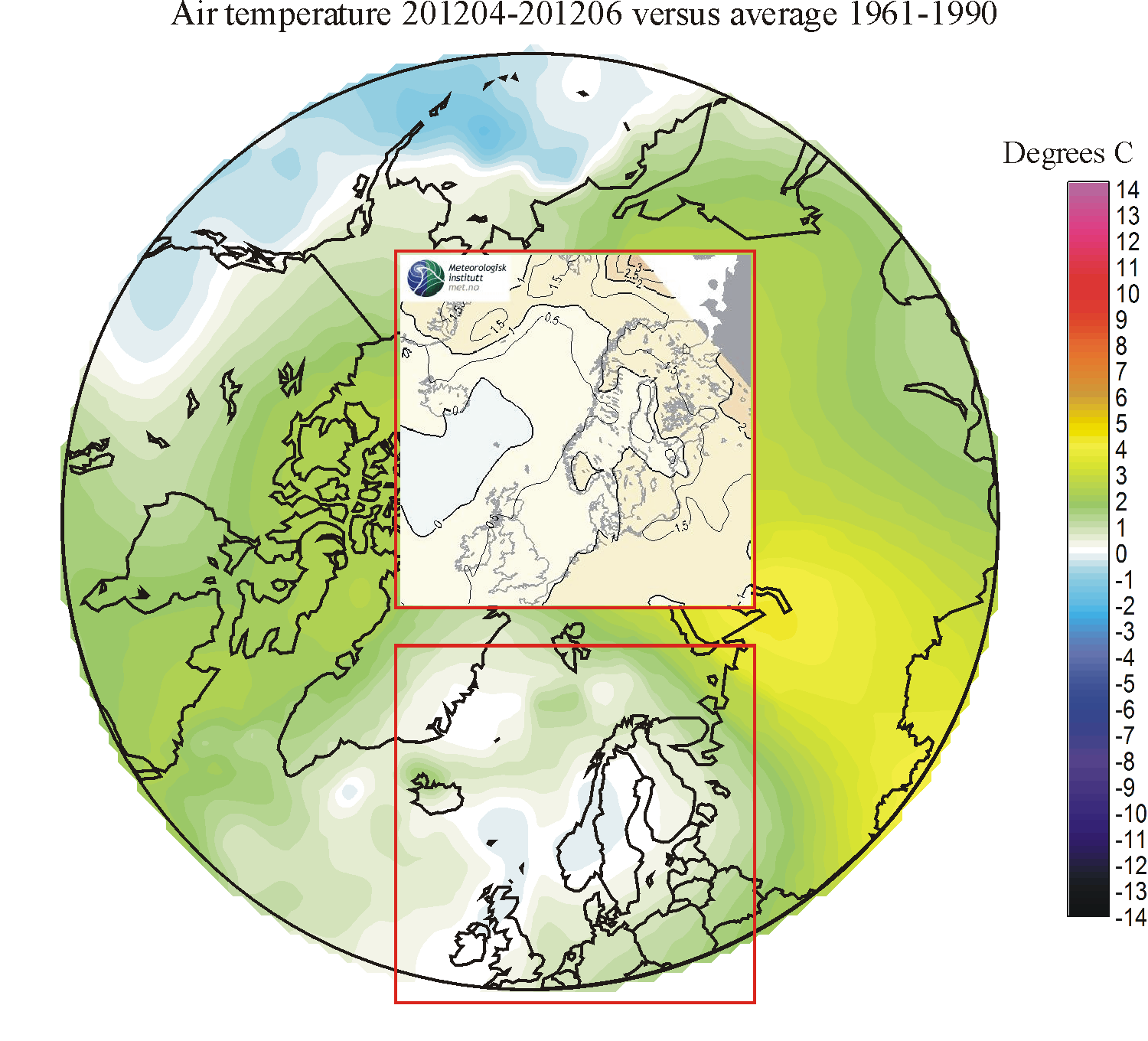
201204-201206: The forecast not very satisfying. Although relative high temperatures correctly were forecasted for northern Russia, temperatures for the remaining part of the forecasting area were below what was forecasted, this error being especially pronounced for NW Europe.
201203-201205: The forecast very good, getting temperature anomalies as well as the overall pattern correct. The only major error was along the east coast of Greenland, where temperatures were lower than forecasted.
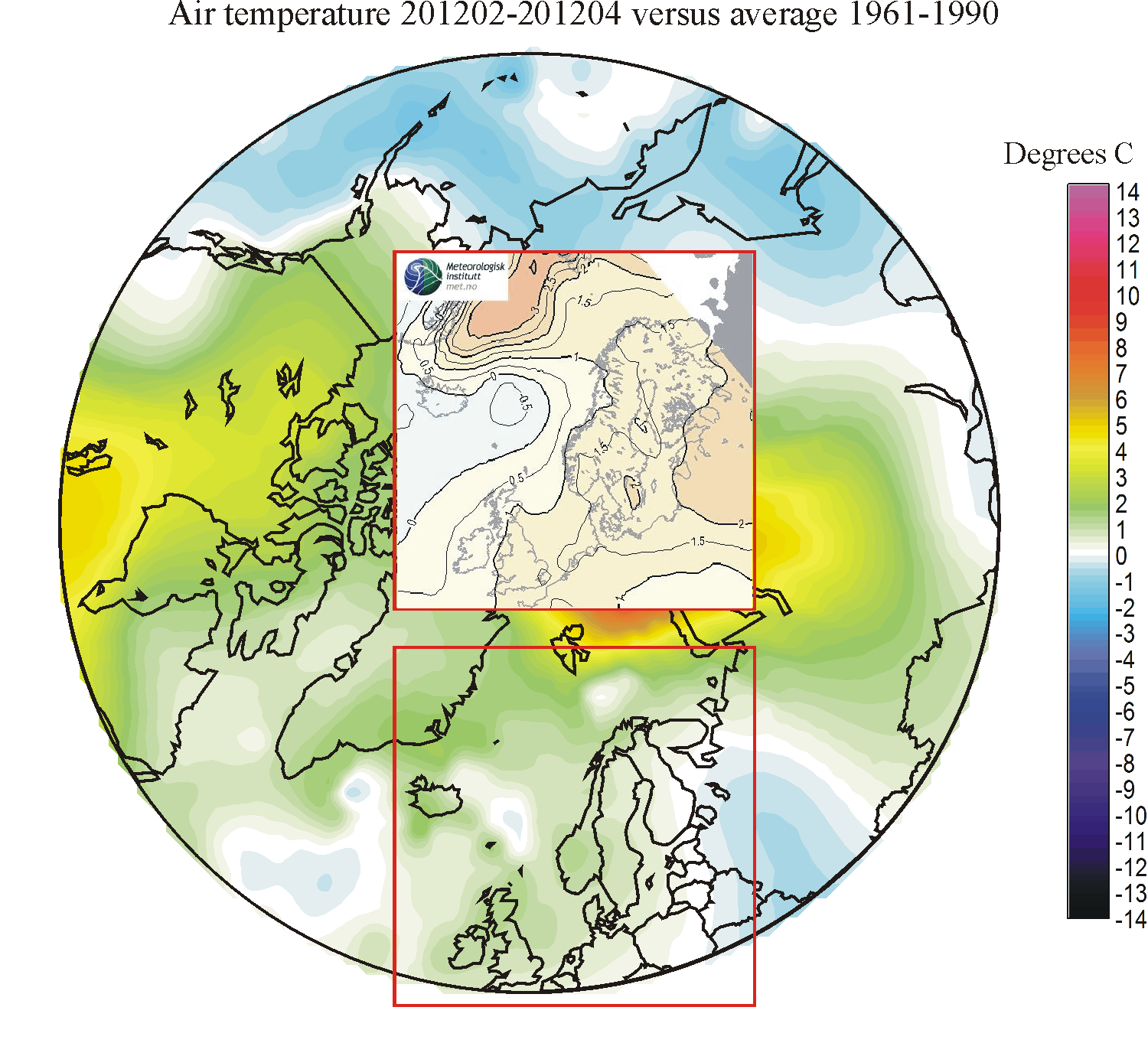
201202-201204: The forecast was not good. The east-west temperature contrast across northern Europe and the Norwegian and Greenland Sea was to some degree opposite to what was forecasted.
201201-201203: The forecast was not entirely satisfactory, and the geographical distribution of temperature anomalies was not forecasted very well.
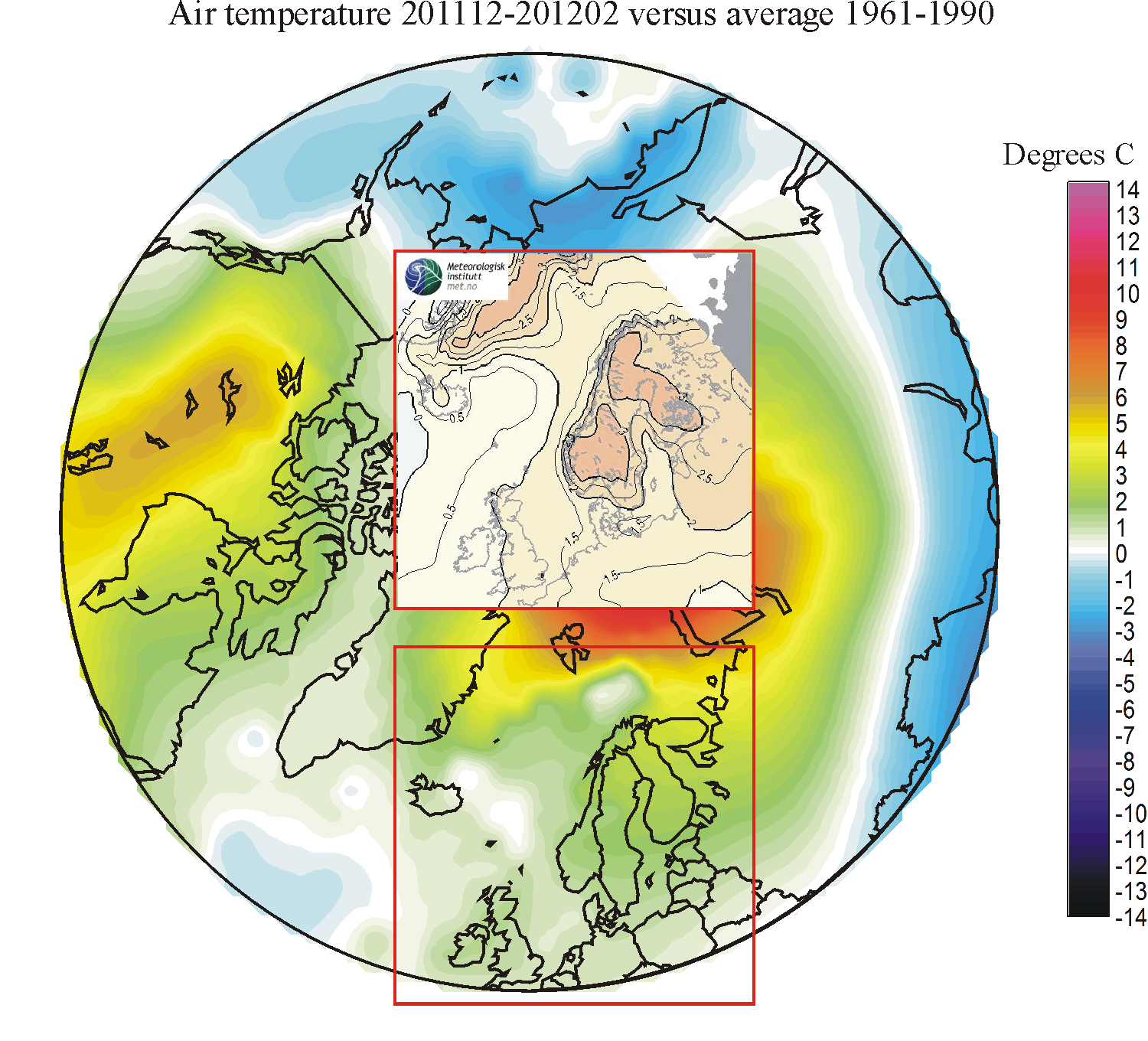
201112-201202: The forecast was satisfactory, although not quite up to the standard of the previous five months. The overall pattern of change was forecasted to some degree, but the warm peaks over Scandinavia did not materialise.
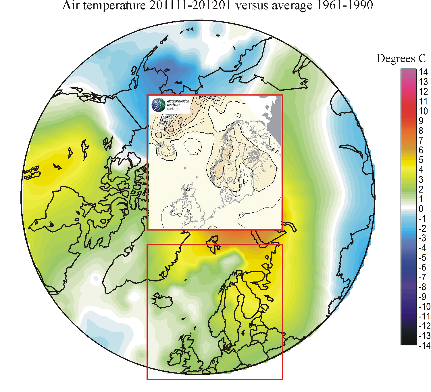
201111-201201: The forecast was satisfactory, with a overall realistic representation of the overall anomaly pattern.
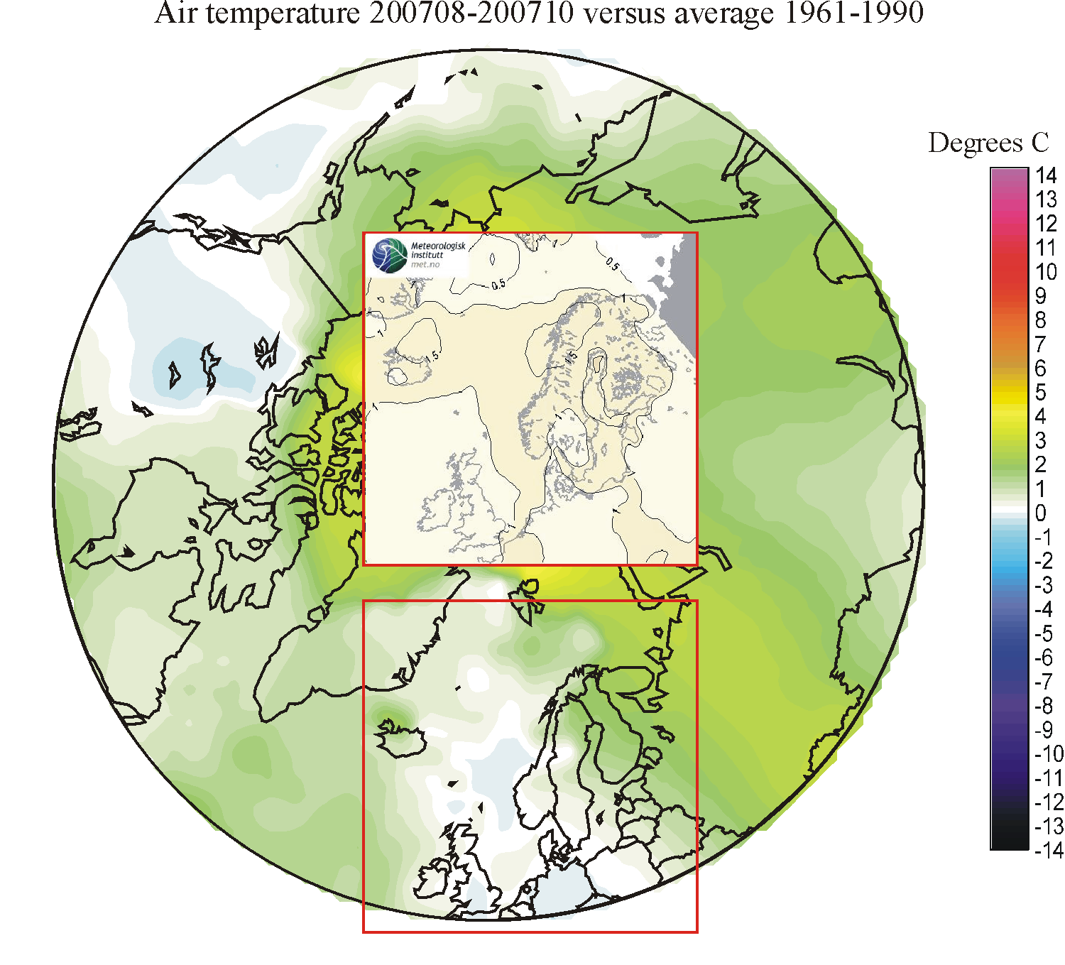
201110-201112: The forecast was quite satisfactory, with a good representation of the overall pattern: warm in the NE and cool in the SW of the study area.
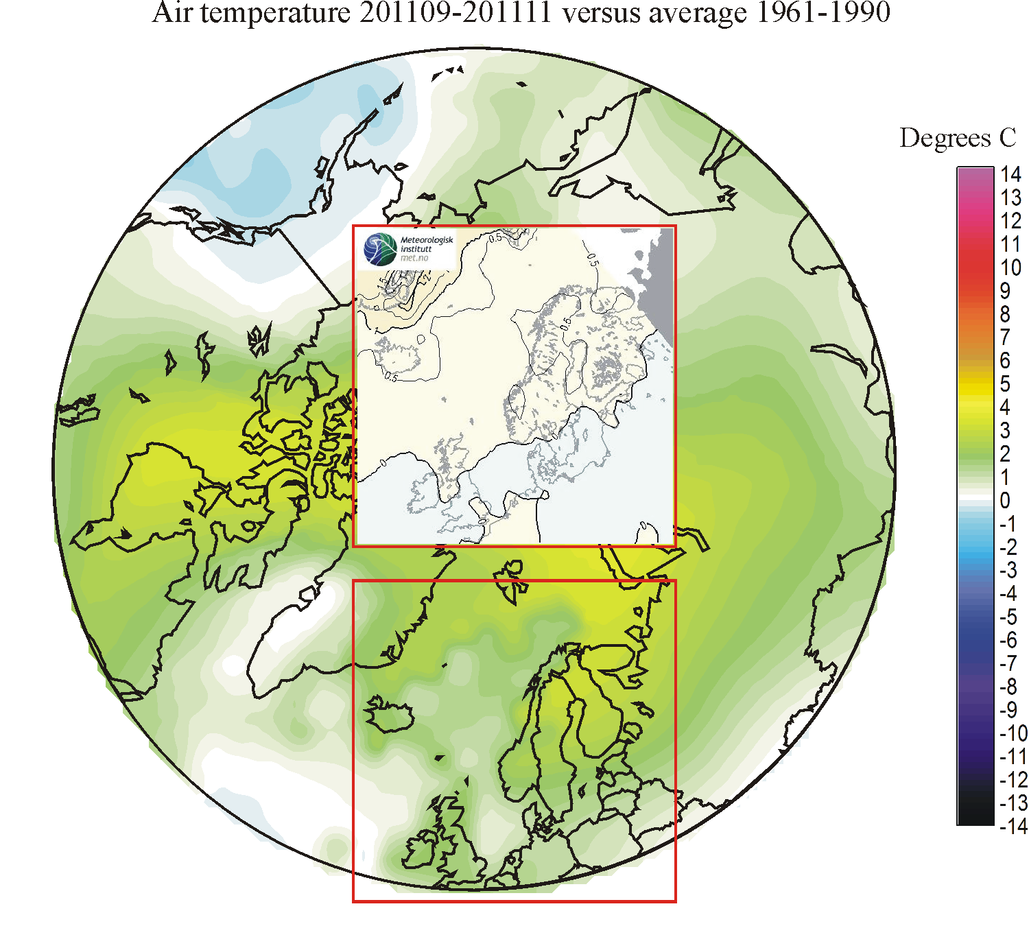
201109-201111: The forecast was relatively good as to the overall pattern, but with too small absolute temperature differences.
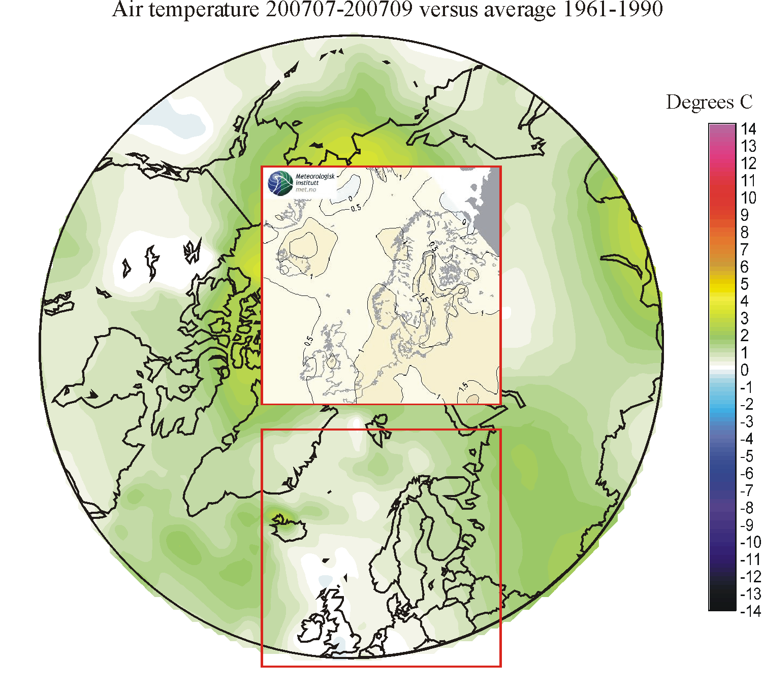
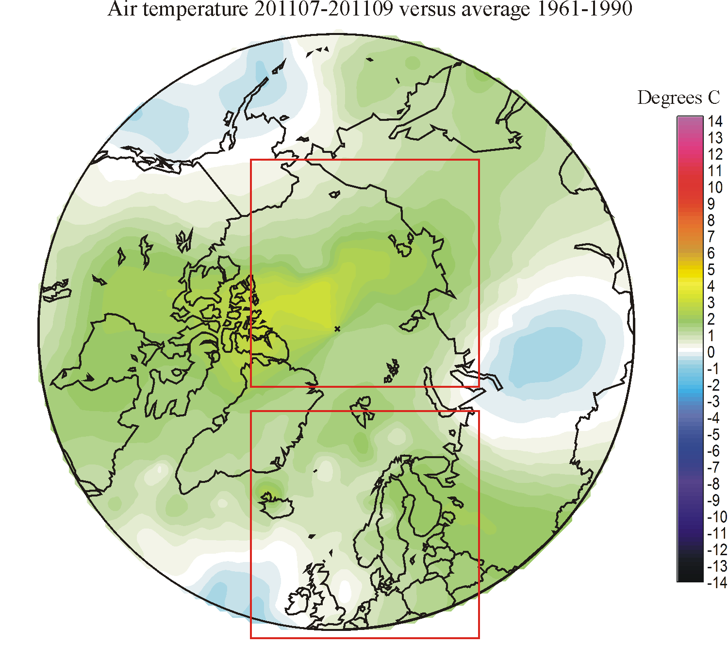
201108-201110: The forecast was quite satisfactory, with a good representation of the overall pattern: warm in the NE and cool in the SW of the study area.
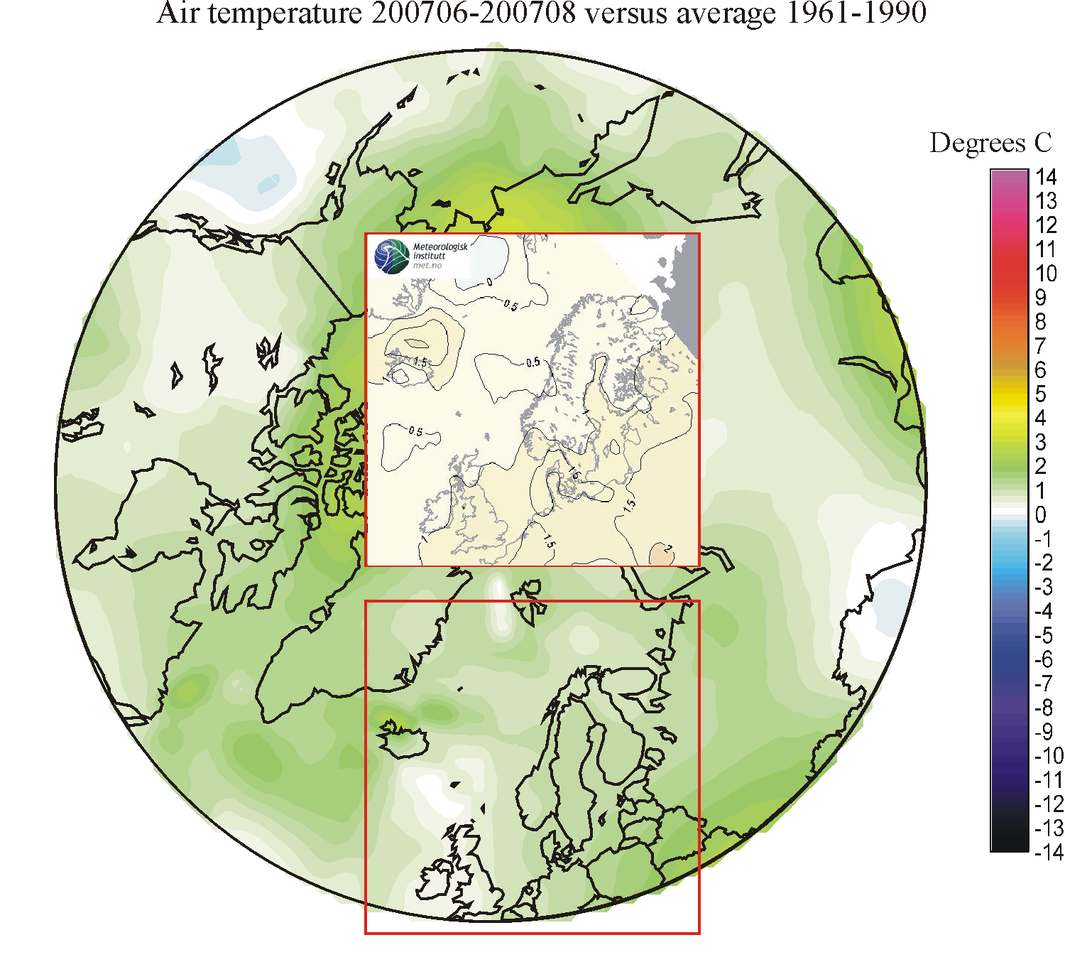
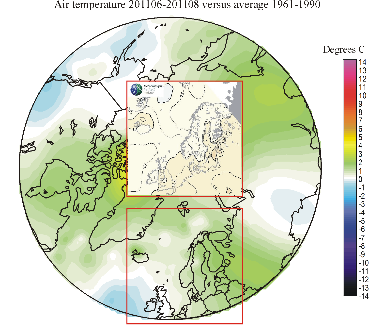
201106-201108: The forecast was good, with a fine fit for most areas.
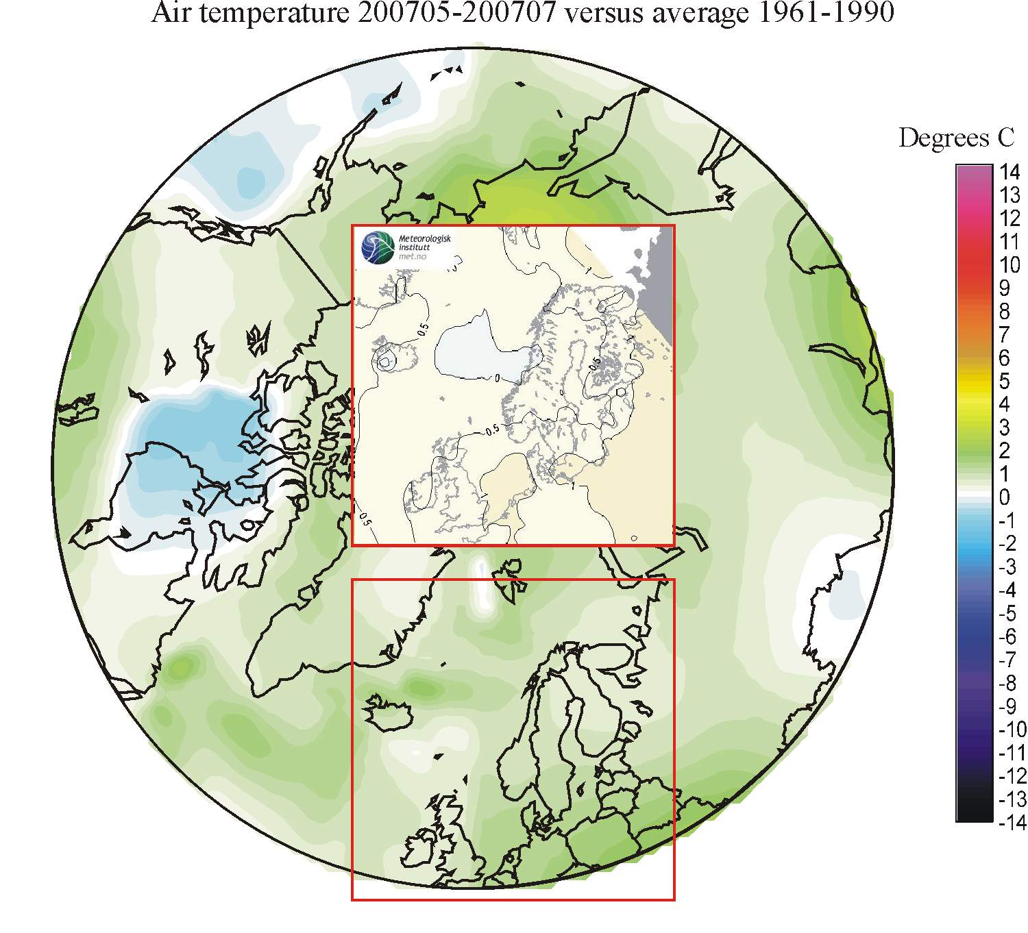
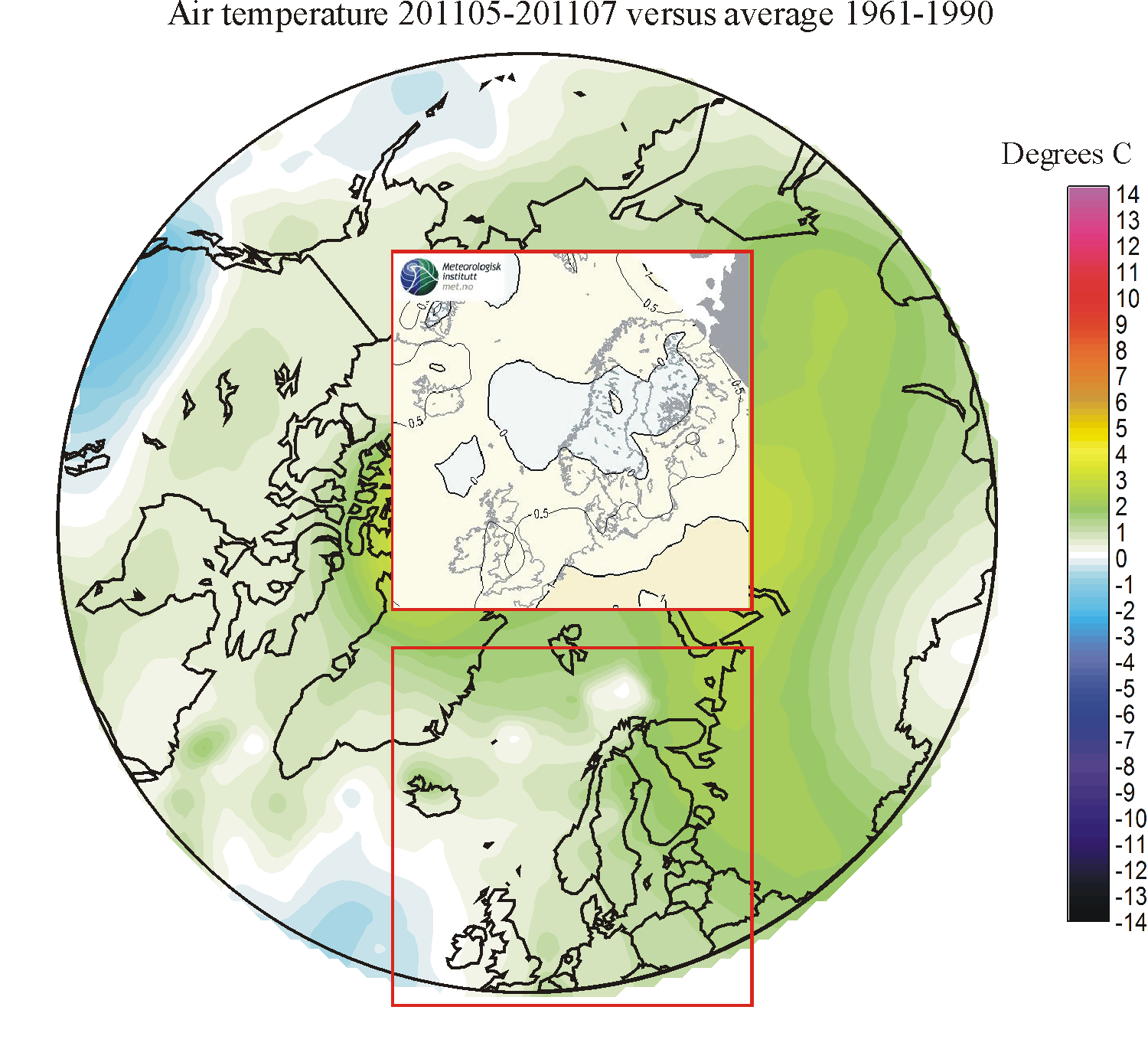
201105-201107: The forecast was neither very good nor bad. It was correct in forecasting relatively small summer temperature deviations, which usually is the case. On the other hand, the overall real temperature anomaly pattern was not satisfactory forecasted.
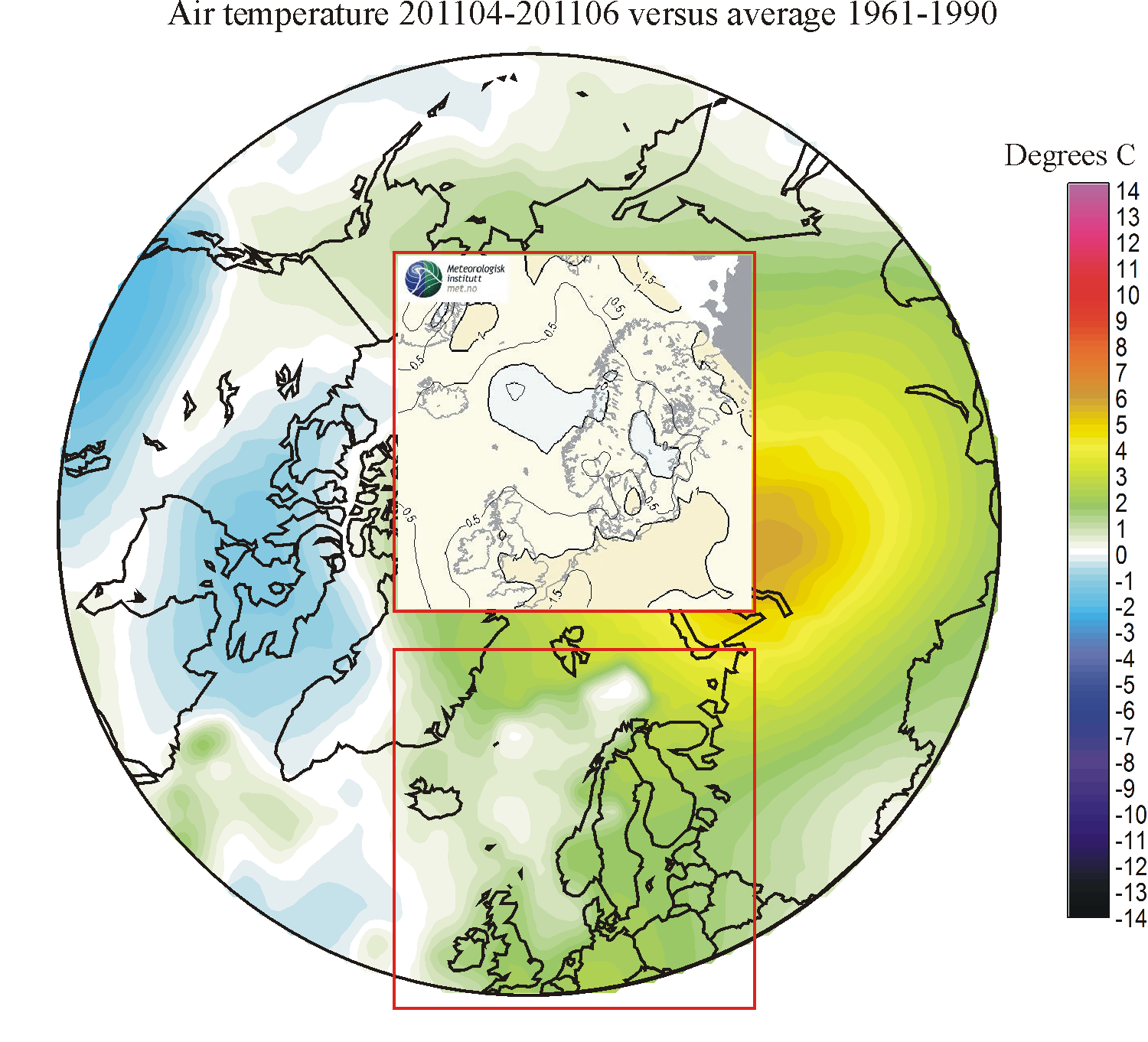
201104-201106: The forecast was good, with satisfactory fit for most areas.
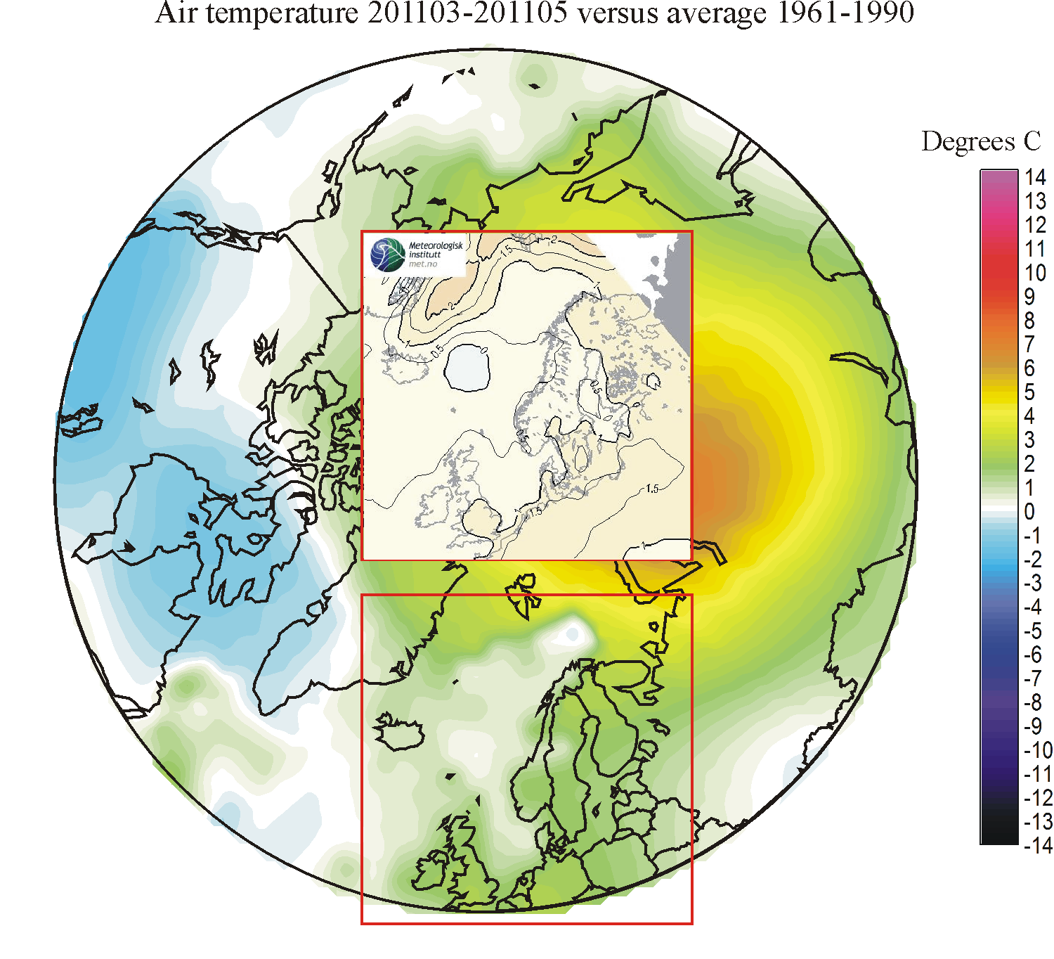
201103-201105: The forecast was fine, with good fit for most areas.
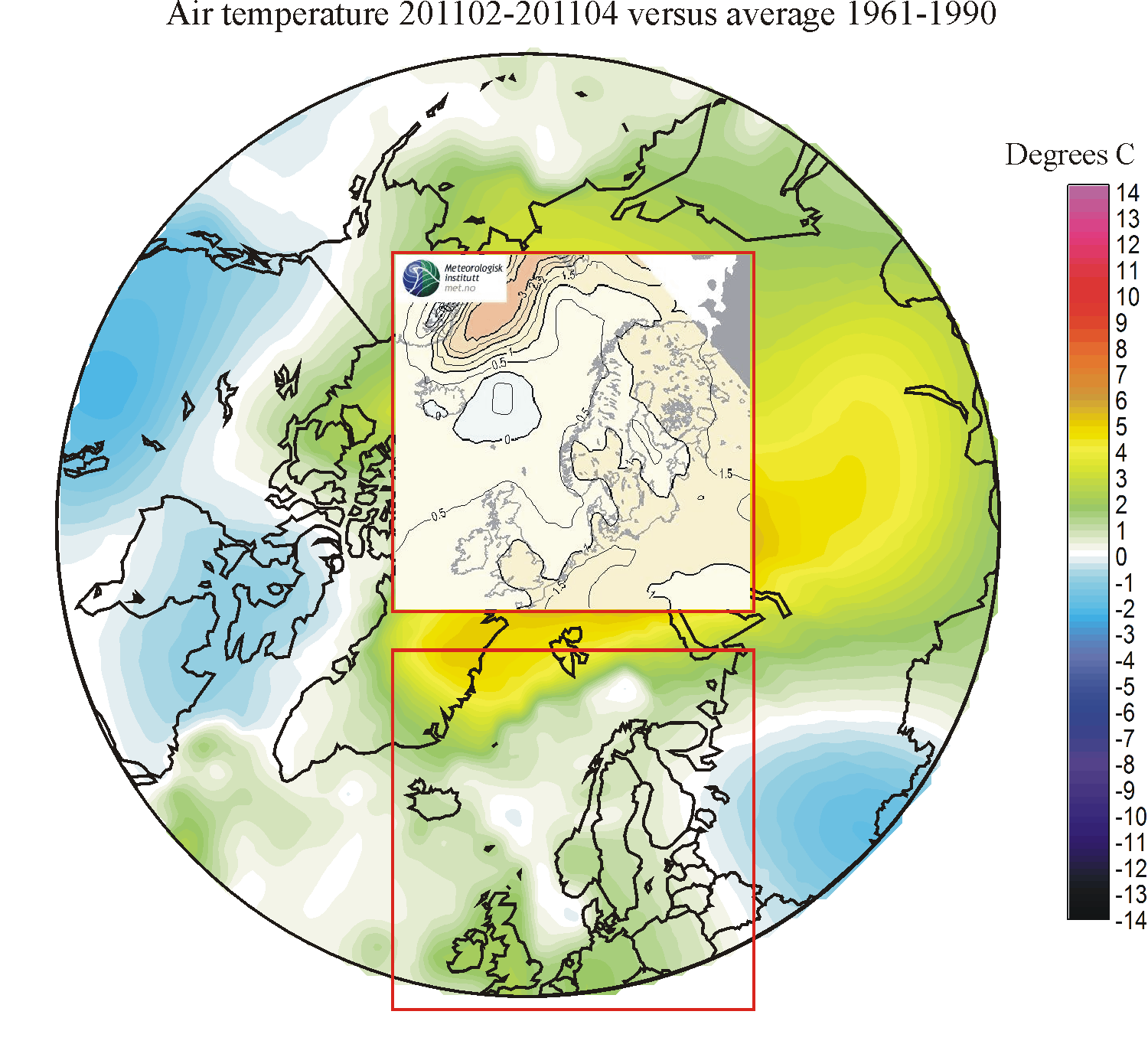
201102-201104: The forecast was fine, with good fit except for NW Russia, which instead of above average temperatures experienced below average temperatures.
201101-201103: The forecast was not entirely successful. Instead of enjoying above average 1961-1990 temperatures as forecasted, Northern Europe experienced colder conditions. Only for the sea along East Greenland the forecast turned out good.
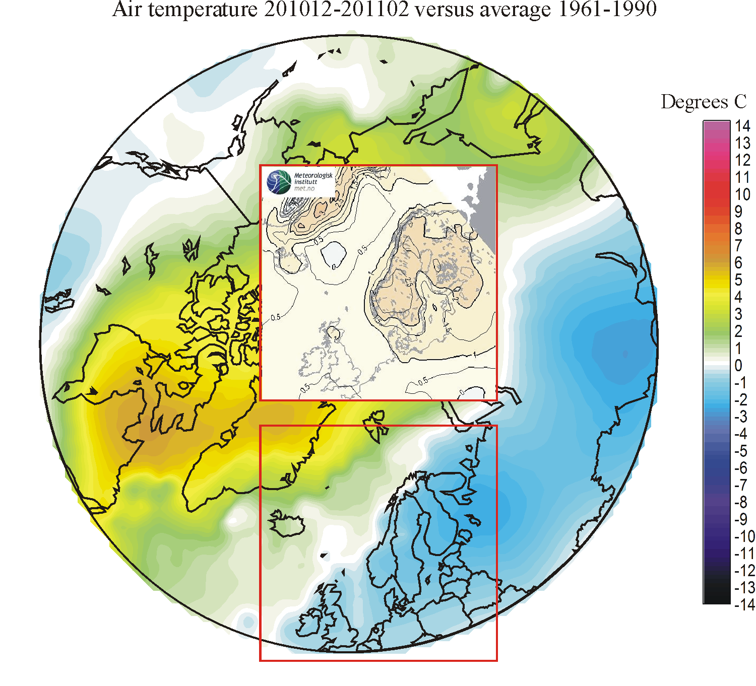
201012-201102: The forecast was not successful. Instead of enjoying above average 1961-1990 temperatures as forecasted, Northern Europe experienced below average temperatures. Especially for Denmark, Norway, Sweden and Finland the period turned out to be much colder than forecasted.
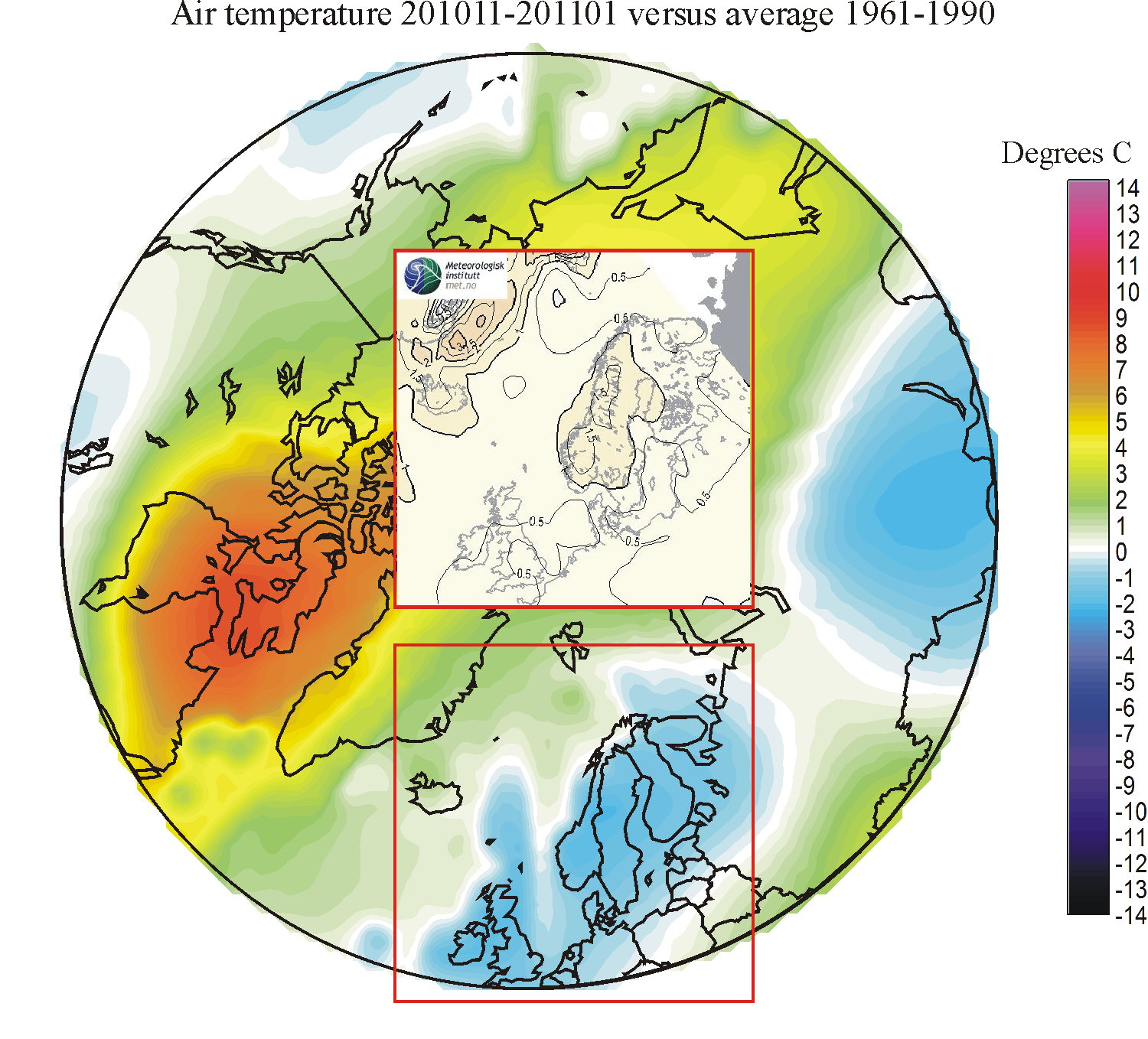
201011-201101: The forecast was not successful. Instead of enjoying above average 1961-1990 temperatures as forecasted, Northern Europe experienced below average temperatures.
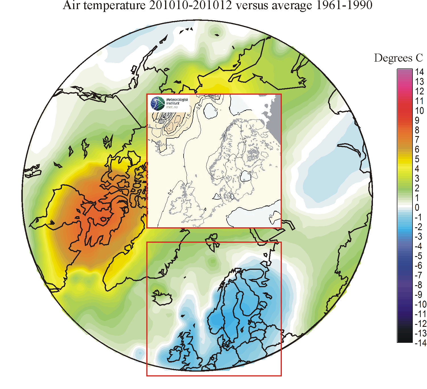
201010-201012: The forecast was not successful. Instead of enjoying above average 1961-1990 temperatures as forecasted, Northern Europe experienced below average temperatures.
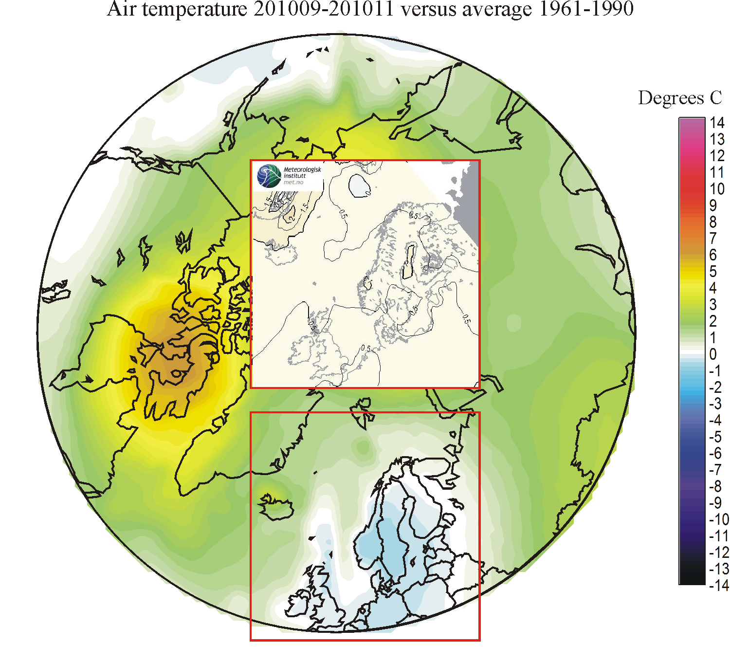
201009-201011: The forecast was not successful. Instead of enjoying above average 1961-1990 temperatures as forecasted, Northern Europe experienced below average temperatures.
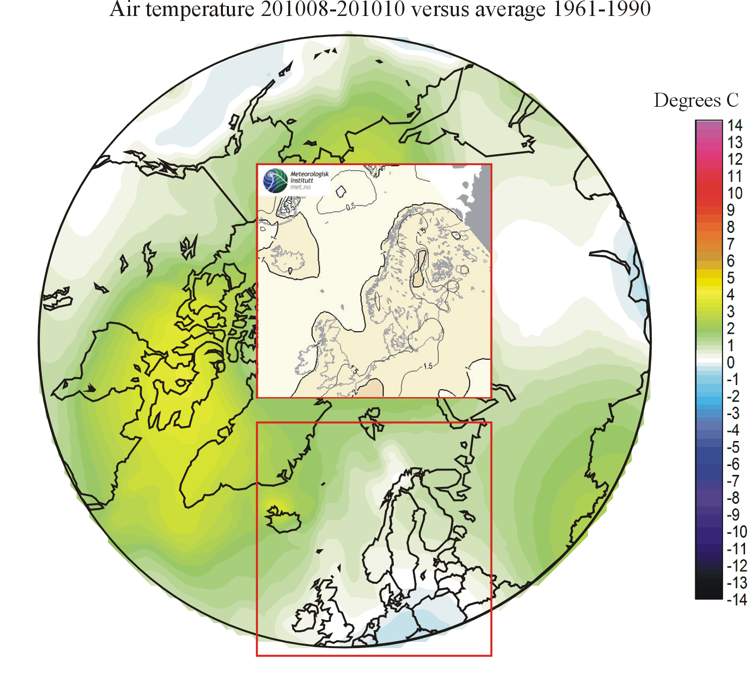
201008-201010: The forecast was not successful. A ridge of above 1961-1990 average temperatures extending SW-NE over NW Europe was forecasted. In reality, this turned out to be almost the opposite situation, with below average temperatures over Germany. The only successful part of the forecast was a small ridge of positive deviations from the 1961-1990 average extending from Iceland towards E Greenland.
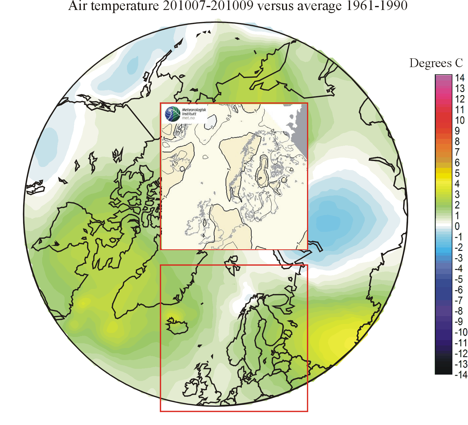
201007-201009: The forecast was correct in forecasting that, on average, the region considered would experience above 1961-1990 air temperatures. The geographical pattern of forecasted temperature anomalies, however, was not entirely satisfactory. Along western Norway a positive peak anomaly was forecasted. In reality, this turned out to be an area of minimum positive anomalies. Real maximum positive anomalies were found in the Iceland area (as forecasted) and over western Russia (not forecasted).
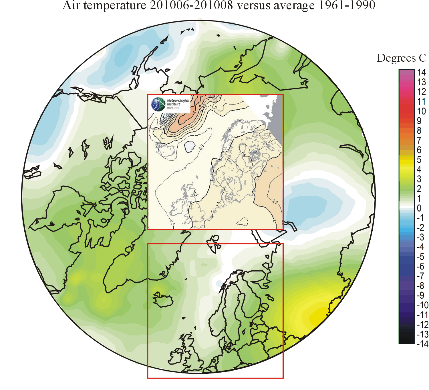
201006-201008: Again the forecast was good, but especially over land. A maximum of above average temperatures over southern western Russia was correctly forecasted. Over the Greenland Sea, however, the forecast failed to provide a correct picture.
201005-201007: The forecast was much better than during the preceding months. Warm conditions over especially western Russia was correctly forecasted.
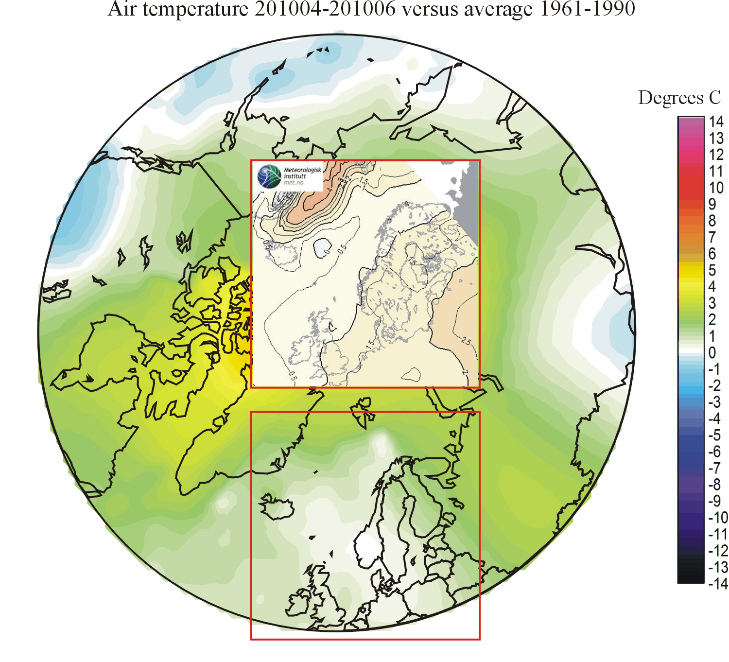
201004-201006: The forecast was not successful, even though it correctly forecasted above 1961-1990 average temperatures. More or less as was the case for the preceeding forecasting period (below), over northern Europe the general temperature configuration was about perpendicular to what was forecasted.
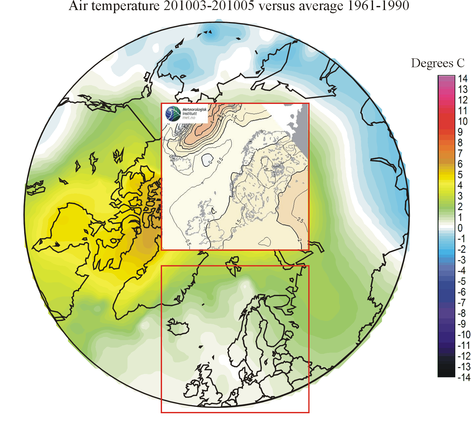
201003-201005: The forecast was not successful, especially for land areas. Over northern Europe the general temperature configuration was about perpendicular to what was forecasted. According to the forecast positive anomalies should increase toward southeastern Europe, while they in reality increased toward northern Russia.
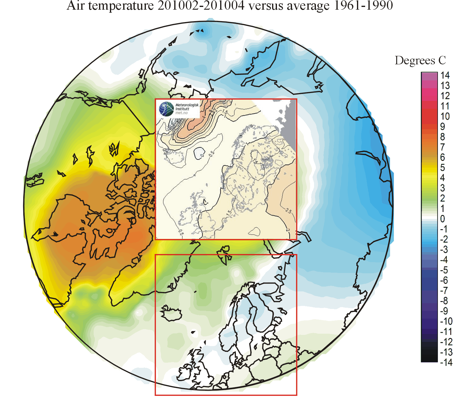
201002-201004: Again the forecast was very unsuccessful, especially for land areas. Northern Europe was forecasted to have above 1961-1990 average temperatures, but ended up having below average temperatures.
201001-201003: The forecast was highly unsuccessful, especially for land areas. Northern Europe was forecasted to have above 1961-1990 average temperatures, and increasing towards east. In reality the development was just opposite: Below average temperatures, and declining towards east.
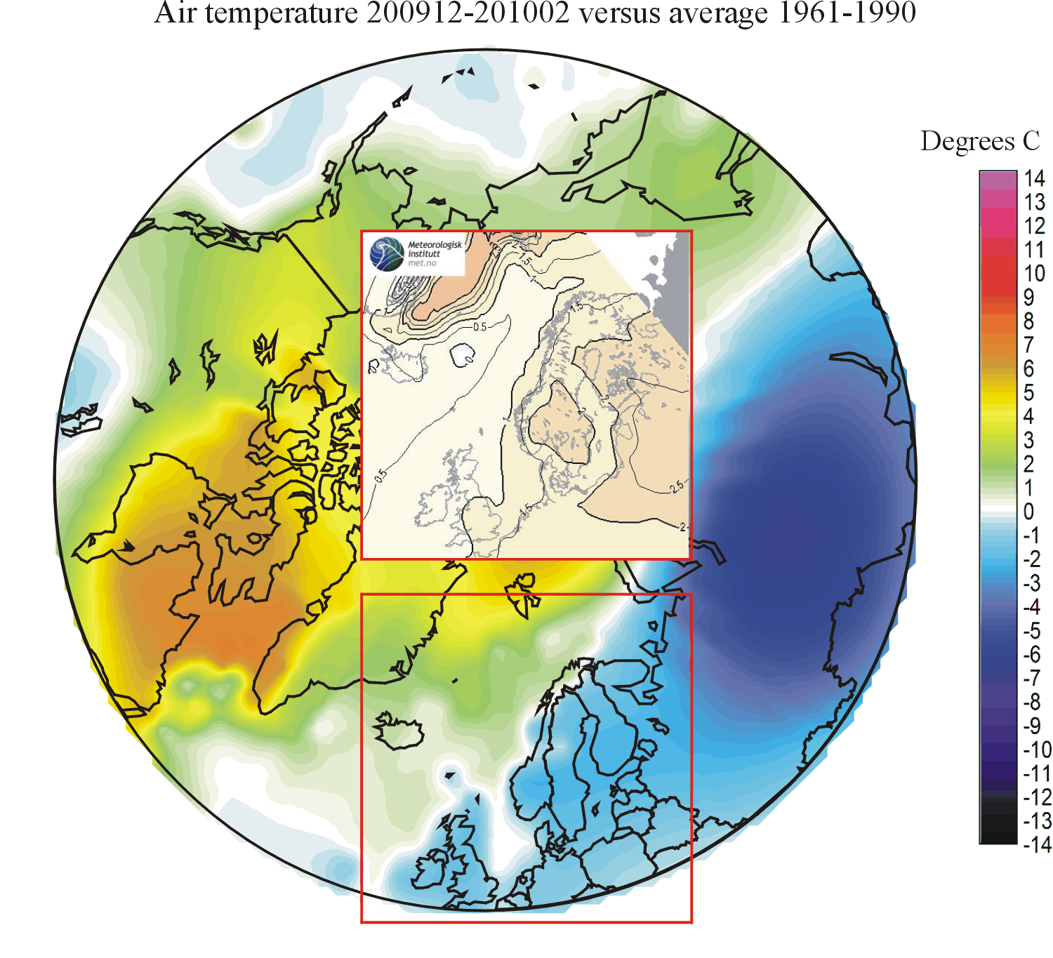
200912-201002: Again the forecast was not successful for land areas. Once again, the forecast for ocean regions turned out to be better than for land areas, most likely because of the much greater thermal inertia of oceans, compared to land areas. For the European land areas the forecast was far from good, as the forecasted positive thermal anomaly in the real world turned out to be a pronounced negative anomaly. The lack of forecasting success for this three-month period more or less turned out to be a repeat of the previous three-month forecast (see below).
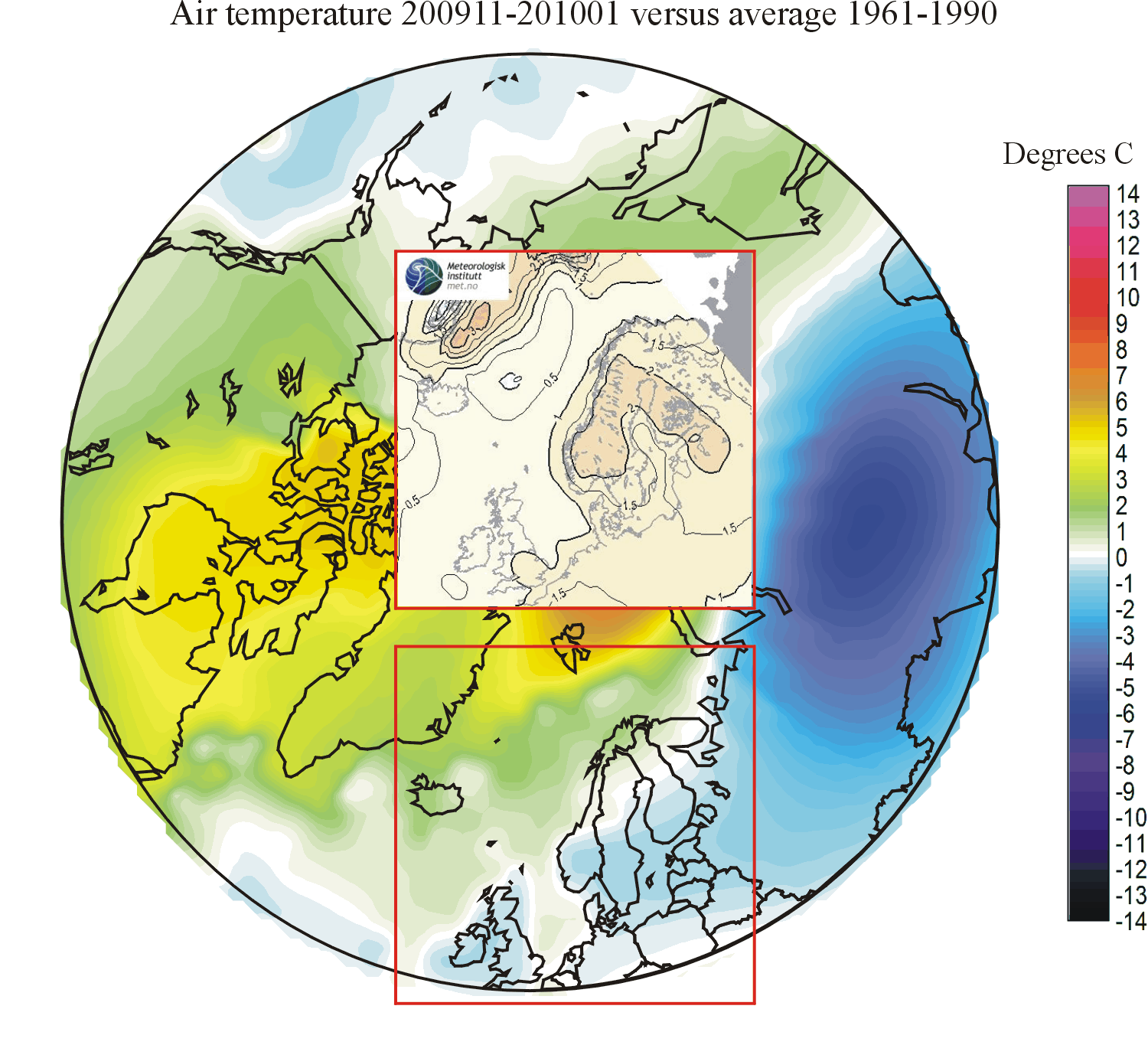
200911-201001: The forecast was not successful, especially for land areas. As seen before, the forecast for ocean regions is much better than for land areas, presumably because of the much greater thermal inertia of oceans, compared to land areas. For the European land areas the forecast was far from good, as the forecasted positive thermal anomaly in the real world turned out to be a pronounced negative anomaly.
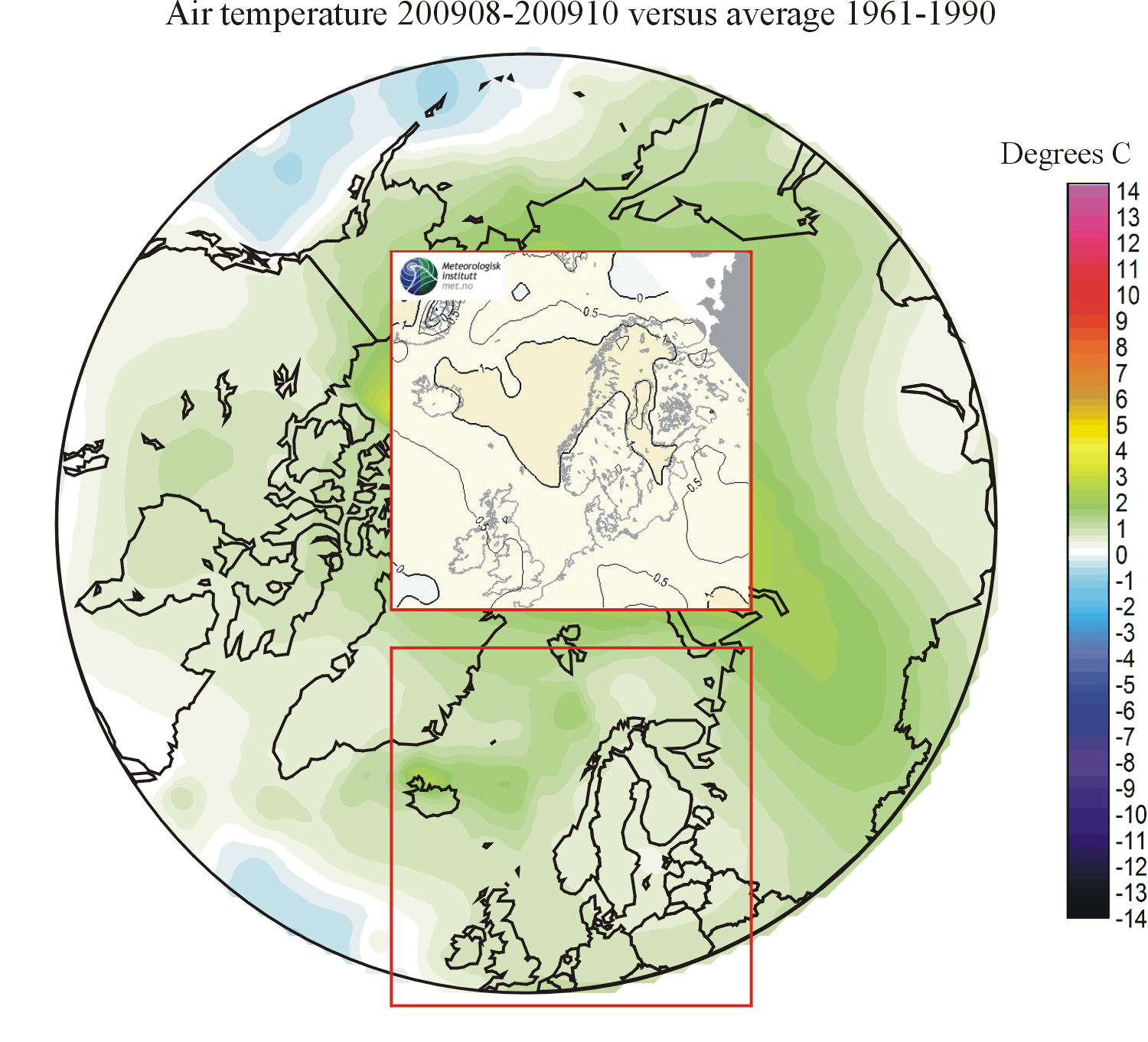
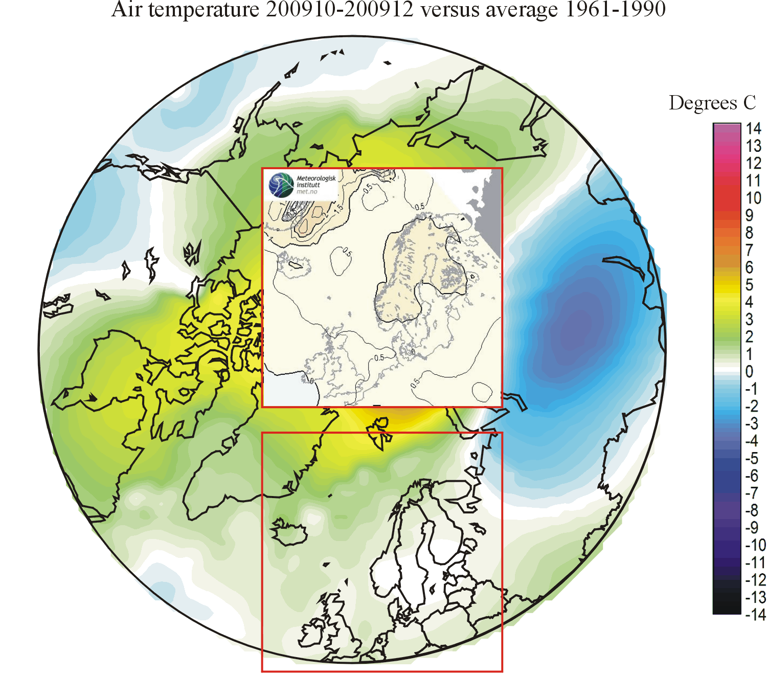
200910-200912: The forecast was not entirely successful. For eastern Greenland, Iceland and the Atlantic north of Iceland the forecast was quite good. Over Europe, however, there was disagreement between the forecasted and the measured temperatures. Temperatures were forecasted to be 0.5-1.0oC above the average 1961-1990. In reality, they turned out to be quite close to the 1961-1990 average. The disagreement in this part of the study area was mainly caused by one particular cold month, December 2009. As seen before, the forecast appear to be most successful for oceanic areas, and less so for land areas.
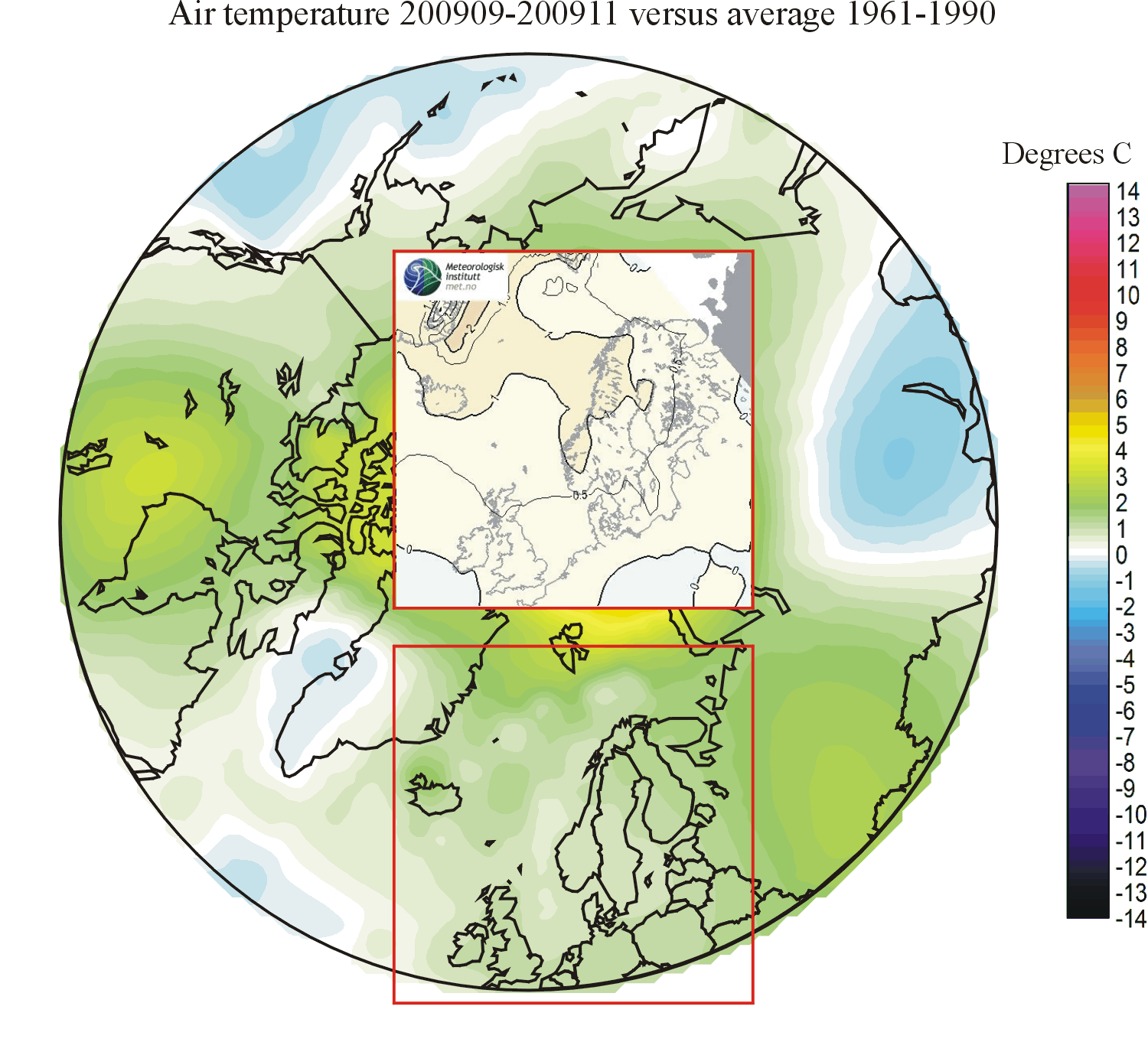
200909-200911: The forecast correctly indicated general positive surface air temperature anomalies over the study area. However, with regard to the spatial pattern of anomalies the forecast was less satisfactorily. The forecast indicated maximum positive temperature anomalies along a ridge between Norway and East Greenland, and from there decreasing towards more northerly latitudes. In the real world, the positive anomalies increased toward higher latitudes, with a region of maximum values located north of Svalbard.
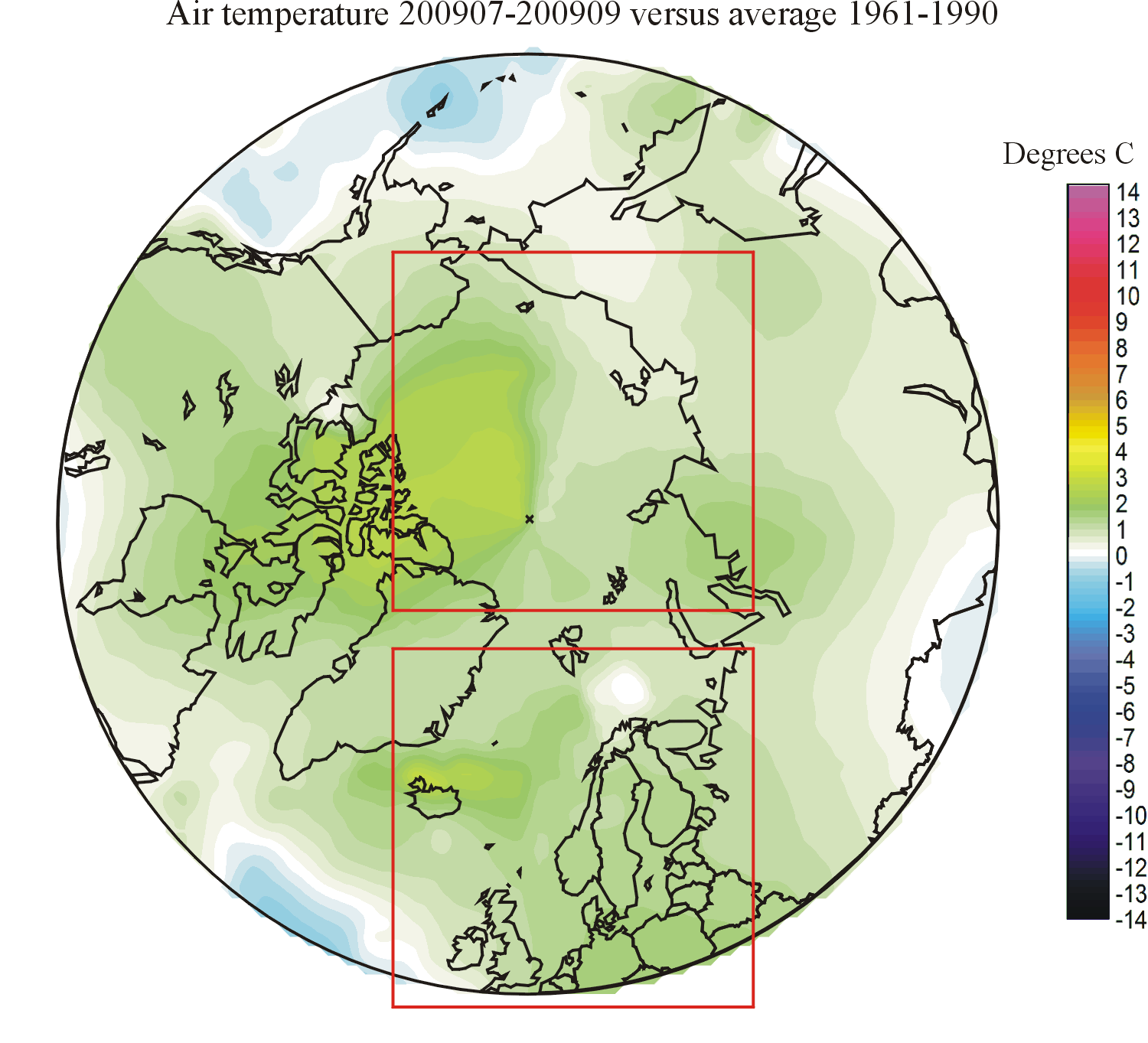
200908-200910: The forecast again was good with regard to both absolute values of temperature anomalies and the spatial pattern of recorded anomalies. Once again, the best fit between forecast and real world development is obtained for the ocean, while the fit is somewhat less for land.
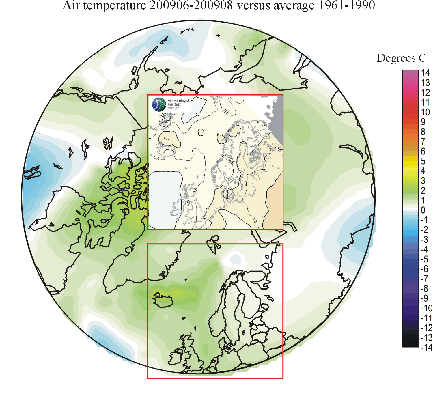
200906-200908: The forecast was good with respect to the overall configuration of temperature anomalies, especially over the ocean. Over land, the forecast deviates more from the real world development, where the forecasted maximum positive temperature anomaly over western Russia did not materialise.
200905-200907: The forecast was correct with regard to temperatures generally being above the 1961-1990 average. The actual geographical distribution of temperatures was, however, not successfully forecasted. The area forecasted area of warming was over Europe, while in reality this turned out to be the area of minimum warming.
200904-200906: The forecast was not successful. The area of cooling forecasted between western Norway and Iceland in reality was the axis of a ridge of relative warming across the North Atlantic. In short, the real world turned out to show more or less opposite changes, compared to what was forecasted for the study area.
200903-200905: The forecast was not extremely successful. The forecasted warming area along the east coast of Greenland and the cooling area over the sea around and north of Iceland did not show up in the real world result. Actually the pattern of warming in the real world was more or less opposite to the pattern forecasted. The forecasted relative warming for northern Europe was correct, but only in very general terms.
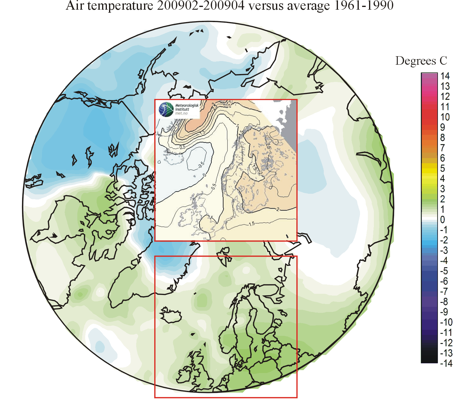
200902-200904: The forecast was not very successful. The overall configuration of relative warming and cooling areas within the geographical area considered was not well represented by the forecast. Along North-East Greenland, an area of forecasted above normal temperatures turned out to be an area of below normal temperatures. Likewise, around Iceland the area of forecasted below normal temperatures turned out to be an area of above normal temperatures. Over Europe, temperatures were forecasted to be above the average for 1961-1900, which turned out to be correct. The general configuration of isotherms within this part of the study area was, however, not very well forecasted.
200901-200903: The forecast was satisfactory. The overall configuration of relative warming and cooling areas within the geographical area considered was well described by the forecast. Real world warming along East Greenland and over southern UK, Germany and Denmark was, however, smaller than forecasted.
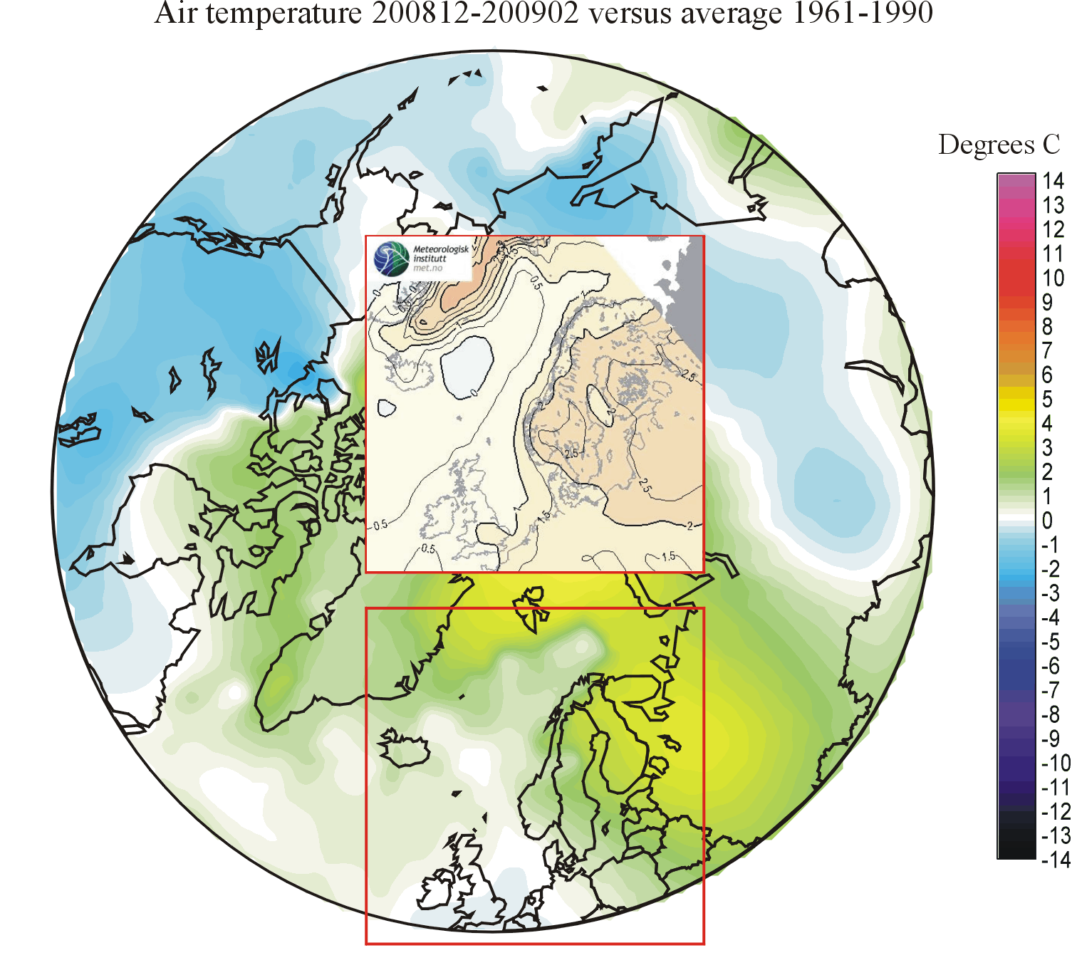
200812-200902: The forecast was excellent. The overall configuration of relative warming and cooling areas within the geographical area considered was well described by the forecast.
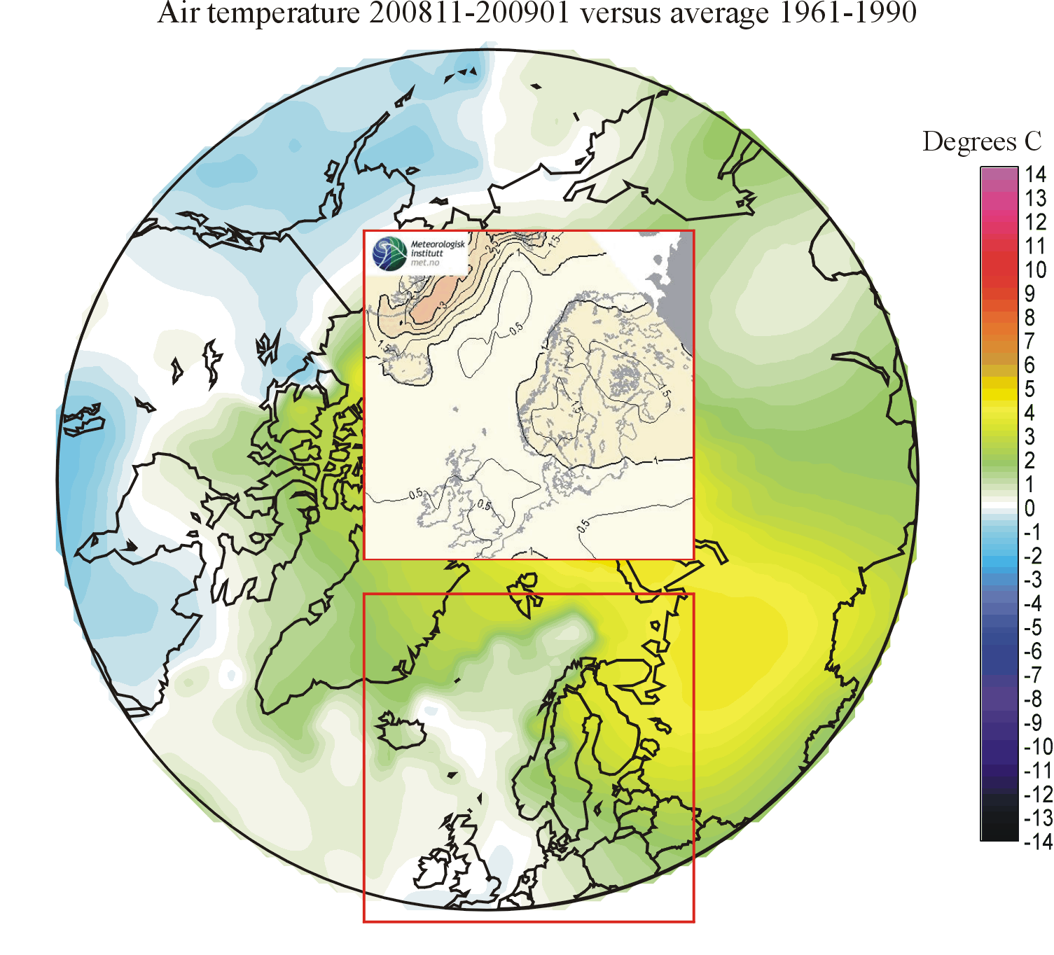
200811-200901: The forecast was good. The warming along East Greenland was overestimated, and the warming over the Nordic countries was underestimated, but the forecast was excellent as to the overall configuration of relative warming and cooling areas within the geographical area considered.
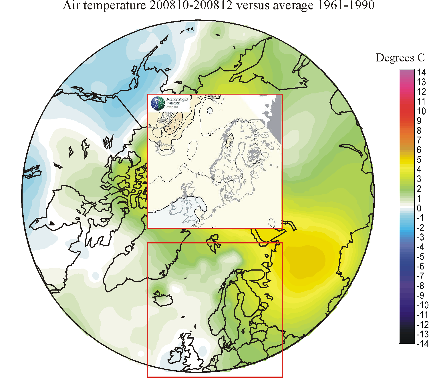
200810-200812: The forecast was only partly successful. The intensive warming forecasted for areas along eastern Greenland is not shown by the observations. Perhaps, this might be caused by the forecast assuming a significant reduction of seal ice along East Greenland, which did not take place? An area of general warming was forecasted to cover the region from East Greenland towards central Scandinavia. Instead warming turned out to characterise the northeastern part of the study area. The forecast is, however, satisfactorily when it comes to the temperature development over UK and Ireland, and adjoining parts of the North Atlantic. In general, as in previous forecasting periods, the forecast works better for the ocean than for the land areas. This might be due to the larger thermal thermal inertia of the ocean, compared to the land areas.
200809-200811: The forecast was satisfactorily for the ocean north of Iceland, but the forecasted warming along East Greenland was to high. For the rest of the forecasting area cooling was expected to dominate towards east, but in reality this became an area of positive temperature anomalies. A small area of cooling is seen near the SW corner of the study area, although not forecasted in this position.
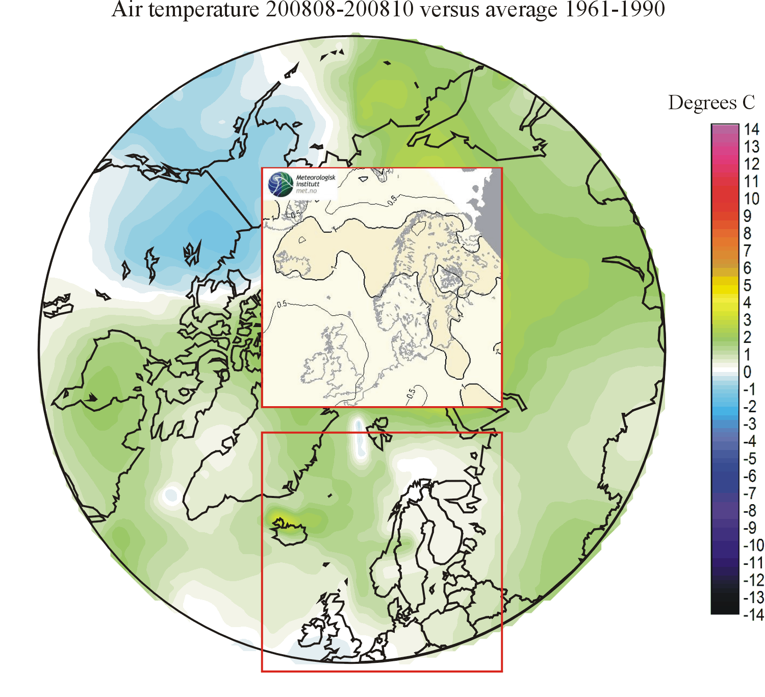
200808-200810: The forecast was satisfactorily for the ocean north of Iceland, where a ridge of relative high temperatures extends between Norway and East Greenland. The forecast is, however, less satisfactory for the land areas. Southern UK and Ireland was exposed to below average 1961-1991 temperatures, in contrast to the forecast. Also the temperature contrast between the northern and southern parts of the Nordic countries is in contrast to the forecast for the period. During the last months the forecasting model has performed better above the ocean than in the terrestrial environment. The higher thermal inertia of the oceans may perhaps contribute to this, making it more easy to forecast future (three-month) temperature changes over the ocean, compared to the land surface?
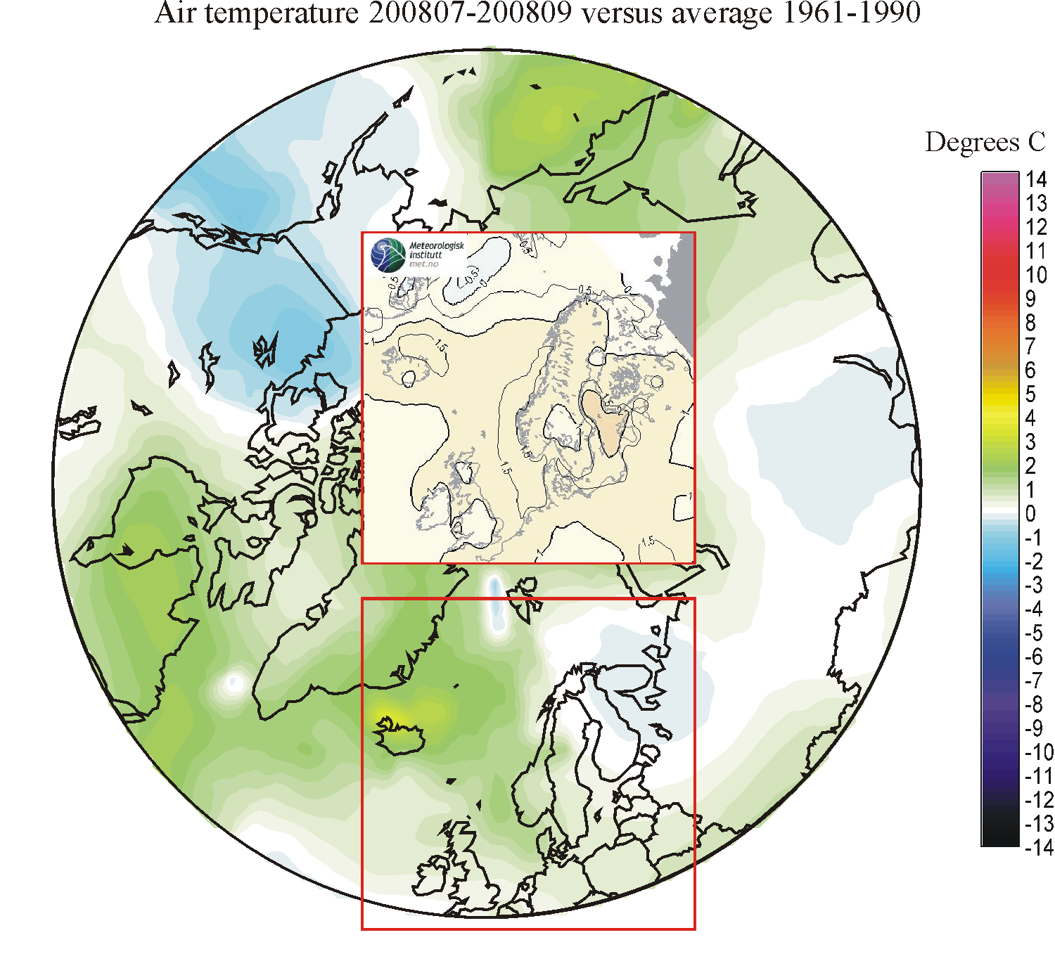
200807-200809: The forecast is good for the marine part of the North Atlantic region, where a ridge of relative warming is seen extending from the North See towards East Greenland. Over terrestrial Europe, however, the forecast is less satisfactory. The North Atlantic area of warming was forecasted to extend across most of North Europe. This turned out not to be the case with the exception of southwestern Norway. In reality most of the land areas experienced only small temperature changes compared to 1961-1990, and easternmost Finland and NW Russia actually experienced relative cooling.
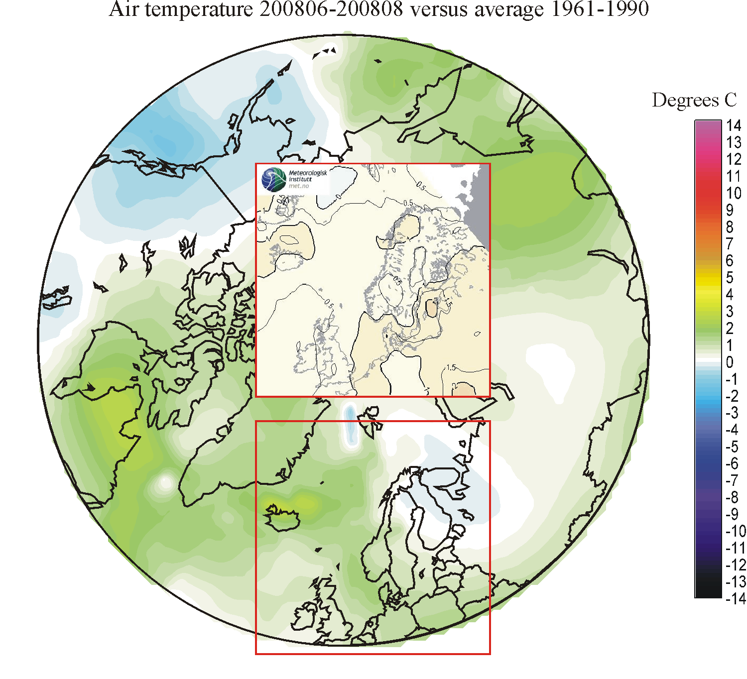
200806-200808: The forecast is good, when compared to the real development. The warm ridge extending from Denmark towards the sea north of Iceland is correctly forecasted, including the warm peak north of Iceland. The local cooling region southwest of Svalbard is also shown in the forecast. The forecast is less satisfactory for northeastern part of the geographical region considered, where small changes or even slight cooling was experienced. The general impression remains, however, of a successful forecast.
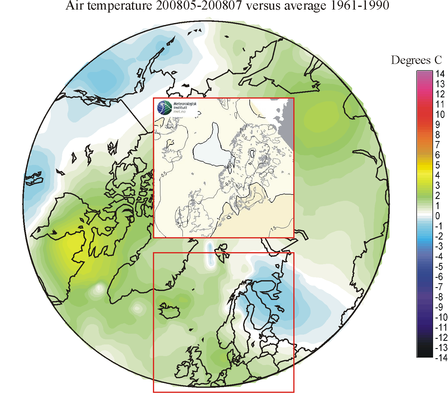
200805-200807: The forecast is not entirely satisfactory when compared to the real development. Especially the negative temperature anomaly over northern Scandinavia, Finland and NW Russia was not forecasted at all. The maximum warm anomaly forecasted for northern Germany did not come true, either. The North Sea and the region north of Iceland instead showed the maximum positive temperature anomaly.
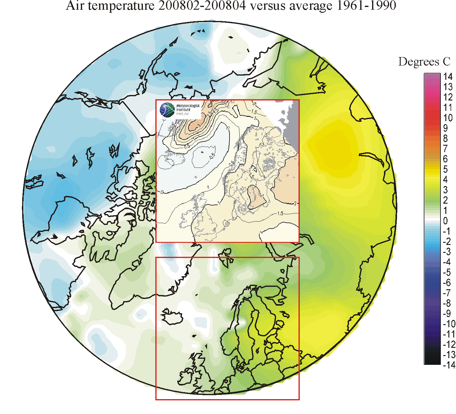
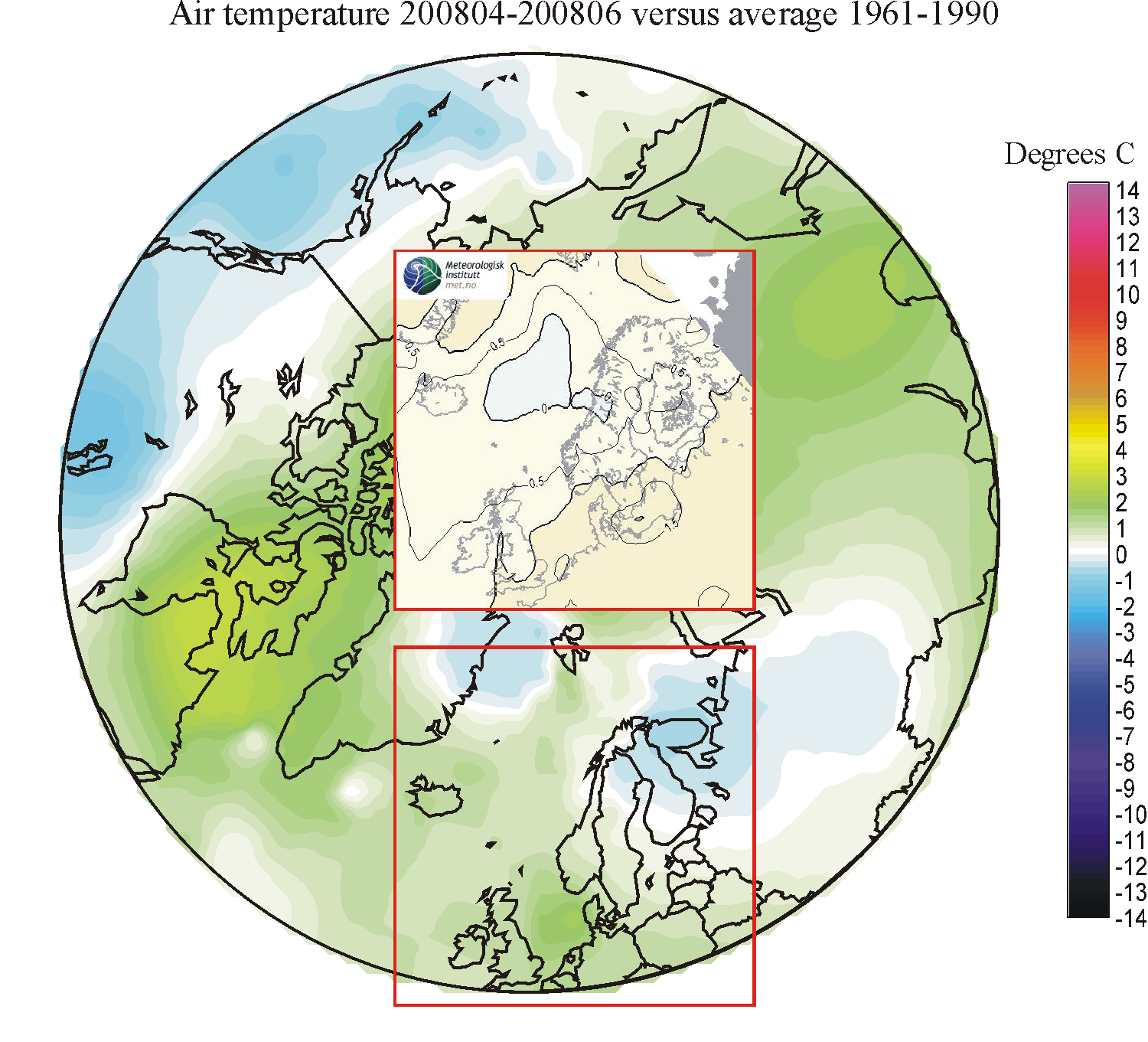
200804-200806: For UK and Denmark the fit is satisfactory, although not perfect. For northern Scandinavia, the North Atlantic north of Iceland and along East Greenland, however, the forecast was opposite to the real temperature change recorded.
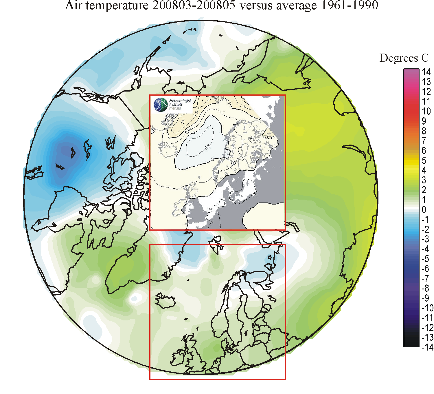
200803-200805: Agreement between the seasonal MAM-forcast and the real development within the UK-Denmark region is good. However, the forecast for Greenland, Greenland Sea, Norwegian Sea and the Barents Sea was not good. In these regions the real temperature change was opposite to that forecasted.
200902-200904: Good fit for NW Europe and the Barents Sea. Bad fit for the Greenland Sea and East Greenland.
200901-200903: Good fit for NW Europe and the Barents Sea. Bad fit for the Greenland Sea and East Greenland.
200812-200902: Satisfactory fit for NW Europe and the Barents Sea, but warming in NW Russia is underestimated. Less satisfactory fit for the Greenland Sea and East Greenland.
200811-200901: Satisfactory fit for NW Europe but warming in NW Russia and in the Barents Sea is underestimated. Moderate fit for the Greenland Sea and East Greenland, where warming is overestimated.
200810-200812: Moderate fit. Warming in the regions from Svalbard to NW Russia is underestimated.
200809-200811: Unsatisfactory fit. Cooling over central Europe is not forecasted. Warming in the Barents Sea is not forecasted. Along East Greenland warming is forecasted, which is in contrast to the 'normal' conditions recorded.
200808-200810: Unsatisfactory fit. Moderate warming is forecasted for the a region across the North Atlantic extending from central Norway across Iceland to East Greenland. Observations show this region to be near or slightly below 'normal' conditions, while NW Russia and the Barents Sea region experienced warming.
Click here to jump back to the list of content.