Longyearbyen UHI experiment, April 28, 2008
Open Climate4you homepage
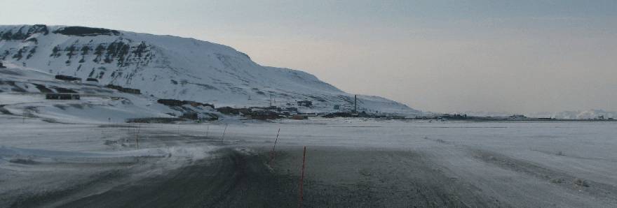
Longyearbyen April 28, 2008
15:09 hr (not corrected for summer time), looking WNW from the northern end of
the lake Isdammen (see map below). The sky was partially covered by high, thin
clouds. The wind
was strong from southeast, 8-12 m/s. The large building in the
distance to the right is the main hangar at Svalbard Ariport. Compare with map below.
The general weather
situation, measurement equipment and measurement route
The air temperature was about -3oC, and the wind strong from southeast, 8-12 m/s, but with local deviations (see map below). The sky was partially covered by high, thin clouds. The ground surface was covered by snow. The nearby fjord was partly ice free, with the exception of the innermost 1000 m and the northern half, which was covered by ice. A shielded thermistor was attached to the roof of a car (c. 1.5 m above terrain), and temperatures were logged at 2 sec. intervals. The time given in the diagrams below are not corrected for summer time. The measurements were carried starting at Svalbard Airport in the upper left of the map below, driving southeast along the coast to the town, making a roundtour here, before proceding southeast into the lower part of the large valley Adventdalen.
Longyearbyen
is the worlds northernmost town and is located at 78o17'N 11o20'E,
in central
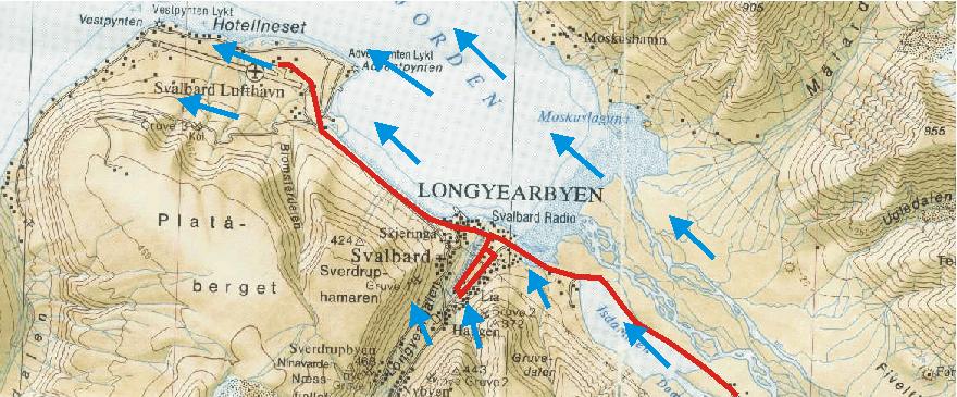
Topographic map showing Longyearbyen and Svalbard Airport (Svalbard Lufthavn). The red line shows the measurement route April 28, 2008, starting at the Airport and ending in the lower part of the valley Adventdalen to the SE. In between, a detour was made in the central part of the town as shown. The wind was strong, 8-12 m/s, from southeast, but with local deviations (blue arrows). The fjord was ice free, except for the northern part, which was filled with ice. The map section measures c. 13 km west to east.
Results
Result
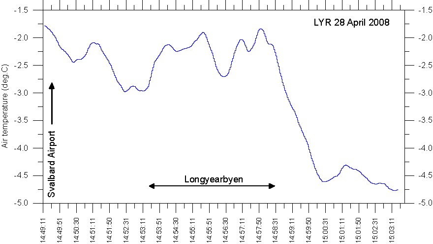
of temperature measurements along the route Svalbard Airport - Longyearbyen
-Adventdalen, April 28, 2008. The official Svalbard meteorological station is
located at the airport. Se map above for reference.
Interpretation of results
The whole area was snowcovered. Parts of the route were sunlit, while others were in topographic shade. Because of thin, high clouds, the sun was veak.
The registered air temperatures show an overall falling trend towards southeast along the main measurement route. Near the airport, where the official Svalbard meteorological station is located, air temperatures are relatively high (about -1.7oC), which is interpreted as the result of the onshore airflow from southeast across the ice free fjord. Further towards southeast, this local warming effect rapidly diminishes inland, and colder air (about -4.7oC) draining out along the valley Adventdalen dominates. The temperature difference between the Airport and Adventdalen is about 3oC, representing the open water effect (OWE) at this particular time. The OWE is reduced compared to previous situations with southeasterly air flow (see e.g. the experiment 20080331), where the difference between air and sea water was larger, and the OWE therefore more important. In between the Airport and Adventdalen, the local heat island effect of the town Longyearbyen is clearly seen. The maximum UHI effect appears to be about 1oC at the time of the experiment. The wind speed was somewhat lower in Longyeardalen, about 6-8 m/s, than in the larger and more exposed valley Adventdalen.
The
existence of an urban heat island effect in a relatively small settlement
as Longyearbyen may come as a surprise. This is, however, not the first
time this has been observed in the Arctic; see, e.g., Hinkel
et al. 2003.