Longyearbyen UHI experiment, July 17, 2008
Open Climate4you homepage
Longyearbyen July 17, 2008
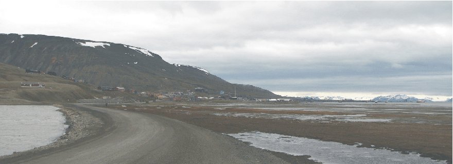
09:42 hr (not corrected for summer time), looking WNW from the northern end of
the lake Isdammen (see map below). The sky was overcast. The wind
was fresh from southeast, 6-8 m/s. The large building in the
distance to the right is the main hangar at Svalbard Ariport. Compare with map below.
The general weather
situation, measurement equipment and measurement route
The air temperature was about 8oC, and the wind fresh from southeast, 6-8 m/s, but with local deviations (see map below). The sky was overcast. The ground surface was free of snow, except for snow patches in the higher ground (see photo above). The nearby fjord was ice free. A shielded thermistor was attached to the roof of a car (c. 1.5 m above terrain), and temperatures were logged at 2 sec. intervals. The time given in the diagrams below are not corrected for summer time. The measurements were carried starting at Svalbard Airport in the upper left of the map below, driving southeast along the coast to the town, making a roundtour here, before proceding southeast into the lower part of the large valley Adventdalen.
Longyearbyen
is the worlds northernmost town and is located at 78o17'N 11o20'E,
in central
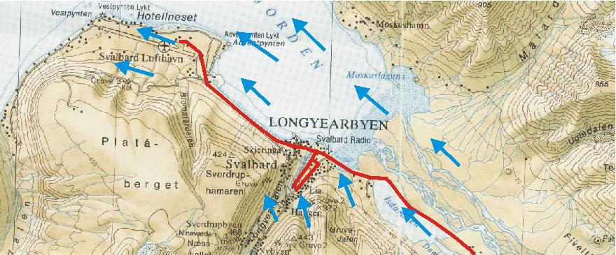
Topographic map showing Longyearbyen and Svalbard Airport (Svalbard Lufthavn). The red line shows the measurement route July 17, 2008, starting at the Airport (location of the official meteorological station) and ending in the lower part of the valley Adventdalen to the SE. In between, a detour was made in the central part of the town as shown. The wind was generally fresh, 6-8 m/s, from southeast, but weak in the valley where Longyearbyen is located (blue arrows). The fjord was ice free. The map section measures c. 13 km west to east.
Results
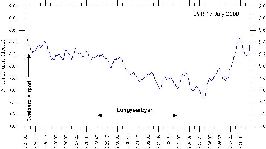
Result
of temperature measurements along the route Svalbard Airport - Longyearbyen
-Adventdalen, July 17, 2008. The official Svalbard meteorological station is
located at the airport. Se map above for reference.
Interpretation of results
Near sea level the landscape was generally free of snow and the regional snow line was at about 500 m asl. The route was in shade from direct solar insolation because of the overcast conditions. A low was located shortly west of northern Norway, giving rise to easterly airflow across Svalbard. On the lee side of the mountains, this resulted in a foehn-effect with relatively warm and dry airmasses flowing in westerly direction along the main fjords and valleys.
The measured air temperatures show an overall falling trend towards southeast into the village Longyearbyen. In Adventdalen air temperatures again show an increasing trend towards southeast, along with the measurement position again being more exposed to the fresh southeasterly airflow. Near the airport, where the official Svalbard meteorological station is located, air temperatures was relatively high (about 8.5oC), which is interpreted as the meteorological station being influenced by relatively warm air (the foehn effect) draining out of Adventdalen. In Longyearbyen, the air flow was weak, and therefore not much influenced by the foehn effect. The temperature difference between the Airport and Longyearbyen is about 1oC, representing the topographic control on areas influenced by the foehn effect and areas not affected to the same degree.