Longyearbyen UHI experiment, July 27, 2008
Open Climate4you homepage
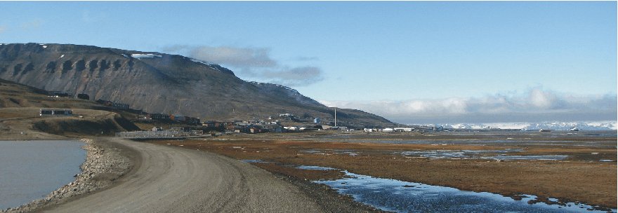
Longyearbyen July 27, 2008
12:12 hr (not corrected for summer time), looking WNW from the northern end of
the lake Isdammen (see map below). The sky was overcast. The wind
was from northwest, 7-9 m/s. The large building in the
distance to the right is the main hangar at Svalbard Ariport. Compare with map below.
The general weather
situation, measurement equipment and measurement route
The air temperature was about 9oC, and the wind from northwest, 7-9 m/s, but with local deviations (see map below). The sky clear with the exception of some orographic clouds along mountains. The ground surface was free of snow, except for snow patches in the higher ground (see photo above). The nearby fjord was ice free. A shielded thermistor was attached to the roof of a car (c. 1.5 m above terrain), and temperatures were logged at 2 sec. intervals. The time given in the diagrams below are not corrected for summer time. The measurements were carried starting at Svalbard Airport in the upper left of the map below, driving southeast along the coast to the town, making a roundtour here, before proceding southeast into the lower part of the large valley Adventdalen.
Longyearbyen
is the worlds northernmost town and is located at 78o17'N 11o20'E,
in central
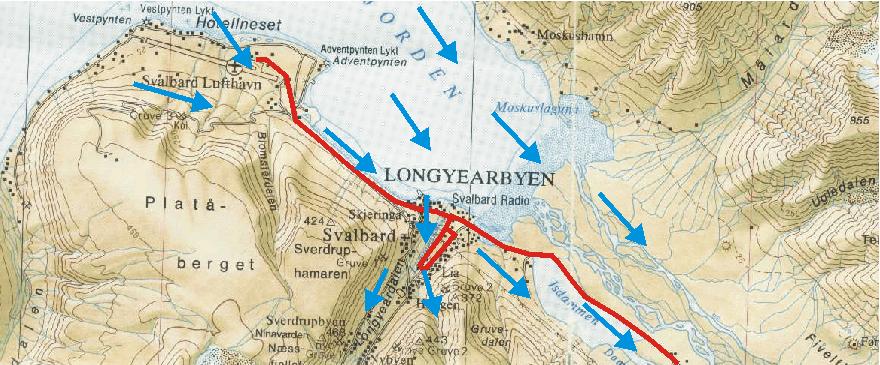
Topographic map showing Longyearbyen and Svalbard Airport (Svalbard Lufthavn). The red line shows the measurement route July 27, 2008, starting at the Airport (location of the official meteorological station) and ending in the lower part of the valley Adventdalen to the SE. In between, a detour was made in the central part of the town as shown. The wind generally was from northwest, 7-9 m/s., but in Longyearvalley the airflow turned south, controlled by the topography (blue arrows). The fjord was ice free. The map section measures c. 13 km west to east.
Results
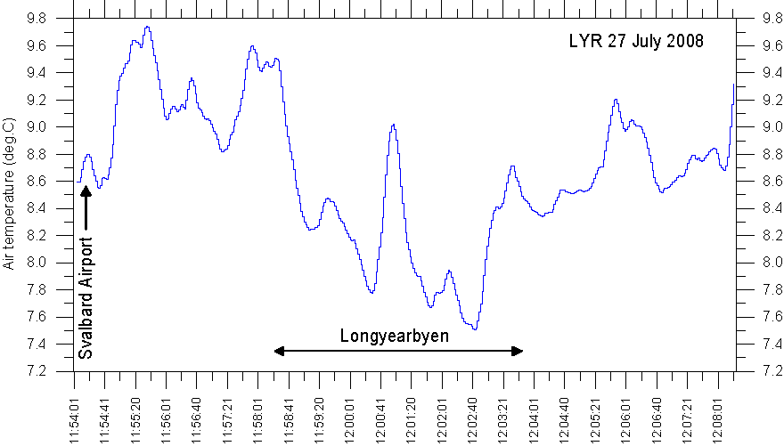
Result
of temperature measurements along the route Svalbard Airport - Longyearbyen
-Adventdalen, July 27, 2008. The official Svalbard meteorological station is
located at the airport. Se map above for reference.
Interpretation of results
Near sea level the
landscape was generally free of snow and the regional snow line was at about 570
m asl. The route was sunlit and not shaded by topography or clouds at any point.
Leaving the Airport,
the recorded air temperatures first show increasing temperatures from c. 8.6oC
to c. 9.6oC, followed by a decrease towards Longyearbyen, reaching a
minimum of c. 7.5oC in the northern part of the settlement.
Travelling inland along Adventdalen, air temperatures again increase to about 9oC.
The local about 2oC
variation in air temperature is ascribed to the combined effects of wind and the
nearby ocean. The official meteorological station at the airport was located at
border between relatively warm air masses flowing across sunlit terrain north of
Platå-berget, and relatively cold air flowing onshore from the sea (see map
above). Further towards Longyearbyen, the measurement route was within air
masses warmed by flowing across several kilometres of sunlit, snow-free ground.
Near Longyearbyen air masses were turned flowing up valley in Longyeardalen by
the topography, wherefore Longyearbyen was exposed to relatively cold, onshore
airflow from the nearby fjord. Only in the southern part of Longyearbyen where
the wind strength decreased somewhat and buildings provided additional lee, the
air temperature increased from 7.8oC to about 9oC within a
short distance. Further inland in the major valley Adventdalen, air masses
flowing from the fjord were warmed by the sunlit ground surface, and air
temperatures gradually again climbed to about 9oC. The freshwater
reservoir Isdammen is seen to have a local cooling effect on the air
temperatures recorded.