Year 1600-1699 AD
-
1600: Glacier Vernagtferner advances into valley Rofental and creates an ice dammed lake
-
1602: Storm closes the natural harbour at Saksun, Faeroe Islands
-
1613: Inuit (Eskimo) found in kayak near Hull, eastern England
-
1658: Swedish iceborne invasion of Denmark; the Treaty of Roskilde
-
1678: Vernagtferner in Austria again advances into Rofental and forms an ice dammed lake
-
1682-1684: Inuit landings on Orkney Islands, northern Scotland
1600: Glacier Vernagtferner advances into valley Rofental and creates an ice dammed lake
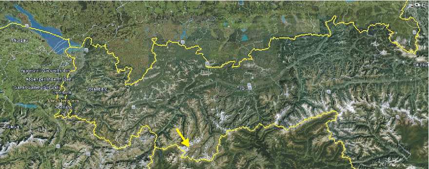
Satlellite photo showing western Austria with the location of Vernagtferner (arrow). Picture source: Google Earth.
The glacier Vernagtferner in the Ötztaler Alps in western Austria is famous for its repeated advances during the Little Ice Age, partly because some of the advances were rapid and surge-like, partly because the glacier at times managed to advance into a main valley, Rofental, blocking drainage from upvalley sources, and thereby creating a big ice dammed lake (Richter 1892, Hoinkes 1969, Humlum 1974).
This
ice dammed lake (named Rofener Eissee; engl. Rofen Ice Lake) first
time formed in 1600 and was suddenly drained below the blocking glacier tounge
on July 20, 1600. The drainage was catastrophic, just like a jö
Rofener
Eissee in July 1601 (Painting by Abraham Jä
Later Little Ice Age advances of the Vernagtferner, leading to formation and drainage of the ice dammed Rofener Eissee is described here, here and here. Click here, here and here to read about the glacier retreat following the Little Ice Age advances.
Click here to jump back to the list of contents.
1600-1800:
Land abandonment in southeast Scotland
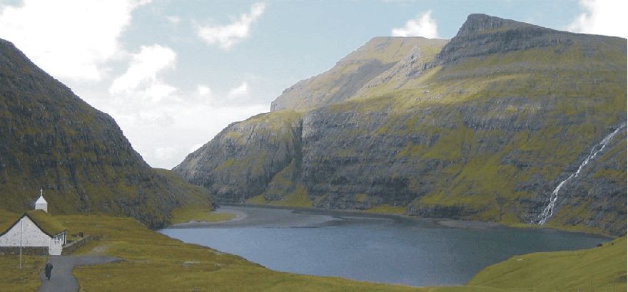
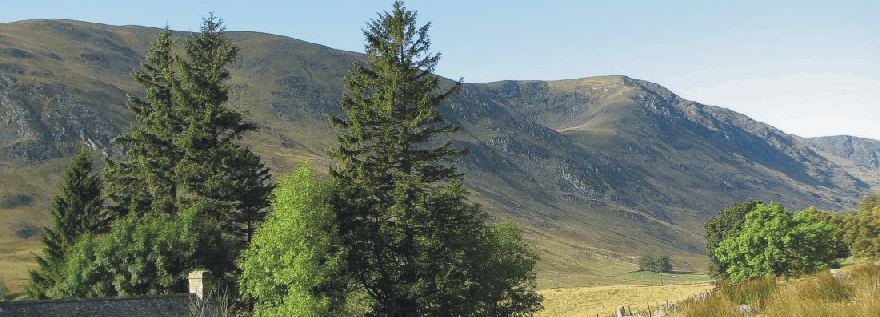
Moulzie farm (290 m asl.) in uppermost Glen Clova, Angus, Scotland, May 7, 2008. At this altitude only grass can be grown and harvested in the early 21st century.
In southeast
In Britain, oats grown above 250 m altitude are known to be sensitive to summer warmth, exposure and summer wetness, which may be measured in terms of accumulated temperature, average wind speed and end-of-summer potential water surplus (Parry 1975).
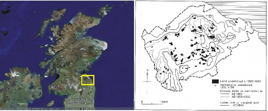
Sattelite picture showing Scotland with Lammermuir Hills indicated (left). Map over Lammermuir Hills showing farmland abandoned and lowered climatic limits to cultivation 1600-1800. Small circles show settlements abandoned 1600-1750 (Parry 1975; right).
In the Lammermuir Hills in southeastern Scotland, minimum levels of summer warmth for the ripening of oats have been established to be 1050 degree-days above a base of 4.4oC, and maximum tolerable levels of the other two limiting factors 6.2 m/s average wind speed and 60 mm potential water surplus (Parry 1975, 1976). It is estimated that if, over the period 1250-1450, the mean annual air temperature fell a little less than 1oC, then summer warmth at 300 m altitude in northern England would have been reduced by 15 per cent. The frequency of crop failure would increase sevenfold from 1 year in 20 to 1 year in 3, and the frequency of two consecutive crop failures increased 70 times.
The processes involved in land abandonment can be better understood if changes in climate are considered in terms of changes in frequency of short-term anomalous events (Grove 1988). Such events affect the level of risk faced by the farmer. The viability of farmland essentially depends on its ability to sustain the household from one harvest to the next. The extent to which yield exceeds this essential minimum is less important than the likelihood of achieving the minimum in a given year, and the probability of harvest failure is more important than average yield over a number of years. Harvest failure in two successive years, leading to the consumption of the seed grain or the exhaustion of cash reserves, is likely to be disastrous.
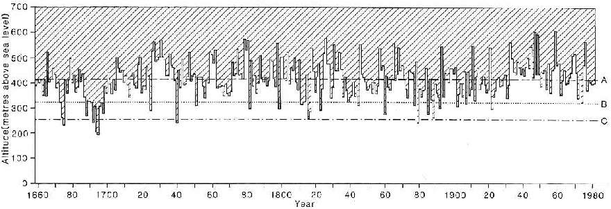
Hypothetical shift of oat crop
failure with altitude in southern
In maritime upland areas, quite small increases in altitude commonly result in marked shortening of the growing season and a great reduction in the accumulated warmth as measured in degree-days above a certain temperature (Manley 1945). Click here to see an example of this from the 20th century. Parry and Carter (1985) evaluated the risk of crop failure resulting from low levels of accumulated temperature in the Lammermuir Hills, southeastern Scotland, using data for the period 1659-1981 from central England (Manley 1974) compared with meteorological observations at Edinburgh and a network of 27 stations covering the Southern Uplands. As the regionally averaged lapse rate of air temperature with elevation is known to be 0.68oC per 100 m, the height at which the minimum accumulated temperature for ripening of oats of 970 degree-days is achieved each year could be calculated (see figure above). It is seen that while the critical altitude for ripening of oats was about 450 m above sea level during the warm period around 1940, this critical altitude was depressed to about 250-300 m during the cold period 1685-1700.
Click here to jump back to the list of contents.
1602: Storm closes the natural harbour at Saksun, Faeroe Islands
The former fine natural harbour at Saksun, NW Streymoy, Faeroe Islands. The direction of view is towards west. The entrance to the open ocean can clearly be seen, as can the sand bank accumulated by large waves in the entrance during the great storm 2 February 1602. The sand bank has since grown by the accumulation of windblown (aeolian) sand (today partly overgrown). The Saksun Church is seen in the left foreground, located on top of Kvíggjarhamar mentioned in the text below. Photo taken July 13, 2002.
February 2, 1602, the Faeroe Islands are hit by a great storm, today still remembered as the hard Kyndelmisse. The storm permanently destroyed the famous sheltered natural harbour at Saksun in NW Faeroe Islands, on the west coast of the main island Streymoy. Great waves pouring in through the narrow entrance channel blocked the natural harbour with sand (Lamb 1977; Guttesen 1992). Short time after the storm a Dutch merchant ship arrived, commanded by Captain Kjálkin. As usual, he steered for the entrance to the harbour, but ran firmly aground on the sand bank (pers. comm. R. Guttesen 2003). Captain Kjálkin's storage house still exists at Saksun, located below the steep rock slope leading up to Kvíggjarhamar (see photo above).
Further south on Streymoy at Kirkjubø, the sea went across the peninsula Kirkjubøhólmur, on which the church was located. The resulting erosion must have been considerable, at the outermost part of the former peninsula today is an island, separated from the mainland by a 150 m broad sound.
Click here to jump back to the list of contents.
1613: Inuit (Eskimo) found in kayak near Hull, eastern England
In 1613 a dead Inuit (Eskimo) was found drifting in his kayak in the North Sea, outside Hull. This particular kayak had a skeleton consisting of bones (Mikkelsen 1954).
Click here to jump back to the list of contents.
1619-1620: Jens Munk's attempt at the North-West Passage
Jens Munk's ships in the Hudson Strait (left). Jens Munk's winter harbour in the mouth of the Churchill River, Hudson Bay, where he and his 64 companions were struck down by disastrously by scurvy in the early months of 1620 (centre). Hudson Bay seen from the SE, with the yellow arrow indicating the position of Jens Munk's winter harbour at Churchill River (right). Picture source: Google Earth. Greenland can be seen in the upper right.
Jens
Munk's childhood was spent in southern
In
1619 Christian IV ordered Jens Munk to find the
Sailing
southwestwards across
The
lack of vitamin-C resulted in the sailors' worse fear: an outbreak of scurvy.
This spread quickly and lethally among the crews. And when the ice finally
opened, in June 1620, there were only Jens Munk and two others survivors left.
Incredibly, these three men managed to sail one of the vessels across the
Atlantic to Norway, which they reached at the end of September 1620. In Bergen
Jens Munk was thrown in jail but was later paroled, by order of the king, and
was able to return to Copenhagen around Christmas 1620.
Jens
Munk later became an admiral in the Danish-Norwegian fleet, and served until his
death in the summer of 1628. Despite the failures of his attempt at the
1634: The Nordstrand flood of 1634 AD
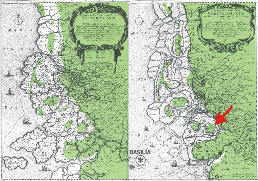
Geography
of southern Denmark and northern Germany, showing (left) the coastal outline in
1240 AD, and (right) the outline in 1651 AD, both maps compiled by
Johannes Mejerus. The green area shows the modern outline of land. The red arrow
shows the location of the island Nordstrand.
Each map covers about 95 km from west to east. Map source: Pedersen
(1977).
Nordstrand
is one of the many Frisian islands extending all the way from the Netherlands to
southern Denmark, with the islands north of the German Bight known as the North
Frisian Islands. Until the German-Austrian-Danish
war in 1864, all these islands were part of Denmark.
As
can be seen from the map above, Nordstrand in the recent past was part of a much
more extensive land area, extending far west into the present North Sea (Pedersen,
1977).
Slow
regional tectonic sinking in combination with the overall Holocene global sea
level rise have caused a large-scale flooding of land areas in this region of
Europe over the past 9000 years. Just about 8000 years ago, most of the present
North Sea was dry land, with the northern coast extending roughly from Hanstholm
in NW Denmark towards Edinburgh in Scotland.
From time to time, periods with frequent strong storms have contributed to this gradual loss of land areas, as can be illustrated by outlining the main features of the large flood in the Nordstrand area in the year 1634.
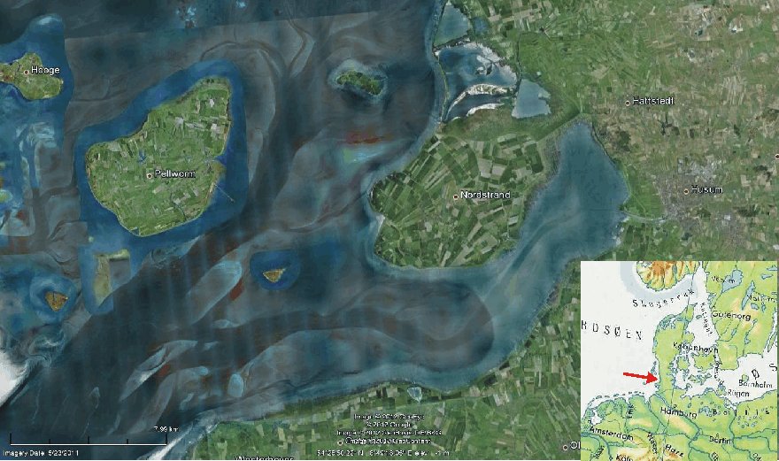
The
islands Pellworm (left) and Nordstrand (right) in northern Germany. The dark
channels between the two land areas are large tidewater channels. Today
Nordstrand is connected to the mainland, and therefore formally again a
peninsula. The picture covers about 45 km from west (left) to east. See insert
map showing Denmark and northern Germany for regional location. Picture source: Google
Earth.
The
summer of 1634 is known to have been warm and dry, with excellent growing
conditions on the fields of Nordstrand, which at that time was a coherent land
area consisting of present Nordstrand and Pellworm, plus the now water covered
areas in between (Pedersen, 1977; and map
below). At that time about 8800 people were living on Nordstrand, distributed on
no less than 1745 houses and farms. Nordstrand was doing quite well, and each
year quantities of farm products were exported to nearby parts of Europe (Pedersen
1977).
Floods
is known to have affected Nordstrand several times before 1634, among others the
‘Grote
Manndränke’ in 1362, and also just few years before 1634 there had been a
strong storm resulting in many areas in Nordstrand being flooded. For that
reason the Danish government had hired the Dutch expert Jan
Adriaansz Leeghwater to supervise a land reclamation project, including
the construction of higher and stronger dikes around Nordstrand.
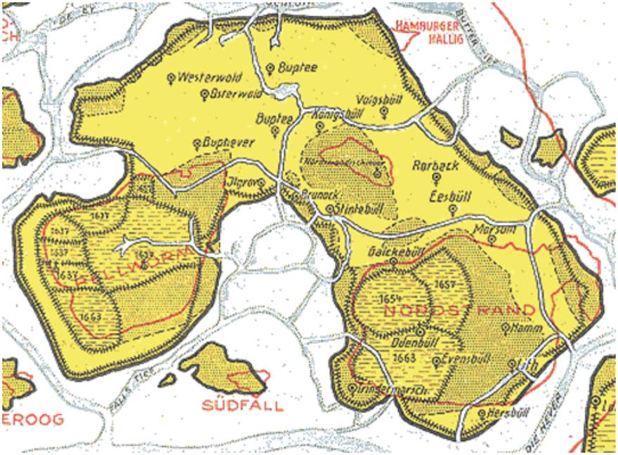
The
geography of Nordstrand before the 1634 flood. The red lines indicate what is
left today of the previous much larger Nordstrand Island: the present-day island
Pellworm (W)
and the small island Nordstrandischmoor (N) and Nordstrand
(SE). Before the 1634 flood the island measured about 25 km from east to west.
Later reclaimed areas (polders) are shown by the year of reclamation. Map
source: Rabbel.nl 2012.
The
first weeks of October 1634 were dominated by stable weather and easterly and
southeasterly winds, but on October 11 the wind turned towards southwest,
increasing in strength, and it soon began to rain. In the evening of October 11
a strong storm was blowing with rain, hail and thunder (Pedersen,
1977). Slowly the still increasing wind began turning from southwest towards
northwest, which is dangerous in this part of the North Sea, as it forces water
into the confined German Bight, leading to rapid increase in sea level along the
adjoining coasts.
Around
22 hr in the evening the dike near Strintebøl at the head of the embayment into
the southern part of the island was overrun by the rising water. This was not
entirely unexpected as this was where the dikes were in a relatively bad
condition, but within one hour also other and higher dikes were broken at no
less than 44 different places around the coasts of the island. There were a
number of inner dikes, but these were also rapidly overrun by the ocean.
Around
midnight between 11 and 12 October 1634, almost the entire island was covered by
several meters of sea water in rapid movement. People had to evacuate to the
uppermost levels in the houses, but often the flowing water and waves eroded the
houses, leading to sudden collapse and drowning of the inhabitants. Any rescue
attempts from the mainland to the east were quite impossible, and most
inhabitants on Nordstrand perished during this night.
Next
morning the entire Nordstrand island had essentially changed into a desert of
sandy sediments. Few areas escaped this flood-driven sedimentation, but they
were still covered by sea water for
a long time. When these areas eventually dried out, the fields were unsuitable
for farming because of the high salt content (Pedersen
1977).
Later
investigations found that 6035 persons of the about 8800 inhabitants had lost
their lives during the flood. Of the 1754 houses and farms 1335 were totally
destroyed. About 50,000 animals were lost. Before the flood there was 22
churches on the island, but due to their solid construction none of these was
entirely destroyed, and many of the survivors actually made it through this
night because they had taken refuge in the churches. However, only three of the
22 churches came into use after the flood. Most of the survivors left Nordstrand
and moved east to the mainland, or to the Netherlands.
The
northern and central parts of what used to be Nordstrand were given up, and
dikes never rebuild. The western part, today called Pellworm,
and the eastern part, todays Nordstrand,
was slowly reclaimed from the sea by construction of new dikes. Slowly big
tidewater channels developed across the former land areas in the central part of
the former Nordstrand, as can be seen from the Google Earth picture above.
The
Dutch dike expert Quirinus Indervelde was
hired to lead the construction of new dikes. As reward Indervelde
and his hundreds of Dutch dike workers were allowed to own the reclaimed land (Rabbel.nl
2012).
The
reclaiming was, however, a very slow process, and it was first in 1654 that the
dikes around the first polder (reclaimed land) were finished. This became the
polder Alterkoog in present day Nordstrand (see map above). In 1657 and 1663,
the polders Osterkoog and Trindermarschkoog were also reclaimed.
By
the reclaiming process extensive parts of Nordstrand and Pellworm became owned
by Deutch people, and they were allowed to practice the Roman Catholic religion,
although the entire Danish kingdom mainly was Lutheran. The Catholic Church on
Nordstrand was under the jurisdiction of the archbishopric of Ytrecht in the
Netherlands. Even today, the archbishopric of Utricht owns about 100 acres of
land on the now German island (Rabbel.nl 2012).
Click here to jump back to the list of contents.
1658: Swedish iceborne invasion of Denmark; the Treaty of Roskilde
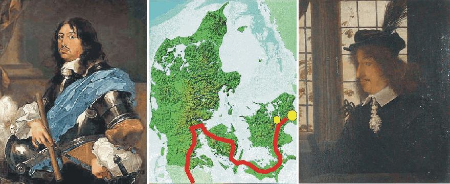
TKing Charles X of Sweden (left). Map of Denmark showing the route taken by the Swedish army. The big yellow circle shows Copenhagen, and the smaller Roskilde (centre). King Frederik III of Denmark (right).
The
Northern Wars (1655-1661) is a collective name used for a series of
conflicts between
Since
1648 Frederik III had been king in
King
Frederik III more or less saw
At the same time King Charles X was ended up in a highly unsatisfactory situation in his war against Poland. The capital Warshaw had been taken according to plan, but despite this it was impossible to reach a decisive conclusion to the hostilities. As Frederik III more or less openly was preparing for attacking the Swedish interests in northern Germany, Charles X saw this as a way out of the messy situation in Poland. Now he would be able to pull out of Poland without making it look like a defeat. Forced marches rapidly took 6,000 Swedish soldiers to Jutland. The Swedish army was not large, but was well equipped and trained, perhaps best in Europe at that time. In addition, it enjoyed the reputation of being invincible.
Danish
resistance was swept away, and all of
The sea between the Danish islands rapidly became ice covered. The Danish government and King Frederik III was quite happy about this development, as the ice would make a shipborn assault impossible. Anyhow, the Danish navy at that time was quite formidable in itself, so any attempt of a seaborne invation was not taken to seriously. But now, with the sea frozen over, any Swedish offensive would surely have to wait until spring, if not later.
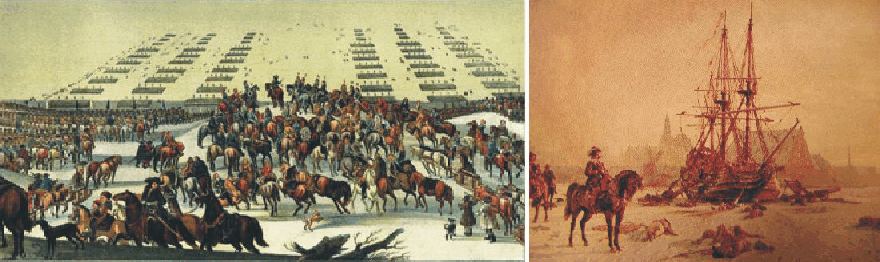
The Swedish army crosses Storebælt between Fyn and Langeland on February 5, 1658 (left). The Danish frigate Højendal surrounded by Swedish ice-borne cavalry at Kalveboderne, Copenhagen, February 18, 1658, (right).
King
Charles X was, however, not a man to be stopped by just a cold winter and some
sea ice. His engineer Erik
Dahlberg was dispatched to ascertain whether the ice would support the weight of
the Swedish cavalry and artillery. In late January 1658 Dahlberg reported that a
crossing over the ice was feasible.
This
part of the operation turned out to be slightly more difficult. While the sound
Lillebælt only is a few kilometres wide, the sound Storebælt between Fyn and
Sjælland is about 40 kilometres wide. However, it was ice covered. Again Erik
Dahlberg led the investigation, and he advised taking the longer route via the
islands Langeland and Lolland to the south, rather than the more direct route
across Storebælt (see map above). The night of February 5 King
Charles X set off with his
cavalry across the ice, and safely reached
This feat was an achievement that drew admiration all over
The people living in Trøndelag and Bormholm were not extremely happy with the treaty of Roskilde, and soon rebelled against Sweden. Neither was King Charles X himself entirely content with his victory, and in complete defiance of international treaty, in July 1659 he again ordered his troops to attack Denmark-Norway. This was, however, not a prudent decision. The Danish capital Copenhagen was able to defend itself successfully against the Swedish Army until help arrived from the Dutch, who acted to honor their 1649 treaty to defend Denmark against any unprovoked invasion. The Dutch fleet then defeated the Swedish fleet in the Battle of the Sound and Copenhagen was relieved. King Charles X suddenly realised the unpleasant fact that his army now was isolated on the Danish islands, likely to be overwhelmed by superior Danish and Dutch forces. King Charles X was in 1659 forced to withdraw from his throne.
Meanwhile
Norwegian forces succeeded in expelling the Swedish occupiers from Trøndelag.
The resulting Treaty of Copenhagen in 1660 restored Trøndelag to
Click here to jump back to the list of contents.
1670-1750:
Increase of geohazards in western Norway 
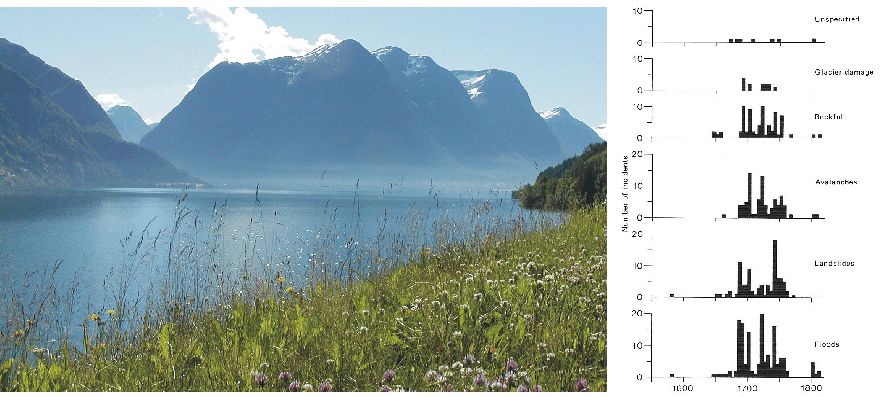
Strynsvatn near Stryn, western Norway, July 2004 (left). Diagram showing frequency of different geohazards in the parishes of Oppstryn, Nedstryn, Loen and Olden (right). Types of geohazards mentioned from top to bottom: unspecified, glacier damage, rockfall, avalanches, landslides and floods. The time axis covers 1580-1820. The frequency of all types of geohazards is seen to reach a maximum 1690-1760.
Grove (1972), Grove and Battagel (1983) and Grove (1988) investigated the incidence of landslides, avalanches and floods in western Norway during the Little Ice Age, using documentary sources. The Norwegian fiscal system at that time had built into it a provision to respond to the incidence of major physical hazards. A petition could be made for tax and land rent relief if a farm was seriously damaged by landslides, rockfalls, avalanches, floods or ice. Crop failure was not included in the list of factors on which an appeal might be based, and only serious physical damage was considered to provide adequate grounds for tax reduction.
The time delay between damage and appeals for tax relief was usually short and less than five years in most cases, making a dating of such events possible (Grove 1988). The frequency of geohazards affecting farms in the valleys peripheral to the northern margins of Jostedalen is shown in the diagram above. It is seen that the incidence of large-scale mass movements of all sorts as well as flooding increased sharply after 1670 and reached maximum frequency in particular decades, such as the 1690s and 1740s. It is evident from the documents investigated that the scale of damage within these periods was unprecedented (Grove 1988). A period of frequent small-scale mass movements in southwest Norway was independently identified as occurring between 1670 and 1720 by Innes (1985), using lichenometry.
The diagram below shows variations of seasonal surface air temperatures in Central England, according to the composite monthly meteorological series originally homogenized by the late professor Gordon Manley (1974). Modern meteorological records show that the Central England record may be used as a proxy for temperatures in western Norway. Periods with extraordinary high frequency of floods and mass movements shown in the diagram above are seen to be associated with periods of low air temperature in the diagram below. This contrasts with the popular modern notion that the frequency of such geohazards is likely to increase in periods with high air temperature. History documents that the relation between temperature change and the frequency of geohazards is opposite to this modern notion: all the above mentioned types of geohazards reach maximum frequency in periods of low air temperature and decreases in periods of high temperature.
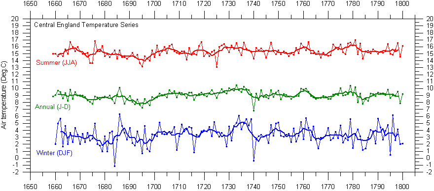
These seasonal temperature graphs has been prepared using the composite monthly meteorological series originally painstakingly homogenized and published by the late professor Gordon Manley (1974). The data series is now updated by the Hadley Centre and may be downloaded from there by clicking here.
Click here to jump back to the list of contents.
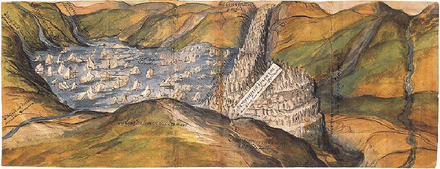
1678:
Vernagtferner in Austria again advances into Rofental and forms an ice dammed lake
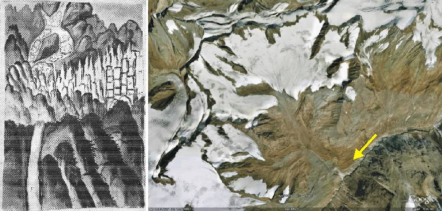
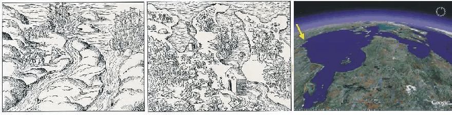
One of the first known drawings of the advancing glacier Vernagtferner in Tirol, Austria. (left). The Vernagtferner is seen advancing into the valley Rofental from the right (northwest), damming up a lake with icebergs upstream of the glacier tongue. Vernagtferner glacier in 2007 (Google Earth), with arrow indicating the direction of view in the drawing to the left (right). The coloured original of the drawing is kept in the Tiroler Landesmuseum in Innsbruck (Hoinkes 1969). The satellite picture measures about 15 km from west to east.
One of the most disastrous floodings of the main valley Ötztal happened on 16 July 1678. This event is reported by an unknown Capuchin father from Imst in the Tirol. His written report contains the drawing above, showing the Vernagtferner damming up the valley shortly before the catastropich drainage (Hoinkes 1969). On the original it can be seen that the Capuchin father apparently had good knowledge on the likely subglacial drainage route, which is indicated by a stippled line and a cross.
A previous example of Little Ice Age advance of the glacier Vernagtferner and formation and drainage of the ice dammed lake is described here. Later advances are described here and here. Click here to read about the initial glacier retreat following the Little Ice Age advances.
Click here to jump back to the list of contents.
1682-1684:
Inuit landings on Orkney Islands, northern Scotland
In the year 1682 an Inuit (Eskimo) in kayak was met at sea and captured near Eday, Orkney Islands (Mikkelsen 1954). An other Iniut visitor in kayak was reported in 1684 from Westray, NW Orkney Islands, as described by the Kirkwall priest James Wallace in a book published 1693 (Mikkelsen 1954). One of these kayaks with hunting equipment was later transported to the University of Edinburgh for scientific investigations. Also the unfortunate Inuit's watertight shirt was send for scrutiny. A new edition of James Wallace's book was published in 1700, and according to this one of the kayaks was placed hanging from the roof in Burray Church, Orkney Islands.
Click here to jump back to the list of contents.
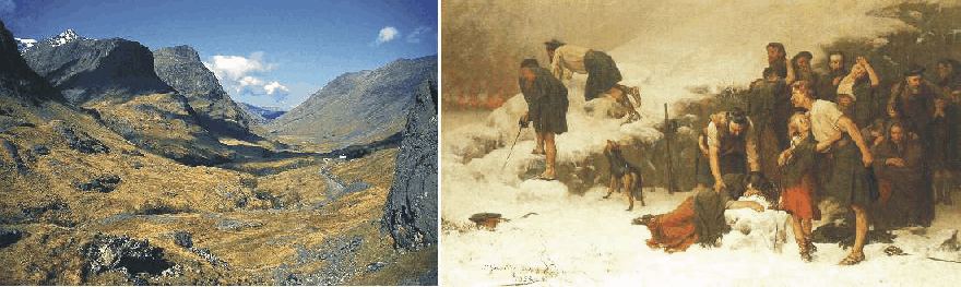
Glencoe in western Scotland, a valley overdeepened by glaciers during the Quaternary ice ages (left). Massacre of Glencoe February 13, 1692, painted by James Hamilton. As the painting suggests the massacre was incompetentently carried out with many of the potential victims escaping from their homes, hidden by a sudden snowstorm (right).
The turbulent history of Glencoe in western Scotland reaches back to Devonian times, about 420 million years ago, when Glencoe was a super volcano. Today, Glencoe is famous worldwide for three reasons. 1) Glencoe is a prominent example of a cauldron subsidence; a volcano that has collapsed in itself. It was one of the first such features to be described, so its historical importance is of considerable geological significance (McKirdy et al. 2007). The size of the block that collapsed about 1,400 m downwards is immense: around 8 kilometres in length. The seismic shock waves generated when these events took place must have reverberated around the world, not to speak about the global climatic importance of the eruption. 2) Glencoe is a classic example of a glacially eroded U-shaped valley, arguably the finest example to be found in Scotland. 3) Glencoe is the place for the infamous Glencoe massacre in 1692.
The late 15th century was difficult times for Scotland. In the year 1688, the Catholic king James VII was ousted from the throne at the request of the English Parliament, by William of Orange, who was supporting Protestantism cause against the Catholic. James accepted his exile, but others in Scotland did not. One was Graham of Claverhouse Viscount Dundee, who decided to raise an army of liberation (Hanley 1995). Hard fighting followed, and for many years Scotland did not settle down to peaceful times. Especially among the highlanders, who were largely cut off from Lowland society in Scotland, loyalty towards the deposed King James still was high.
Some sort of religious peace was, however, established, and along with that came the need for political peace as well. The English King William was not very interested in Scotland, which was considered a cold and damp place in the high north, inhabited by people with a strong and independent mind. His principal minister for Scotland, John Dalrymple, took charge of the royal ordinance that every chief of the Highland clans must abandon their old loyalty towards the Catolic King James and instead swear loyalty to King William.
In general, the Scottish clan chiefs did what was asked. One minor chieftain MacIan of the Clan MacDonald unfortunately got it all wrong. He took his oath to Fort Williams 20 km's travel north of Glencoe in good time, but there he was told that the proper place was Inveraray 80 km's travel south of Fort Williams. In the deep winter in what might been the coldest spell of the Little Ice Age, he got to Inveraray days late, but before the Sheriff who was to accept his declaration had arrived. When the Sheriff finally arrived he of cause accepted the oath without any problem. John Dalrymple, however, who had some personal hatred of the MacDonalds, took the legalistic view that the late oath was invalid, and ordered the MacDonalds extirpated. A Campbell Chieftain, Campbell of Glenlyon (a valley in central Scotland), was ordered to take care of this. Every MacDonald under the age of seventy was to be executed.
The MacDonalds were living in the impressive glacial valley Glencoe (see picture above). The Campbell of Glenlyon with his troops with were arriving in early February 1692, and were received hospitably by the MacDonalds. The following social arrangements with associated drinking took almost two weeks. Then, in the early morning of 13 February 1692 the guests arose and set about murdering their hosts, including women and children.
Because of a sudden snowstorm, many of the MacDonalds managed to escape from the murdering (picture above), while the chieftain himself and his family perished. Especially the treachery of this event has for ever since made Glencoe a fearful word in Scotland, and given every Campbell a burden of accusation to bear. Even today people in Scotland are writing songs about the Massacre of Glencoe, the injustice, the treachery, and the Little Ice Age blizzard which spared the lives of many members of the MacDonald clan.
Click here to jump back to the list of contents.
1693-1700:
Starvation in Scotland
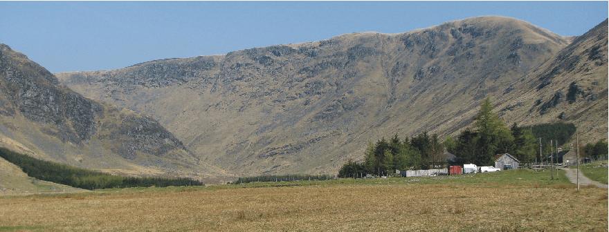
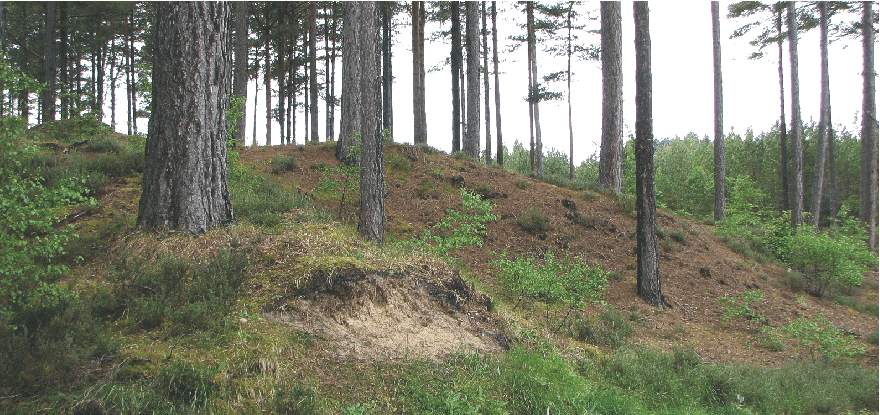
Valley of Glen Clova, Angus, eastern Scotland, 30 September 2007. The mountains rise to about 800-900 m asl., while the valley bottom is at about 250 m asl. Even today this represents the upper limit for intensive farming in this region of Scotland.
In Scotland the 17th century brought the hardest phases of the Little Ice Age (Lamb 1977). In 1612 the government of King James VI of Scotland established in Ulster a 'Plantation' of his Scottish subjects to relieve the suffering arising from continual famines in Scotland, and to reduce their frequency. And so began the long troubled history of Northern Ireland as a consequence of the Little Ice Age cooling effects in Scotland.
It was, however, in the last decade of the 17th century that the worst famine of all during the Little Ice Age would hit Scotland. This is the so-called 'ill years of King William's reign', when there were 7 years of harvest failure out of 8 between 1693 and 1700. All harvest failures occurred in the upland parishes of Scotland, and caused more people to die of starvation at that time than caused by the Black Death of 1348-1350. Also a bigger proportion of the total population died than during the Black Death. There are also numerous reports from travellers of the time of permanent snow on the tops of the Cairngorms and elsewhere in the Scottish mountains (Lamb 1995).
All trough
the Little Ice Age, from 1550 onwards, Scotland developed and maintained trade
with the Baltic as her 'emergency granary' for years of need. In particular this
trade took place with Danzig, an outlet for exports from the Polish grainlands.
Later Kö
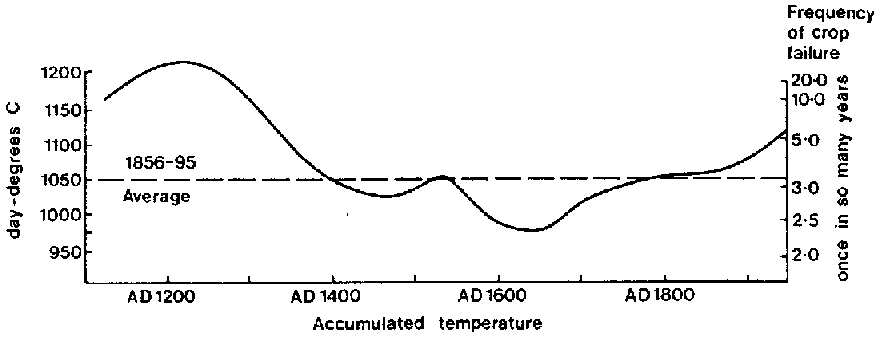
Diagram showing the estimated average number of degree-days during the growing season year 1130-1950 for sites in SE Scotland, near the upper limit of cereal cultivation (diagram by M.L. Parry, in Lamb 1995). The probable frequency of failures of the oat harvest at such sites can be read off the scale at the right of the diagram.
Click here to jump back to the list of contents.
1694:
The Culbin Sands disaster in northeast Scotland
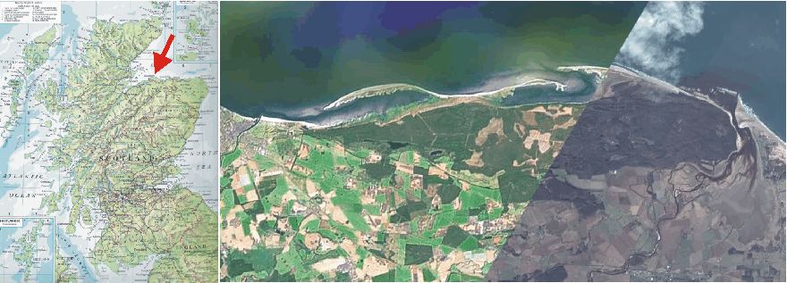
Scotland with location of Culbin Sands indicated by red arrow (left). Satellite picture and air photo showing Culbin Sands, today covered by forest (dark green, right). The rivers Nairn and Findhorn are seen to the left and right, respectively. The geometry of the coastal barriers (white due to lack of vegetation) shows the net coastal transport to be from NE towards SW (left). This suggests the river Findhorn to be the main sediment source for the sand now accumulated in the Culbin Sands. The picture covers a distance of 20 km from east to west. North is upward to the right, parallel to the border between the two types of pictures. Picture source: Google Earth.
Little
more than 300 years ago there was a very fertile and well-cultivated estate on the
southern shore of the
In many respects, this part of Scotland enjoys a mild and pleasant climate, sheltered as it is by mountains both to the west and to the south. The number of warm summer days with sun from a clear sky is relatively high due to this topographic setting, and during winter the nearby North Sea ensures that air temperatures seldom drops more than a few degrees below freezing. The mountains also protect against winter storms with westerly wind direction The area, however, has one climatic weakness: It has little protection against strong winds from N and NW, wind directions often accompanying travelling weather systems (cyclones) on their backside. In combination with huge amounts of sand eroded from glacial deposits inland and being deposited on the coast west and east of the area by the rivers Nairn and Findhorn, this lack of protection against northwesterly winds was to be the background for the major storm disaster in 1694.
Culbin Sands near Kintessack, looking NW on June 2, 2008. The forest in the background delimits the southernmost part of of the sand dune field which extends 2-3 km inland from the coast. The houses in the middle ground are located on the small remnants of the fertile farming areas which barely escaped destruction during the 1694 storm.
The precise data of the 1694 storm is not known, but presumably it was late October or early November, as reports from the frigate S/S Packan at that time indicate a very severe storm with force 11 suggested. In addition, London reported an unbroken 10-day period of N and NW winds with frequent frost, snow and sleet leading up to the end of October 1694. Stavanger in Norway on 31 October reported snow and hail showers, while Copenhagen in Denmark had frost (Lamb 1991).
By the 1694 storm 16 fertile farms and farmland with a total area of 20-30 km2 were overwhelmed by moving sand within the Culbin area. The whole area and the buildings were buried with depths of up to 30 m loose sand. Presumably this was not the first storm with problems derived from moving sand, and there has been discussions on the extent of the sand dunes before the disaster. There apparently was another severe episode of blowing sand in the Culbin area on 21 April 1663, and in the autumn of 1676 a NW storm buried the harvest on the westernmost Culbin farms with up to 50-60 cm of sand (Lamb 1991).
Before the 1694 disaster, Culbin was shown on a 17th century map as being on a peninsula between two bays (Edlin 1976). It was at that time a prosperous area, known as 'the Garden', or alternatively 'the Granary', of the county of Moray.
Reports of the disaster tell that it came during the barley harvest, which in the cool summers of the 1690s was probably late, most likely in late October. In upland parts of Scotland, the largely failed harvests of that decade (including 1694) were generally cut later than late October, but presumably in the fertile lowlands along the south shore of Moray Firth the overall situation was more favourable.
Edlin (1976) and Lamb (1991) cites the following accounts from the event: 'At first only fields were invaded by the sand. A ploughman had to leave his plough, while reapers left their stocks of barley. When the returned, both plough and barley were buried for ever. The drift the advanced upon the village, engulfing cottages and the laird's mansion. The storm continued through the night, and the next morning some of the cottars had to break through the backs of their houses to get out. On the second day of the storm, the people freed their cattle and fled with their belongings to safer ground. Their flight (downwind, SE) was obstructed by the river Findhorn: since its mouth had been blocked by the drifting sand, its waters rose until it could force a new passage to the sea'. When this eventually happened, the water masses swept away the ancient town and harbour of Findhorn on the east bank of the river, shifting the river's month nearly 2 miles eastward to its present position (Chambers 1861). When the population of Culbin returned after the storm, no traces of their houses were to be seen.
Sand dunes near Wellhill, Culbin Sands, looking upwind (NW) on June 2, 2008. The sand dunes in the area are typically 5-25 m high, and extends 12 km parallel to the coast, and to a maximum distance of 3 km inland. The old fertile farmland and farms are still buried beneath the 28 km2 sand cover.
Many stories, the product of naturally curious and superstitious minds, developed in the time following the disaster. How could such a disaster befall the once wealthy lands and families of Culbin ? Women were accused of witchcraft and put to death by the Laird who, in turn, was accused of playing cards on a Sunday with the Devil with his estates at stake.
For over a hundred years the Culbin Sands remained a sand desert. The land was sold several times and divided into smaller estates. It was, however, not until 1839 that anything was successfully grown on it. Then, Grant of Kincorth, growing marram grass to stabilise the sand planted the first shelter belt to be successful. In 1842 Grigor of Forres, a tree nurseryman, planted 300 acres on Moy Estate. He introduced the technique of 'thatching' to tree planting in Culbin, which turned out to be the key to the ultimate success of planting trees on sand dunes. Branches and tops of trees cut for thinning were laid on the ground, the tree seedlings being planted through the branches. These dead branches remained, holding the sand, protecting the small trees from wind slowing down the evaporation of moisture from the soil. Between 1922 and 1945 the estates constituting Culbin were acquired by the forestry Commission who, over a period of 32 years, planted over 9000 acres of trees. They stabilised the mobile sand by first planting marram grass whose plexus of spreading roots bound the sand. This was successful on the less hilly terrain but the thatching system, pioneered by Grigor in 1841, was found to be necessary for holding the larger sand dunes. Most of Culbin sands is now afforested.
During the 2nd World War the extensive tidal flats north of Culbin Sands were considered a possible landing area for airplanes and gliders, should Germany attempt an invasion of the British Isles. To prevent this, a large number of wooden poles were dug into the tidal flats. Many of these poles can still be seen. Later in the war, a large part of Culbin and adjacent coastal areas were commandeered by the British Army for manoeuvres in preparation for the D-Day landings. 'Lost' shells and rockets have been found during planting and in 1986 a wrecked aircraft was discovered, having lain undisturbed for 40 years within the dune field.
1966 the Nature Conservancy Council (forerunner of Scottish Natural Heritage) designated the Culbin area a Site of Special Scientific Interest. It also now forms part of a Ramsar site, a Special Protection Area. This unique region is now frequently visited and studied by geologists, botanists and zoologists and other interested parties from around the world.
Proximal (upwind) side of 10-15 m high sand dune in central Culbin Sands, looking E on June 2, 2008. The threes growing on top of the dune provides the scale.
Lamb (1991) carried out an analysis of the likely meteorological situation leading to the storm destroying the Culbin area, citing, among others, Willis (1986). It is concluded that the fatal 1694 storm winds indeed were blowing from the NW, exposing pre-existing coastal sand dunes to the full force of the wind. At low tide, also the extensive sandy tidal flats (see satellite picture above) beyond the coast would have been exposed to wind erosion, generating additional amounts of wind-blown sand. Finally, excessive plucking of the marram grass on the coastal dunes may have contributed to exposing their surface for wind erosion. That this may have been a contributing factor is indicated by an Act of the Scottish parliament in 1695 (the year after the disaster) forbidding the pulling of marram grass for thatching. However, Lamb (1991) concludes that the winds associated with the 1694 NW storm must have been exceptionally strong, and presumably lasted for about 30 hours without interruption. Gust wind speeds during the storm are estimated to have reached 50-65 m/s, while the mean wind speed may have been around 25-30 m/s.
Edlin (1976) concluded that the new landscape produced by the 1694 storm, today known as the Culbin Sands, probably represents one of the greatest wind-borne deposits formed anywhere in Britain in recent geological time.
Lamb (1991) further draws attention to the fact that this was the time during the Little Ice Age, where the polar pack ice expanded farthest south into the North Atlantic, surrounding Iceland completely by the end of the year. Although the polar waters had long extended further south than what has been normal during the 20th century, the reported swift advance of the polar ice-pack limit between October and December 1694 must have required continual northerly strong winds over much of the North Atlantic north of Iceland. The Culbin Sands may thus be perceived as the geomorphological result of a climatic situation with the oceanic Polar Front taking a very southerly position, in the vicinity of northern Scotland.
Click here to jump back to the list of contents.
1699:
Storage of snow on Gran Canaria
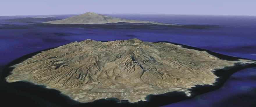
The volcanic island Gran Canaria west of NW Africa, looking WNW. The highest mountain Pico de las Nieves reaches 1949 m asl. In the background the island Tenerife is seen. Source: Google Earth.
In the year 1699 the city council in Las Palmas on Gran Canaria (28oN, 16oW) decides that a facility for collection of winter snow should be constructed near the summit of the highest mountain Pico de las Nieves (1949 m asl.). Parallel to the situation on Mallorca in the Mediterranean this facility (Pozo de las Nieves; 1910 m asl.) was to be used for storage of winter snow until summer, when the snow was transported to lower altitudes for cooling purposes.
I am grateful to Professor J-E. Solheim (University of Oslo, Norway), for supplying me with the above information.
Click here to jump back to the list of contents.