-
Essay on past and present climate effects on society and science (in Nordic language only)
-
Increase of mid-latitude storms during the climatic decline following the medieval warm period
Open Climate4you homepage
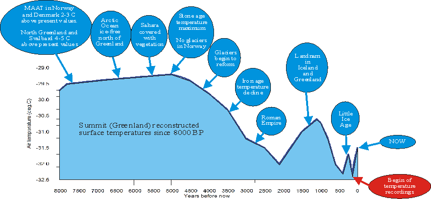
Generalised temperature diagram based on temperature measurements in the Greenland Ice Sheet (Dahl-Jensen et al. 1998), annotated with a number of historical events around the North Atlantic. MAAT is short for mean annual air temperature. Some of the text in the diagram contains links to additional information.
Man's history has been played out in an ever-changing world, the changes sometimes slow, sometimes fast, the nature of the long-term changes always obscured by the much bigger swings that distinguish the individual years. The environment will continue to change, partly due to human activities, and partly due to natural causes.
The notion that climate change represents an important driver for major cultural developments (e.g., agriculture), has not always been welcomed among archaeologists and historians. In the last 20-30 years, however, this has undergone a change. Today climate and climate change is seen by most academicians as an important cultural driver among others. In fact, the written historical record is surprisingly rich in references to situations, where climate or meteorological events can be demonstrated have had direct influence on human affairs. Written documentation describing direct observations are in some ways superior to standard proxies for palaeoclimate, such as e.g. three rings and isotopes, which need calibration to be translated into temperature, precipitation, or combinations of this. Not the least military and naval records, which often describe past meteorological events in great detail, is a valuable source for climatic information.
The impact of climatic change on society is inevitably coincident with that of many other factors, social, economic and political, which also influence the human environment. Climate is most influential in areas marginal for agriculture either latitudinally or altitudinally. Thus, climate and meteorology are not the only decisive historical factor for the wellbeing of human societies, but the historical records leave little doubt that the natural phenomena do carry importance, and continues to do so in modern times. The widespread interest attached to the notion of global warming testifies to that. Today it is easy to forget how little time has passed since Europeans went hungry because of climate-induced harvest failure.
The historical record on past effects of climate change demonstrates that periods of cooling usually generally are periods of human suffering and cultural recession, while periods of warming usually have been characterized by prosperity and cultural advances. Today it is easy to forget how little time has passed since Europeans went hungry because of climate-induced harvest failure. It is interesting to note that this historical knowledge contrasts with many modern interpretations of effects of a modelled future warmer climate. An essay on past and present climatic effects on society and science can be downloaded by clicking here (at the moment only available in Nordic language).
Click here to jump back to the list of contents.
Further down the present page, starting from year 1850, you will see one or two small icons as shown below. Clicking on the left icon opens a window with a diagram showing the relevant HadCRU3 surface air temperature estimate according to Hadley Centre for Climate Prediction and Research and the University of East Anglia's Climatic Research Unit (CRU). The actual temperature diagram shown depends on the theme and event under consideration. Clicking on the icon to the right opens a window showing an air temperature record from the locality in question, or from a nearby location. This facility might be useful to relate different historical events to contemporary air temperature changes. The two icons shown below opens a random example data file.


Below each historical theme you will find an option to jump directly back to the list of contents shown below. Finally, please note that this is a preliminary version of the final web page, and that supplementary themes will be added in the time to come.
Click here to jump back to the list of contents.
During
the first 800-1000 years following the birth of Christ Europe was a poor,
disorganised continent, divided into numerous small entities, typically centred
on a castle and a surrounding village. The so-called European miracle had still
not begun. It was very difficult to obtain a bigger harvest than needed for the
mere survival of the farmer and his family. People in
Around the
year 1000 the total population of
From year
1000 to 1300 the number of people living in
The Norse
(Viking) population in
An increase of mid-latitude storms during the climatic decline following the medieval warm period
Inhabitants of Europe presumably first noticed an increased frequency and severity of mid-latitude storms as climate began to cool in the late 13th century. Especially around the North Sea the increased incidence and severity of storms and sea floods became apparent. In at least four sea floods of the Dutch and German coasts the death toll was estimated at around 100,000 or more; in the worst case the estimate was 306,000 (Lamb 1977). In southwestern Denmark it was reported that sixty parishes accounting for over half of the agricultural income of southern Slesvig (at that time part of Denmark) had been 'swallowed by the salt sea'. In some of these strong storms the Zuiderzee in the Netherland was formed. The dimensions of the island Helgoland in the German Bight was seriously reduced by coastal erosion. In the year 800, Helgoland is reported to measure about 60 km across; yet around year 1300 this was reduced to 25 km only. Exposed to severe coastal erosion by the many storms characterising the following Little Ice Age, Helgoland now only measures 1.5 km across.
Examples of Little Ice Age storms and associated landscape and/or effects can be found by clicking here, here, here, here, here, here, here, here, and here.
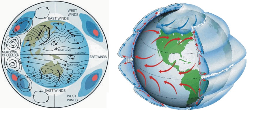
Atmospheric circulation. It is the uequal heating of different zones of the Earth that sets the atmosphere in motion. Near the equator where heating is at maximum, the lower atmosphere expands and lift the atmosphere above. By contrast, near the poles the lower atmosphere shrinks due to cooling and the upper atmosphere descends somewhat. High in the atmosphere this introduces a pressure gradient towards the poles, and air in the upper atmosphere begin to move down this gradient. Because of the rotation of the planet, the resulting movement turns out to be not down the pressure gradient but instead almost along the lines of equal pressure, giving rise to several circulation systems as shown. Where air masses sink toward the planet surface north and south of the equator, high pressure regions will develop at the surface, from where air will flow south and north. These regions are dry and most af the planets deserts are found here. Further in direction of the poles warm subtropical air masses will meet cold and dense air masses of Arctic or Antarctic origin. Because of the rotation of the planet, strong westerly winds (the westerlies) tend to develop at this mid-lattitude collision zone. It is also here where the mid-latitude storms develop and travel east along the collision zone (see figure below). When the thermal contrast across the mid-latitude zone is high, many strong storms develop, and less so in periods where the thermal contrast is smaller. The thermal contrast is high when the planet is relatively cold, and smaller when the planet is relatively warm
From a meteorological point of view, this troublesome development in the late medieval time was the result of global cooling. When the planet cools, the cooling is especially pronounced near the poles and smaller near the equator. Along with planetary cooling, this therefore produces an enhanched thermal contrast between equatorial regions and the poles. In the northern hemisphere, this thermal contrast tend to develop especially in latitudes between about 50 and 65oN, in the zone of westerlies. This strengthened thermal gradient is the basis for development of more cyclonic storms over oceans in this zone, leading to increasing flood frequency and damage for adjoining coasts and land areas (see diagrams above).
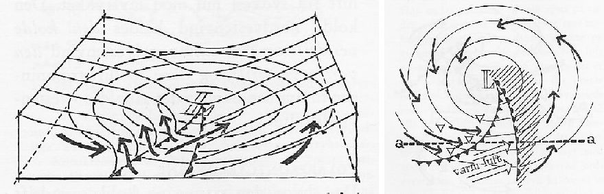
Structure of a mid-latitude cyclone in the northern hemisphere. The form of the upper surface of the cold polar air masses is shown with parallel lines in the diagram to the left. Lighter warm air masses overlie the cold air, except where a wedge of warm air extends to the planet surface south of the centre of the cyclone. The arrows indicate air movement. On either side of the wedge warm air masses is lifted to higher altitudes, whereby clouds and precipitation is generated. The diagram to the right illustrates wind conditions at the planet surface, with a general air flow around the low pressure centre as shown. In the southern hemisphere, because of the rotation of Earth, the flow is opposite. The whole system travels east following the curved collision zone between polar and subtropical air masses.
In the zone of westerlies, there will always be points of imbalance in the flow of the air masses. Some places the air masses are accelerated, while deceleration take place at other places. So the flowing air masses may not always conform well with the pattern of the lines of equal pressure. Where this happens, air masses may be piling up in one region and remove some air from another region, thereby itself generating local changes in air pressure at the planet surface. This is the way the high and low pressure systems, anticylones and cyclones (or depressions), respectively, are formed at the planet surface. At places where depressions are forming, warm moist air masses of subtropical origin will be lifted as shown in the figure above, and give rise to clouds and precipitation. At places where high pressure systems form, dry air masses will come to the planet surface from higher levels in the atmosphere. The typical weather will be clear and dry; warm in the summer and cold in the winter. Both high and low pressure systems travel east along the curved interface between polar and subtropical air masses.